Babylon, the capital of the Fourth Monarchy, was probably the largest and most magnificent city of the ancient world. A dim tradition current in the East gave, it is true, a greater extent, if not a greater splendor, to the metropolis of Assyria; but this tradition first appears in ages subsequent to the complete destruction of the more northern city; and it is contradicted by the testimony of facts. The walls of Nineveh have been completely traced, and indicate a city three miles in length, by less than a mile and a half in breadth, containing an area of about 1800 English acres. Of this area less than one tenth is occupied by ruins of any pretension. On the admitted site of Babylon striking masses of ruin cover a space considerably larger than that which at Nineveh constitutes the whole area of the town. Beyond this space in every direction, north, east, south and west, are detached mounds indicating the former existence of edifices of some size, while the intermediate ground between these mounds and the main ruins shows distinct traces of its having been built upon in former days.
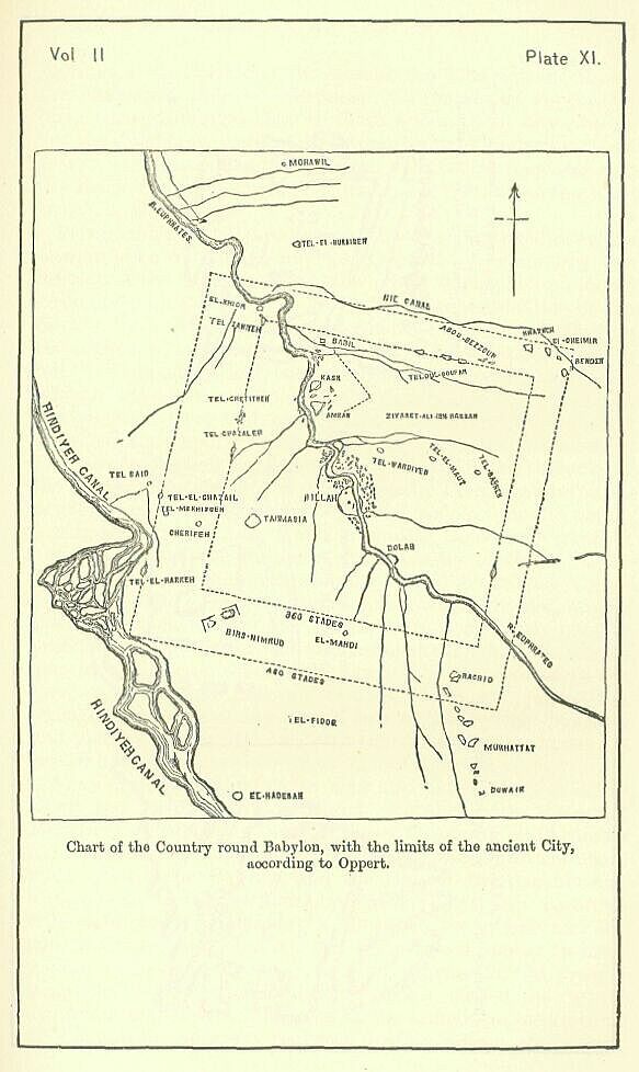
Of the actual size of the town, modern research gives us no clear and definite notion. One explorer only has come away from the country with an idea that the general position of the detached mounds, by which the plain around Hillah is dotted, enables him to draw the lines of the ancient walls, and mark out the exact position of the city. But the very maps and plans which are put forward in support of this view show that it rests mainly on hypothesis; nor is complete confidence placed in the surveys on which the maps and plans have been constructed. The English surveys, which have been unfortunately lost, are said not to have placed the detached mounds in any such decided lines as M. Oppert believes them to occupy, and the general impression of the British officers who were employed on the service is that "no vestige of the walls of Babylon has been as yet discovered." [PLATE XI.]
For the size and plan of the city we are thus of necessity thrown back upon the reports of ancient authors. It is not pretended that such reports are in this, or in any other case, deserving of implicit credence. The ancient historians, even the more trustworthy of them, are in the habit of exaggerating in their numbers; and on such subjects as measurements they were apt to take on trust the declarations of their native guides, who would be sure to make over-statements. Still in this instance we have so many distinct authorities—eyewitnesses of the facts—and some of them belonging to times when scientific accuracy had begun to be appreciated, that we must be very in credulous if we do not accept their witness, so far as it is consentient, and not intrinsically very improbable.
According to Herodotus, an eye-witness, and the earliest authority on the subject the enceinte of Babylon was a square, 120 stades (about 14 miles) each way—the entire circuit of the wall being thus 56 miles, and the area enclosed within them falling little short of 200 square miles. Ctesias, also an eyewitness, and the next writer on the subject, reduced the circuit of the walls to 360 stades, or 41 miles, and made the area consequently little more than 100 square miles. These two estimates are respectively the greatest and the least that have come down to us. The historians of Alexander, while conforming nearly to the statements of Ctesias, a little enlarge his dimensions, making the circuit 365, 368, or 385 stades. The differences here are inconsiderable; and it seems to be established, on a weight of testimony which we rarely possess in such a matter, that the walls of this great town were about forty miles in circumference, and enclosed an area as large as that of the Landgraviat of Hesse-Homburg.
It is difficult to suppose that the real city—the streets and squares—can at any time have occupied one half of this enormous area, A clear space, we are told, was left for a considerable distance inside the wall—like the pomaerium of the Romans—upon which no houses were allowed to be built. When houses began, they were far from being continuous; gardens, orchards, even fields, were interspersed among the buildings; and it was supposed that the inhabitants, when besieged, could grow sufficient corn for their own consumption within the walls. Still the whole area was laid out with straight streets, or perhaps one should say with roads (for the houses cannot have been continuous along them), which cut one another everywhere at right angles, like the streets of some German towns. The wall of the town was pierced with a hundred gates, twenty-five (we may suppose) in each face, and the roads led straight to these portals, the whole area being thus cut up into square blocks. The houses were in general lofty, being three or even four stories high. They are said to have had vaulted roofs, which were not protected externally with any tiling, since the climate was so dry as to render such a protection unnecessary. The beams used in the houses were of palm-wood, all other timber being scarce in the country; and such pillars as the houses could boast were of the same material. The construction of these last was very rude. Around posts of palm-wood were twisted wisps of rushes, which were covered with plaster, and then colored according the taste of the owner.
The Euphrates ran through the town, dividing it nearly in half. Its banks were lined throughout with quays of brick laid in bitumen, and were further guarded by two walls of brick, which skirted them along their whole length. In each of these walls were twenty-five gates, corresponding to the number of the streets which gave upon the river; and outside each gate was a sloped landing place, by which you could descend to the water's edge, if you had occasion to cross the river. Boats were kept ready at these landing-places to convey passengers from side to side; while for those who disliked this method of conveyance a bridge was provided of a somewhat peculiar construction. A number of stone piers were erected in the bed of the stream, firmly clamped together with fastenings of iron and lead; wooden drawbridges connected pier with pier during the day, and on these passengers passed over; but at night they were withdrawn, in order that the bridge might not be used during the dark. Diodorus declares that besides this bridge, to which he assigns a length of five stades (about 1000 yards) and a breadth of 30 feet, the two sides of the river were joined together by a tunnel, which was fifteen feet wide and twelve high to the spring of its arched roof.
The most remarkable buildings which the city contained were the two palaces, one on either side of the river, and the great temple of Belus. Herodotus describes the great temple as contained within a square enclosure, two stades (nearly a quarter of a mile) both in length and breadth. Its chief feature was the ziggurat or tower, a huge solid mass of brick-work, built (like all Babylonian temple-towers) in stages, square being emplaced on square, and a sort of rude pyramid being thus formed, at the top of which was the main shrine of the god. The basement platform of the Belus tower was, Herodotus tells us, a stade, or rather more than 200 yards, each way. The number of stages was eight. The ascent to the highest stage, which contained the shrine of the god, was on the outside, and consisted either of steps, or of an inclined plane, carried round the four sides of the building, and in this way conducting to the top. According to Strabo the tower was a stado (606 feet 9 inches) in height; but this estimate, if it is anything more than a conjecture, must represent rather the length of the winding ascent than the real altitude of the building. The great pyramid itself was only 480 feet high; and it is very questionable whether any Babylonian building ever equalled it. About half-way up the ascent was a resting-place with seats, where persons commonly sat a while on their way to the summit. The shrine which crowned the edifice was large and rich. In the time of Herodotus it contained no image; but only a golden table and a large couch, covered with a handsome drapery. This, however, was after the Persian conquest and the plunder of its principal treasures. Previously, if we may believe Diodorus, the shrine was occupied by three colossal images of gold—one of Bel, one of Beltis, and the third of Rhea or Ishtar. Before the image of Beltis were two golden lions, and near them two enormous serpents of silver, each thirty talents in weight. The golden table—forty feet long and fifteen broad—was in front of these statues, and upon it stood two huge drinking-cups, of the same weight as the serpents. The shrine also contained two enormous censers and three golden bowls, one for each of the three deities.
At the base of the tower was a second shrine or chapel, which in the time of Herodotus contained a sitting image of Bel, made of gold, with a golden table in front of it, and a stand for the image, of the same precious metal. Here, too, Persian avarice had been busy; for anciently this shrine had possessed a second statue, which was a human figure twelve cubits high, made of solid gold. The shrine was also rich in private offerings. Outside the building, but within the sacred enclosure, were two altars, a smaller one of gold, on which it was customary to offer sucklings, and a larger one, probably of stone, where the worshippers sacrificed full-grown victims.
The great palace was a building of still larger dimensions than the great temple. According to Diodorus, it was situated within a triple enclosure, the innermost wall being twenty stades, the second forty stades, and the outermost sixty stades (nearly seven miles), in circumference. The outer wall was built entirely of plain baked brick. The middle and inner walls were of the same material, fronted with enamelled bricks representing hunting scenes. The figures, according to this author, were larger than the life, and consisted chiefly of a great variety of animal forms. There were not wanting, however, a certain number of human forms to enliven the scene; and among these were two—a man thrusting his spear through a lion, and a woman on horseback aiming at a leopard with her javelin—which the later Greeks believed to represent the mythic Ninus and Semiramis. Of the character of the apartments we hear nothing; but we are told that the palace had three gates, two of which were of bronze, and that these had to be opened and shut by a machine.
But the main glory of the palace was its pleasure-ground—the "Hanging Gardens," which the Greeks regarded as one of the seven wonders of the world. This extraordinary construction, which owed its erection to the whim of a woman, was a square, each side of which measured 400 Greek feet. It was supported upon several tiers of open arches, built one over the other, like the walls of a classic theatre, and sustaining at each stage, or story, a solid platform, from which the piers of the next tier of arches rose. The building towered into the air to the height of at least seventy-five feet, and was covered at the top with a great mass of earth, in which there grew not merely flowers and shrubs, but tress also of the largest size. Water was supplied from the Euphrates through pipes, and was raised (it is said) by a screw, working on the principal of Archimedes. To prevent the moisture from penetrating into the brick-work and gradually destroying the building, there were interposed between the bricks and the mass of soil, first a layer of reeds mixed with bitumen, then a double layer of burnt brick cemented with gypsum, and thirdly a coating of sheet lead. The ascent to the garden was by steps. On the way up, among the arches which sustained the building, were stately apartments, which, must have been pleasant from their coolness. There was also a chamber within the structure containing the machinery by which the water was raised.
Of the smaller palace, which was opposite to the larger one, on the other side the river, but few details have come down to us. Like the larger palace, it was guarded by a triple enclosure, the entire circuit of which measured (it is said) thirty stades. It contained a number of bronze statues, which the Greeks believed to represent the god Belus, and the sovereigns Ninus and Semiramis, together with their officers. The walls were covered with battle scenes and hunting scenes, vividly represented by means of bricks painted and enamelled.
Such was the general character of the town and its chief edifices, if we may believe the descriptions of eye-witnesses. The walls which enclosed and guarded the whole—or which, perhaps one should rather say, guarded the district within which Babylon was placed—have been already mentioned as remarkable for their great extent, but cannot be dismissed without a more special and minute description. Like the "Hanging Gardens," they were included among the "world's seven wonders," and, according to every account given of them, their magnitude and construction were remarkable.
It has been already noticed that, according to the lowest of the ancient estimates, the entire length of the walls was 360 stades, or more than forty-one miles. With respect to the width we have two very different statements, one by Herodotus and the other by Clitarchus and Strabo. Herodotus makes the width 50 royal cubits, or about 85 English feet, Strabo and Q. Curtius reduced the estimate to 32 feet. There is still greater discrepancy with respect to the height of the walls. Herodotus says that the height was 200 royal cubits, or 300 royal feet (about 335 English feet); Ctesias made it 50 fathoms, or 300 ordinary Greek feet; Pliny and Solinus, substituting feet for the royal cubits of Herodotus, made the altitude 235 feet; Philostratus and Q. Curtius, following perhaps some one of Alexander's historians, gave for the height 150 feet; finally Clitarchus, as reported by Diodorus Siculus, and Strabo, who probably followed him, have left us the very moderate estimate of 75 feet. It is impossible to reconcile these numbers. The supposition that some of them belong properly to the outer, and others to the inner wall, will not explain the discrepancies—for the measurements cannot by any ingenuity be reduced to two sets of dimensions. The only conclusion which it seems possible to draw from the conflicting testimony is that the numbers were either rough guesses made by very unskilful travellers, or else were (in most cases) intentional exaggerations palmed upon them by the native ciceroni. Still the broad facts remain—first, that the walls enclosed an enormous space, which was very partially occupied by buildings; secondly, that they were of great and unusual thickness; and thirdly, that they were of a vast height—seventy or eighty feet at least in the time of Alexander, after the wear and tear of centuries and the violence of at least three conquerors.
The general character of the construction is open to but little doubt. The wall was made of bricks, either baked in kilns, or (more probably) dried in the sun, and laid in a cement of bitumen, with occasional layers of reeds between the courses. Externally it was protected by a wide and deep moat. On the summit were low towers, rising above the wall to the height of some ten or fifteen feet, and probably serving as guardrooms for the defenders. These towers are said to have been 250 in number; they were least numerous on the western face of the city, where the wall ran along the marshes. They were probably angular, not round; and instead of extending through the whole thickness of the wall, they were placed along its outer and inner edge, tower facing tower, with a wide space between them—"enough," Herodotus says, "for a four-horse chariot to turn in." The wall did not depend on them for its strength, but on its own height and thickness, which were such as to render scaling and mining equally hopeless.
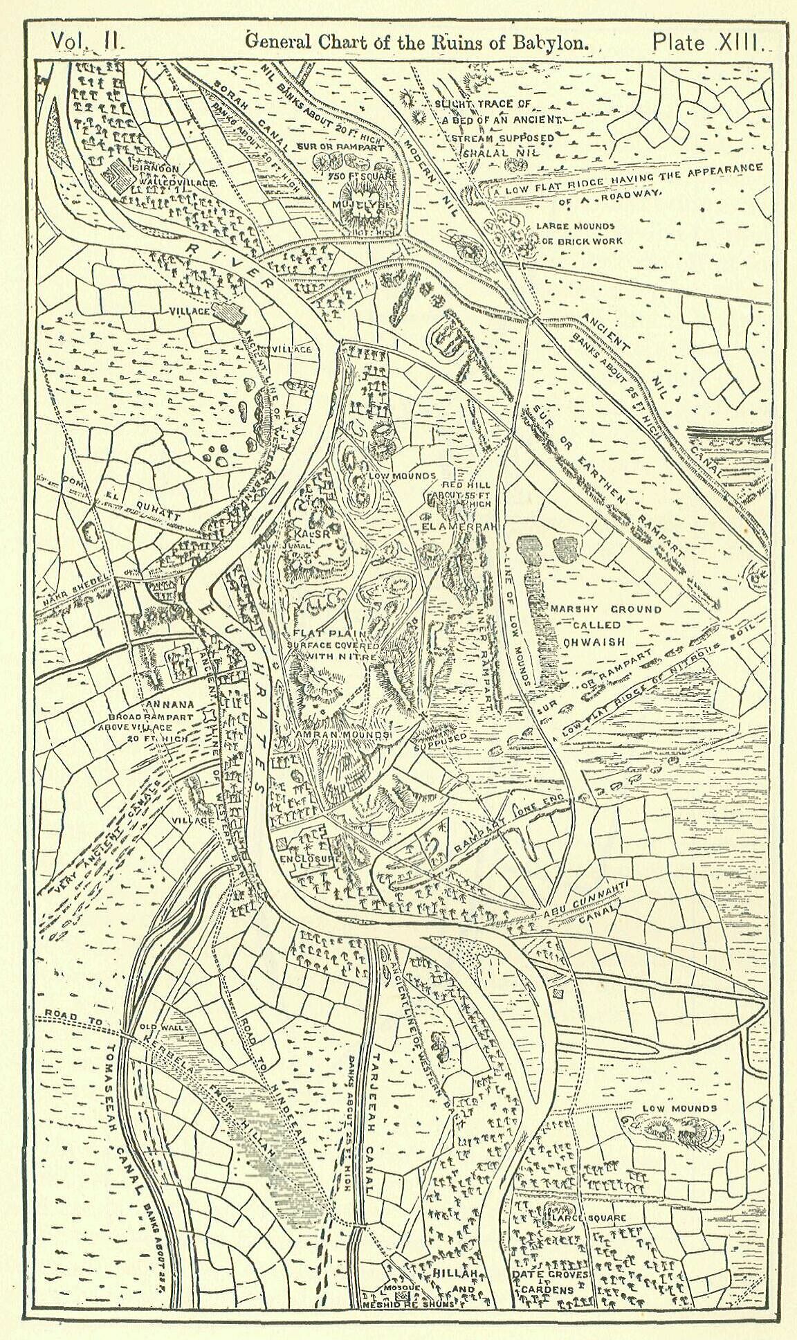
Such was Babylon, according to the descriptions of the ancients—a great city, built on a very regular plan, surrounded by populous suburbs interspersed among fields and gardens, the whole being included within a large square strongly fortified enceinte. When we turn from this picture of the past to contemplate the present condition of the localities, we are at first struck with astonishment at the small traces which remain of so vast and wonderful a metropolis. "The broad walls of Babylon" are "utterly broken" down, and her "high gates burned with fire." "The golden city hath ceased." God has "swept it with the bosom of destruction." "The glory of the kingdoms, the beauty of the Chaldees' excellency," is become "as when God overthrew Sodom and Gomorrha." The traveller who passes through the land is at first inclined to say that there are no ruins, no remains, of the mighty city which once lorded it over the earth. By and by, however, he begins to see that though ruins, in the common acceptation of the term, scarcely exist—though there are no arches, no pillars, but one or two appearances of masonry even yet the whole country is covered with traces of exactly that kind which it was prophesied Babylon should leave. Vast "heaps" or mounds, shapeless and unsightly, are scattered at intervals over the entire region where it is certain that Babylon anciently stood, and between the "heaps" the soil is in many places composed of fragments of pottery and bricks, and deeply impregnated with nitre, infallible indications of its having once been covered with buildings. As the traveller descends southward from Baghdad he finds these indications increase, until, on nearing the Euphrates, a few miles beyond Mohawil, he notes that they have become continuous, and finds himself in a region of mounds, some of which are of enormous size.
These mounds begin about five miles above Hillah, and extend for a distance of about three miles from north to south along the course of the river, lying principally on its left or eastern bank. The ruins on this side consist chiefly of three great masses of building. The most northern, to which the Arabs of the present day apply the name of BABIL—the true native appellation of the ancient citys—is a vast pile of brick-work of an irregular quadrilateral shape, with precipitous sides furrowed by ravines, and with a flat top. [PLATE X., Fig.,3.] Of the four faces of the ruin the southern seems to be the most perfect. It extends a distance of about 200 yards, or almost exactly a stade, and runs nearly in a straight line from west to east. At its eastern extremity it forms a right angle with the east face, which runs nearly due north for about 180 yards, also almost in a straight line. The western and northern faces are apparently much worn away. Here are the chief ravines, and here is the greatest seeming deviation from the original lines of the building. The greatest height of the Babil mound is 130 or 140 feet. It is mainly composed of sun-dried brick, but shows signs of having been faced with fire-burnt brick, carefully cemented with an excellent white mortar. The bricks of this outer facing bear the name and titles of Nebuchadnezzar. A very small portion of the original structure has been laid bare enough however to show that the lines of the building did not slope like those of a pyramid, but were perpendicular, and that the side walls had, at intervals, the support of buttresses.
This vast building, whatever it was, stood within a square enclosure, two sides of which, the northern and eastern, are still very distinctly marked. A long low line of rampart runs for 400 yards parallel to the east face of the building, at a distance of 120 or 130 yards, and a similar but somewhat longer line of mound runs parallel to the north face at rather a greater distance from it. On the west a third line could be traced in the early part of the present century; but it appears to be now obliterated. Here and on the south are the remains of an ancient canal, the construction of which may have caused the disappearance of the southern, and of the lower part of the western line. [PLATE XII., Fig. 1.]
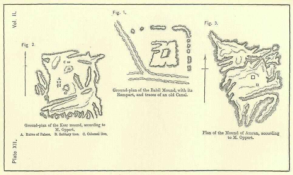
Below the Babil mound, which stands isolated from the rest of the ruins, are two principal masses—the more northern known to the Arabs as EL KASR, "the Palace," and the more southern as "the mound of Amran," from the tomb of a reputed prophet Amran-ibn-Ali, which crowns its summit. The Kasr mound is an oblong square, about 700 yards long by 600 broad, with the sides facing the cardinal points. [PLATE XII., Fig. 2.] Its height above the plain is 70 feet. Its longer direction is from north to south. As far as it has been penetrated, it consists mainly of rubbish-loose bricks, tiles, and fragments of stone. In a few places only are there undisturbed remains of building. One such relic is a subterranean passage, seven feet in height, floored and walled with baked brick, and covered in at the top with great blocks of sandstone, which may either have been a secret exit or more probably an enormous drain. Another is the Kasr, or "palace" proper, whence the mound has its name. This is a fragment of excellent brick masonry in a wonderful state of preservation, consisting of walls, piers, and buttresses, and in places ornamented with pilasters, but of too fragmentary a character to furnish the modern inquirer with any clue to the original plan of the building. The bricks are of a pale yellow color and of the best possible quality, nearly resembling our fire-bricks. They are stamped, one and all, with the name and titles of Nebuchadnezzar. The mortar in which they are laid is a fine lime cement, which adheres so closely to the bricks that it is difficult to obtain a specimen entire. In the dust at the foot of the walls are numerous fragments of brick, painted, and covered with a thick enamel or glaze. Here, too, have been found a few fragments of sculptured stone, and slabs containing an account of the erection of a palatial edifice by Nebuchadnezzar. Near the northern edge of the mound, and about midway in its breadth, is a colossal figure of a lion, rudely carved in black basalt, standing over the prostrate figure of a man with arms outstretched. A single tree grows on the huge ruin, which the Arabs declare to be of a species not known elsewhere, and regard as a remnant of the hanging garden of Bokht-i-nazar. It is a tamarisk of no rare kind, but of very great ago, in consequence of which, and of its exposed position, the growth and foliage are somewhat peculiar.
South of the Kasr mound, at the distance of about 800 yards, is the remaining great mass of ruins, the mound of Jumjuma, or of Amran. [PLATE XII., Fig. 3.] The general shape of this mound is triangular,107 but it is very irregular and ill-defined, so as scarcely to admit of accurate description. Its three sides face respectively a little east of north, a little south of east, and a little south of west. The south-western side, which runs nearly parallel with the Euphrates, and seems to have been once washed by the river, is longer than either of the others, extending a distance of above a thousand yards, while the south-eastern may be 800 yards, and the north-eastern 700. Innumerable ravines traverse the mound on every side, penetrating it nearly to its centre. The surface is a series of undulations. Neither masonry nor sculpture is anywhere apparent.
All that meets the eye is a mass of debris; and the researches hitherto made have failed to bring to light any distinct traces of building. Occasionally bricks are found, generally of poor material, and bearing the names and titles of some of the earlier Babylonian monarchs; but the trenches opened in the pile have in no case laid bare even the smallest fragment of a wall.
Besides the remains which have been already described, the most remarkable are certain long lines of rampart on both sides of the river, which lie outside of the other ruins, enclosing them all, except the mound of Babil. On the left bank of the stream there is to be traced, in the first place, a double line of wall or rampart, having a direction nearly due north and south, which lies east of the Kasr and Amran mounds, at the distance from them of about 1000 yards. Beyond this is a single line of rampart to the north-east, traceable for about two miles, the direction of which is nearly from north-west to south-east, and a double line of rampart to the south-east, traceable for a mile and a half, with a direction from northeast to south-west. The two lines in this last case are from 600 to 700 yards apart, and diverge from one another as they run out to the north-east. The inner of the two meets the north-eastern rampart nearly at a right angle, and is clearly a part of the same work. It is questioned, however, whether this line of fortification is ancient, and not rather a construction belonging to Parthian times.
A low line of mounds is traceable between the western face of the Amran and Kasr hills, and the present eastern bank of the river, bounding a sort of narrow valley, in which either the main stream of the Euphrates, or at any rate a branch from it, seems anciently to have flowed.
On the right bank of the stream the chief remains are of the same kind. West of the river, a rampart, twenty feet high, runs for nearly a mile parallel with the general line of the Amran mound, at the distance of about 1000 yards from the old course of the stream. At either extremity the line of the rampart turns at a right angle, running down towards the river, and being traceable towards the north for 400 yards and towards the south for fifty or sixty. It is evident that there was once, before the stream flowed in its present channel, a rectangular enclosure, a mile long and 1000 yards broad, opposite to the Amran mound; and there are indications that within this enceinte was at least one important building, which was situated near the south-east angle of the enclosure, on the banks of the old course of the river. The bricks found at this point bear the name of Neriglissar.
There are also, besides the ramparts and the great masses of ruin above described, a vast number of scattered and irregular heaps of hillocks on both sides of the river, chiefly, however, upon the eastern bank. Of these one only seems to deserve distinct mention. This is the mound called El Homeira, "the Red," which lies due east of the Kasr, distant from it about 800 yards—a mound said to be 300 yards long by 100 wide, and to attain an elevation of 60 or 70 feet. It is composed of baked brick of a bright red color, and must have been a building of a very considerable height resting upon a somewhat confined base. Its bricks are inscribed along their edges, not (as is the usual practice) on their lower face.
The only other ancient work of any importance of which some remains are still to be traced is a brick embankment on the left bank of the stream between the Kasr and the Babil mounds, extending for a distance of a thousand yards in a line which has a slight curve and a general direction of S.S.W. The bricks of this embankment are of a bright red color, and of great hardness. They are laid wholly in bitumen. The legend which they bear shows that the quay was constructed by Nabonidus. [PLATE XIII.]
Such then are the ruins of Babylon—the whole that can now with certainty be assigned to the "beauty of the Chaldees' excellency"—the "great Babylon" of Nebuchadnezzar. Within a space little more than three miles long and a mile and three quarters broad are contained all the undoubted remains of the greatest city of the old world. These remains, however, do not serve in any way to define the ancient limits of the place. They are surrounded on every side by nitrous soil, and by low heaps which it has not been thought worth while to excavate, but which the best judges assign to the same era as the great mounds, and believe to mark the sites of the lesser temples and the other public buildings of the ancient city. Masses of this kind are most frequent to the north and east. Sometimes they are almost continuous for miles; and if we take the Kasr mound as a centre, and mark about it an area extending five miles in each direction (which would give a city of the size described by Ctesias and the historians of Alexander), we shall scarcely find a single square mile of the hundred without some indications of ancient buildings upon its surface. The case is not like that of Nineveh, where outside the walls the country is for a considerable distance singularly bare of ruins. The mass of Babylonian remains extending from Babil to Amran does not correspond to the whole enceinte of Nineveh, but to the mound of Koyunjik. It has every appearance of being, not the city, but "the heart of the city"—the "Royal quarter" outside of which were the streets and squares, and still further off, the vanished walls. It may seem strange that the southern capital should have so greatly exceeded the dimensions of the northern one. But, if we follow the indications presented by the respective sites, we are obliged to conclude that there was really this remarkable difference.
It has to be considered in conclusion how far we can identify the various ruins above described with the known buildings of the ancient capital, and to what extent it is possible to reconstruct upon the existing remains the true plan of the city. Fancy, if it discards the guidance of fact, may of course with the greatest ease compose plans of a charming completeness. A rigid adherence to existing data will produce, it is to be feared, a somewhat meagre and fragmentary result; but most persons will feel that this is one of the cases where the maxim of Hesiod applies—"the half is preferable to the whole:"
The one identification which may be made upon certain and indeed indisputable evidence is that of the Kasr mound with the palace built by Nebuchadnezzar. The tradition which has attached the name of Kasr or "Palace" to this heap is confirmed by inscriptions upon slabs found on the spot, wherein Nebuchadnezzar declares the building to be his "Grand Palace." The bricks of that part of the ruin which remains uncovered bear, one and all, the name of this king; and it is thus clear that here stood in ancient times the great work of which Berosus speaks as remarkable for its height and splendor. If a confirmation of the fact were needed after evidence of so decisive a character, it would be found in the correspondence between the remains found on the mound and the description left us of the "greater palace" by Diodorus. Diodorus relates that the walls of this edifice were adorned with colored representations of hunting scenes; and modern explorers find that the whole soil of the mound, and especially the part on which the fragment of ruin stands, is full of broken pieces of enamelled brick, varied in hue, and evidently containing portions of human and animal forms.
But if the Kasr represents the palace built by Nebuchadnezzar, as is generally allowed by those who have devoted their attention to the subject, it seems to follow almost as a certainty that the Amran mound is the site of that old palatial edifice to which the erection of Nebuchadnezzar was an addition. Berosus expressly states that Nebuchadnezzar's building "adjoined upon" the former palace, a description which is fairly applicable to the Amran mound by means of a certain latitude of interpretation, but which is wholly inapplicable to any of the other ruins. This argument would be conclusive, even if it stood alone. It has, however, received an important corroboration in the course of recent researches. From the Amran mound, and from this part of Babylon only, have monuments been recovered of an earlier date than Nebuchadnezzar. Here and here alone did the early kings leave memorials of their presence in Babylon; and here consequently, we may presume, stood the ancient royal residence.
If, then, all the principal ruins on the east bank of the river, with the exception of the Babil mound and the long lines marking walls or embankments, be accepted as representing the "great palace" or "citadel" of the classical writers we must recognize in the remains west of the ancient course of the river-the oblong square enclosure and the important building at its south-east angle—the second or "smaller palace" of Ctesias, which was joined to the larger one, according to that writer, by a bridge and a tunnel. This edifice, built or at any rate repaired by Neriglissar, lay directly opposite the more ancient part of the eastern palace, being separated from it by the river, which anciently flowed along the western face of the Kasr and Amran mounds. The exact position of the bridge cannot be fixed. With regard to the tunnel, it is extremely unlikely that any such construction was ever made. The "Father of History" is wholly silent on the subject, while he carefully describes the bridge, a work far less extraordinary. The tunnel rests on the authority of two writers only—Diodorus and Philostratus—who both wrote after Babylon was completely ruined. It was probably one of the imaginations of the inventive Ctesias, from whom Diodorus evidently derived all the main points of his description.
Thus far there is no great difficulty in identifying the existing remains with buildings mentioned by ancient authors; but, at the point to which we are now come, the subject grows exceedingly obscure, and it is impossible to offer more than reasonable conjectures upon the true character of the remaining ruins. The descriptions of ancient writers would lead us to expect that we should find among the ruins unmistakable traces of the great temple of Belus, and at least some indication of the position occupied by the Hanging Gardens. These two famous constructions can scarcely, one would think, have wholly perished. More especially, the Belus temple, which was a stade square, and (according to some) a stade in height, must almost of necessity have a representative among the existing remains. This, indeed, is admitted on all hands; and the controversy is thereby narrowed to the question, which of two great ruins—the only two entitled by their size and situation to attention—has the better right to be regarded as the great and celebrated sanctuary of the ancient Babylon.
That the mound of Babil is the ziggurat or tower of a Babylonian temple scarcely admits of a doubt. Its square shape, its solid construction, its isolated grandeur, its careful emplacement with the sides facing the cardinal points, and its close resemblance to other known Babylonian temple-towers, sufficiently mark it for a building of this character, or at any rate raise a presumption which it would require very strong reasons indeed to overcome. Its size moreover corresponds well with the accounts which have come down to us of the dimensions of the Belus temple, and its name and proximity to the other main ruins show that it belonged certainly to the ancient capital. Against its claim to be regarded as the remains of the temple of Bolus two objections only can be argued: these are the absence of any appearance of stages, or even of a pyramidical shape, from the present ruin, and its position on the same side of the Euphrates with the palace. Herodotus expressly declares that the temple of Belus and the royal palace were upon opposite sides of the river, and states, moreover, that the temple was built in stages, which rose one above the other to the number of eight. Now these two circumstances, which do not belong at present to the Babil mound, attach to a ruin distant from it about eleven or twelve miles—a ruin which is certainly one of the most remarkable in the whole country, and which, if Babylon had really been of the size asserted by Herodotus, might possibly have been included within the walls. The Birs-i-Nimrud had certainly seven, probably eight stages, and it is the only ruin on the present western bank of the Euphrates which is at once sufficiently grand to answer to the descriptions of the Belus temple, and sufficiently near to the other ruin to make its original inclusion within the walls not absolutely impossible. Hence, ever since the attention of scholars was first directed to the subject of Babylonian topography, opinion has been divided on the question before us, and there have not been wanting persons to maintain that the Birs-i-Nimrud is the true temple of Belus, if not also the actual tower of Babel, whose erection led to the confusion of tongues and general dispersion of the sons of Adam.
With this latter identification we are not in the present place concerned. With respect to the view that the Birs is the sanctury of Belus, it may be observed in the first place that the size of the building is very much smaller than that ascribed to the Belus temple; secondly, that it was dedicated to Kebo, who cannot be identified with Bel; and thirdly, that it is not really any part of the remains of the ancient capital, but belongs to an entirely distinct town. The cylinders found in the ruin by Sir Henry Eawlinson declare the building to have been "the wonder of Borsippa;" and Borsippa, according to all the ancient authorities, was a town by itself—an entirely distinct place from Babylon. To include Borsippa within the outer wall of Babylon is to run counter to all the authorities on the subject, the inscriptions, the native writer, Berosus, and the classical geographers generally. Nor is the position thus assigned to the Belus temple in harmony with the statement of Herodotus, which alone causes explorers to seek for the temple on the west side of the river. For, though the expression which this writer uses does not necessarily mean that the temple was in the exact centre of one of the two divisions of the town, it certainly implies that it lay towards the middle of one division—well within it—and not upon its outskirts. It is indeed inconceivable that the main sanctuary of the place, where the kings constantly offered their worship, should have been nine or ten miles from the palace! The distance between the Amran mound and Babil, which is about two miles, is quite as great as probability will allow us to believe existed between the old residence of the kings and the sacred shrine to which they were in the constant habit of resorting.
Still there remain as objections to the identification of the great temple with the Babil mound the two arguments already noticed. The Babil mound has no appearance of stages such as the Birs presents, nor has it even a pyramidical shape. It is a huge platform with a nearly level top, and sinks, rather than rises, in the centre. What has become, it is asked, of the seven upper stages of the great Belus tower, if this ruin represents it? Whither have they vanished? How is it that in crumbling down they have not left something like a heap towards the middle? To this it may be replied that the destruction of the Belus tower has not been the mere work of the elements—it was violently broken down either by Xerxes, or by some later king, who may have completely removed all the upper stages. Again, it has served as a quarry to the hunters after bricks for more than twenty centuries; so that it is only surprising that it still retains so much of its original shape. Further, when Alexander entered Babylon more than 2000 years ago 10,000 men were employed for several weeks in clearing away the rubbish and laying bare the foundations of the building. It is quite possible that a conical mass of crumbled brick may have been removed from the top of the mound at this time.
The difficulty remains that the Babil mound is on the same side of the Euphrates with the ruins of the Great Palace, whereas Herodotus makes the two buildings balance each other, one on the right and the other on the left bank of the stream. Now here it is in the first place to be observed that Herodotus is the only writer who does this. No other ancient author tells us anything of the relative situation of the two buildings. We have thus nothing to explain but the bald statement of a single writer—a writer no doubt of great authority, but still one not wholly infallible. We might say, then, that Herodotus probably made a mistake—that his memory failed him in this instance, or that he mistook his notes on the subject. Or we may explain his error by supposing that he confounded a canal from the Euphrates, which seems to have anciently passed between the Babil mound and the Kasr (called Shebil by Nebuchadnezzar) with the main stream. Or, finally, we may conceive that at the time of his visit the old palace lay in ruins, and that the palace of Nerig-lissar on the west bank of the stream was that of which he spoke. It is at any rate remarkable, considering how his authority is quoted as fixing the site of the Belus tower to the west bank, that, in the only place where he gives us any intimation of the side of the river on which he would have placed the tower, it is the east and not the west bank to which his words point. He makes those who saw the treachery of Zopyrus at the Belian and Kissian gates, which must have been to the east of the city, at once take refuge in the famous sanctuary, which he implies was in the vicinity.
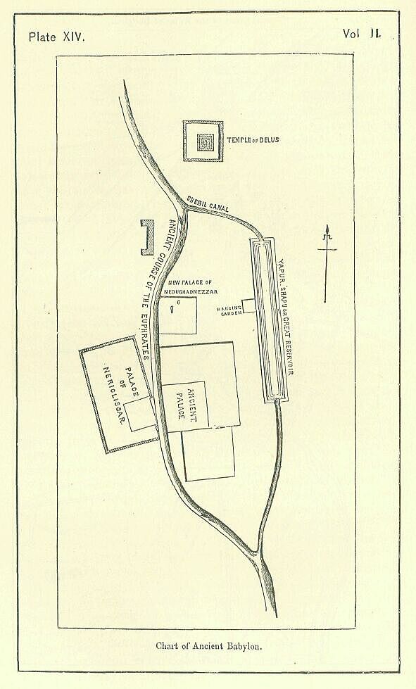
On the whole, therefore, it seems best to regard the Babil mound as the ziggurat of the great temple of Bel (called by some "the tomb of Belus") which the Persians destroyed and which Alexander intended to restore. With regard to the "hanging gardens," as they were an erection of less than half the size of the tower, it is not so necessary to suppose that distinct traces must remain of them. Their debris may be confused with those of the Kasr mound, on which one writer places them. Or they may have stood between the Kasr and Amran ruins, where are now some mounds of no great height. Or, possibly, their true site is in the modern El Homeira, the remarkable red mound which lies east of the Kasr at the distance of about 800 yards, and attains an elevation of sixty-five feet. Though this building is not situated upon the banks of the Euphrates, where Strabo and Diodorus place the gardens, it abuts upon a long low valley into which the Euphrates water seems formerly to have been introduced, and which may therefore have been given the name of the river. This identification is, however, it must be allowed, very doubtful.
The two lines of mounds which enclose the long low valley above mentioned are probably the remains of an embankment which here confined the waters of a great reservoir. Nebuchadnezzar relates that he constructed a large reservoir, which he calls the Yapur-Shapu, in Babylon, and led water into it by means of an "eastern canal"—the Shebil. The Shebil canal, it is probable, left the Euphrates at some point between Babil and the Kasr, and ran across with a course nearly from west to east to the top of the Yapur-Shapu. This reservoir seems to have been a long and somewhat narrow parallelogram, running nearly from north to south, which shut in the great palace on the east and protected it like a huge moat. Most likely it communicated with the Euphrates towards the south by a second canal, the exact line of which cannot be determined. Thus the palatial residence of the Babylonian kings looked in both directions upon broad sheets of water, an agreeable prospect in so hot a climate; while, at the same time, by the assignment of a double channel to the Euphrates, its floods were the more readily controlled, and the city was preserved from those terrible inundations which in modern times have often threatened the existence of Baghdad.
The other lines of mound upon the east side of the river may either be Parthian works, or (possibly) they may be the remains of some of those lofty walls whereby, according to Diodorus, the greater palace was surrounded and defended. The fragments of them which remain are so placed that if the lines were produced they would include all the principal ruins on the left bank except the Babil tower. They may therefore be the old defences of the Eastern palace; though, if so, it is strange that they run in lines which are neither straight nor parallel to those of the buildings enclosed by them. The irregularity of these ramparts is certainly a very strong argument in favor of their having been the work of a people considerably more barbarous and ignorant than the Babylonians. [PLATE XIV.]