| CHAPTER I. | EXTENT OF THE EMPIRE. |
| CHAPTER II. | CLIMATE AND PRODUCTIONS. |
| CHAPTER III. | CHARACTER, MANNERS AND CUSTOMS. |
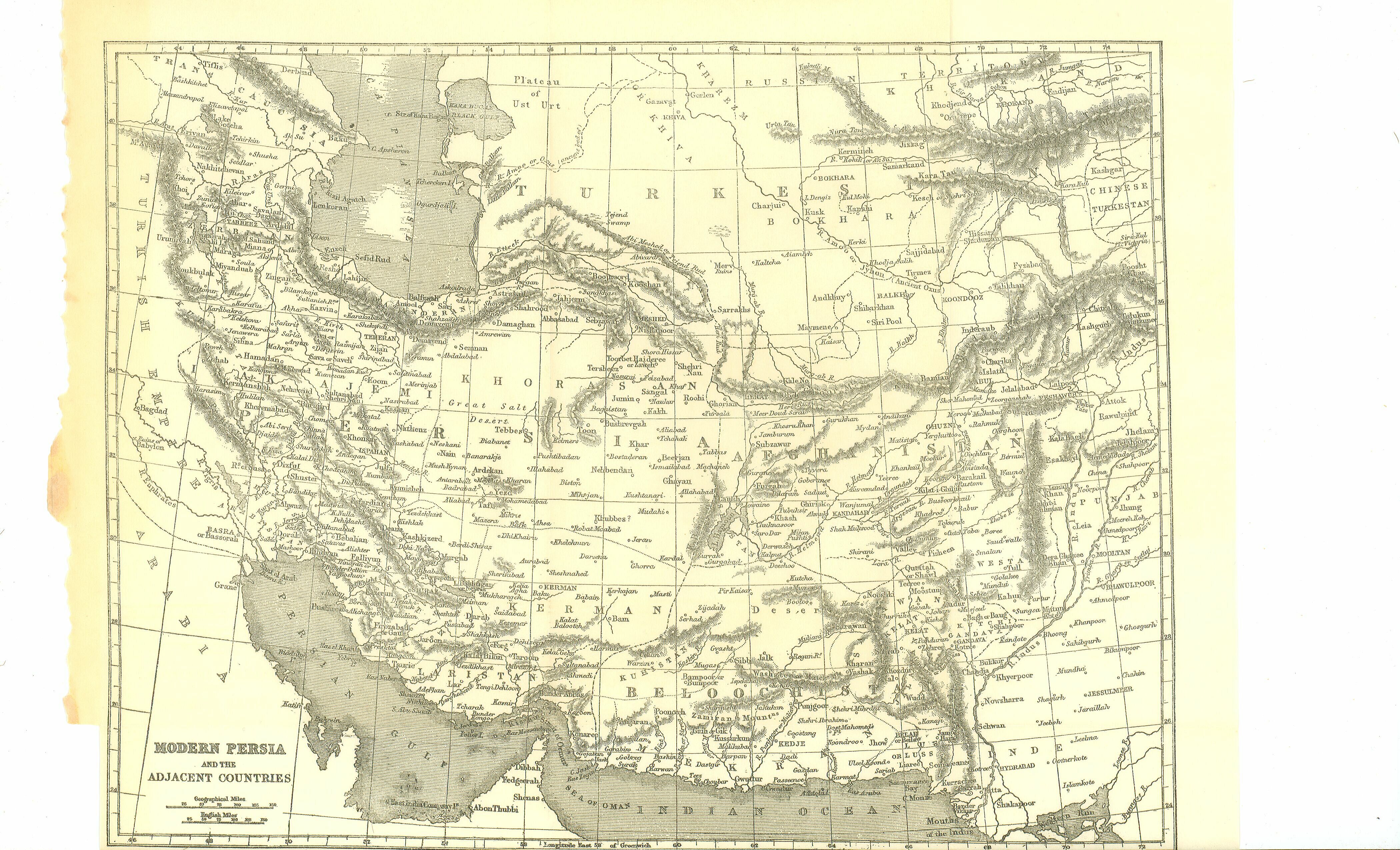
The geographical extent of the Fifth Monarchy was far greater than that of any one of the four which had preceded it. While Persia Proper is a comparatively narrow and poor tract, extending in its greatest length only some seven or eight degrees (less than 500 miles), the dominions of the Persian kings covered a space fifty-six degrees long, and in places more than twenty degrees wide. The boundaries of their empire were the desert of Thibet, the Sutlej, and the Indus, on the east; the Indian Sea, the Persian Gulf, the Arabian and Nubian deserts, on the south; on the west, the Greater Syrtis, the Mediterranean, the Egean, and the Strymon river; on the north, the Danube, the Black Sea, the Caucasus, the Caspian, and the Jaxartes. Within these limits lay a territory, the extent of which from east to west was little less than 3000 miles, while its width varied between 500 and 1500 miles. Its entire area was probably not less than, two millions of square miles—or more than half that of modern Europe. It was thus at least eight times as large as the Babylonian Empire at its greatest extent, and was probably more than four times as large as the Assyrian.
The provinces included within the Empire may be conveniently divided into the Central, the Western, and the Eastern. The Central are Persia Proper, Susiana, Babylonia, Assyria, Media, the coast tract of the Caspian, and Sagartia, or the Great Desert. The Western are Paeonia, Thrace, Asia Minor, Armenia, Iberia, Syria and Phoenicia, Palestine, Egypt, and the Cyrenaica. The Eastern are Hyrcania, Parthia, Aria, Chorasmia, Sogdiana, Bactria, Scythia, Gandaria, Sattagydia, India, Paricania, the Eastern AEthiopia, and Mycia.
Of these countries a considerable number have been already described in these volumes. Susiana, Babylonia, Assyria, Media, the Caspian coast, Armenia, Syria, Phoenicia, and Palestine, belong to this class; and it may be assumed that the reader is sufficiently acquainted with their general features. It would therefore seem to be enough in the present place to give an account of the regions which have not yet occupied our attention, more especially of Persia Proper—the home of the dominant race.
Persia Proper seems to have corresponded nearly to that province of the modern Iran, which still bears the ancient name slightly modified, being called Farsistan or Fars. The chief important difference between the two is, that whereas in modern times the tract called Herman is regarded as a distinct and separate region, Carmania anciently was included within the limits of Persia. Persia Proper lay upon the gulf to which it has given name, extending from the mouth of the Tab (Oroatis) to the point where the gulf joins the Indian Ocean. It was bounded on the west by Susiana, on the north by Media Magna, on the east by Mycia, and on the south by the sea. Its length seems to have been about 450, and its average width about 250 miles. It thus contained an area of rather more than 100,000 square miles.
In modern times it is customary to divide the province of Fars into the ghermsir, or, "warm district," and the serdsir, or "cold region"—and the physical character of the country must have made such a division thoroughly appropriate at every period. The "warm district" is a tract of sandy plain, often impregnated with salt, which extends between the mountains and the sea the whole length of the province, being a continuation of the flat region of Susiana, but falling very much short of that region in all the qualities which constitute physical excellence. The soil is poor, consisting of alternate sand and clay—it is ill-watered, the entire tract possessing scarcely a single stream worthy of the name of river—and, lying only just without the northern Tropic, the district is by its very situation among the hottest of western Asia. It forms, however, no very large portion of the ancient Persia, being in general a mere strip of land, from ten to fifty miles wide, and thus not constituting more than an eighth part of the territory in question.
The remaining seven eighths belong to the serdsir, or "cold region." The mountain-range which under various names skirts on the east the Mesopotamian lowland, separating off that depressed and generally fertile region from the bare high plateau of Iran, and running continuously in a direction parallel to the course of the Mesopotamian streams—i.e. from the north-west to the south-east—changes its course as it approaches the sea, sweeping gradually round between long. 50° and 55°, and becoming parallel to the coast-line, while at the same time it broadens out, till it covers a space of nearly three degrees, or above two hundred miles. Along the high tract thus created lay the bulk of the ancient Persia, consisting of alternate mountain, plain, and narrow valley, curiously intermixed, and as yet very incompletely mapped. This region is of varied character. In places richly, fertile, picturesque, and romantic almost beyond imagination, with lovely wooded dells, green mountain-sides, and broad plains suited for the production of almost any crops, it has yet on the whole a predominant character of sterility and barrenness, especially towards its more northern and eastern portions. The supply of water is everywhere scanty. Scarcely any of the streams are strong enough to reach the sea. After short courses they are either absorbed by the sand or end in small salt lakes, from which the superfluous water is evaporated. Much of the country is absolutely without streams, and would be uninhabitable were it not for the kanats, or karizes, subterranean channels of spring-water, described at length in a former volume.
The only rivers of the district which deserve any attention are the Tab (or Oroatis), whereof a description has been already given, the Kur or Bendamir (called anciently Araxes), with its tributary, the Pulwar (or Cyrus), and the Khoonazaberni or river of Khisht.
The Bendamir rises in the mountains of the Bakhtiyari chain, in lat. 30° 35', long. 51° 50' nearly, and runs with a course which is generally south-east, past the ruins of Persepolis, to the salt lake of Neyriz or Kheir, which it enters in long. 53° 30'. It receives, where it approaches nearest to Persepolis, the Pulwar or Kur-ab, a small stream coming from the north-east and flowing by the ruins of both Pasargadae and Persepolis. A little below its junction with this stream the Bendamir is crossed by a bridge of five arches, and further down, on the route between Shiraz and Herman, by another of twelve. Here its waters are to a great extent drawn off by means of canals, and are made to fertilize a large tract of rich flat country on either bank, after which the stream pursues its course with greatly diminished volume to the salt lake in which it ends. The entire course, including only main windings, may be estimated at 140 or 150 miles.
The Khoonazaberni or river of Khisht rises near the ruins of Shapur, at a short distance from Kazerun, on the route between Bushire and Shiraz, and flows in a broad valley between lofty mountains towards the south-west, entering the Persian Gulf by three mouths, the chief of which is at Rohilla, twenty miles north of Bushire, where the stream has a breadth of sixty yards, and a depth of about four feet. Above Khisht the river is already thirty yards wide. Its chief tributary is the Dalaki stream, which enters it from the east, nearly in long. 51°. The entire course of the Khisht river may be about 95 or 100 miles. Its water is brackish except near the source.
The principal lakes are the Lake of Neyriz and the Deriah-i-Nemek. The Deriah-i-Nemek is a small basin distant about ten miles from Shiraz, which receives the waters of the streams that supply that town. It has a length of about fifteen and a breadth of about three or three and a half miles. The lake of Neyriz or Kheir is of far larger size, being from fifty to sixty miles long and from three to six broad, though in the summer season it is almost entirely dried up. Salt is then obtained from the lake in large quantities, and forms an important feature in the commerce of the district. Smaller lakes, also salt or brackish, exist in other parts of the country, as Lake Famur, near Kazerun, which is about six miles in length, and from half a mile to a mile across.
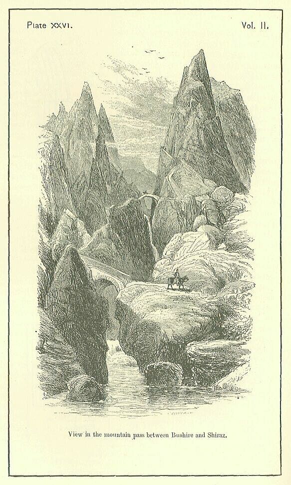
The most remarkable feature of the country consists in the extraordinary gorges which pierce the great mountain-chain, and render possible the establishment of routes across that tremendous barrier. Scarped rocks rise almost perpendicularly on either side of the mountain-streams, which descend rapidly with frequent cascades and falls. Along the slight irregularities of these rocks the roads are carried in zigzags, often crossing the streams from side to side by bridges of a single arch, which are thrown over profound chasms where the waters chafe and roar many hundred feet below. [PLATE XXVI.] The roads have for the most part been artificially cut in the sides of the precipices, which rise from the streams sometimes to the height of 2000 feet. In order to cross from the Persian Gulf to the high plateau of Iran, no fewer than three or four of these kotuls, or strange gorge-passes, have to be traversed successively. Thus the country towards the edge of the plateau is peculiarly safe from attack, being defended on the north and east by vast deserts, and on the south by a mountain-barrier of unusual strength and difficulty.
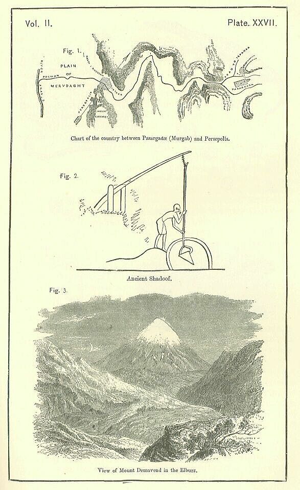
It is in these regions, which combine facility of defence with pleasantness of climate, that the principal cities of the district have at all times been placed. The earliest known capital of the region was Pasargadae, or Persagadae, as the name is sometimes written, of which the ruins still exist near Murgab, in lat. 30° 15' long. 53° 17'. Here is the famous tomb of Cyrus, whereof a description will be given hereafter; and here are also other interesting remains of the old Persian architecture. Neither the shape nor the extent of the town can be traced. The situation was a plain amid mountains, watered by small streams which found their way to a river of some size (the Pulwar) flowing at a little distance to the west. [PLATE XXVII Fig. 1.]
At the distance of thirty miles from Pasargadae, or of more than forty by the ordinary road, grew up the second capital, Persepolis, occupying a more southern position than the primitive seat of power, but still situated towards the edge of the plateau, having the mountain-barrier to the south-west and the desert at no great distance to the north-east. Like its predecessor, Persepolis was situated in a plain, but in a plain of much larger dimensions and of far greater fertility. The plain of Merdasht is one of the most productive in Persia, being watered by the two streams of the Bendamir and the Pulwar, which unite a few miles below the site of the ancient city. From these two copious and unfailing rivers a plentiful supply of the precious fluid can at all times be obtained; and in Persia such a supply will always create the loveliest verdure, the most abundant crops, and the richest and thickest foliage. The site of Persopolis is naturally far superior to that in which the modern provincial capital, Shiraz, has grown up, at about the same distance from Persepolis as that is from Pasargadae. and in the same—i.e. in a south-west—direction.
Besides Persepolis and Pasargadse, Persia Proper contained but few cities of any note or name. If we include Carmania in Persia, Carmana, the capital of that country, may indeed be mentioned as a third Persian town of some consequence; but otherwise the names which occur in ancient authors are insignificant, and designate villages rather than towns of any size. Carmana, however, which is mentioned by Ptolemy and Ammianus as the capital of those parts, seems to have been a place of considerable importance. It may be identified with the modern Kerman, which lies in lat. 39° 55', long. 56° 13', and is still one of the chief cities of Persia. Situated, like Pasargadae and Persepolis, in a capacious plain surrounded by mountains, which furnish sufficient water for cultivation to be carried on by means of kanats in most parts of the tract enclosed by them, and occupying a site through which the trade of the country almost of necessity passes, Kerman must always be a town of no little consequence. Its inland and remote position, however, caused it to be little known to the Greeks; and, apparently, the great Alexandrian geographer was the first who made them acquainted with its existence and locality.
The Persian towns or villages upon the coast of the Gulf were chiefly Armuza (which gave name to the district of Ar-muzia), opposite the modern island of Ormuz; Sisidona, which must have been near Cape Jerd; Apostana, probably about Shewar; Gogana, no doubt the modern Kongoon; and Taoce on the Granis, famous as having in its neighborhood a royal palace, which we may perhaps place near Dalaki, Taoce itself occupying the position of Rohilla, at the mouth of the Khisht river. Of the inland towns the most remarkable, after Persepolis, Pasargadse, and Carmana, were Gabae, near Pasar-gadae, also the site of a palace; Uxia, or the Uxian city, which may have occupied the position of Mai-Amir, Obroatis, Tragonice, Ardea, Portospana, Hyrba, etc., which it is impossible to locate unless by the merest conjecture.
The chief districts into which the territory was divided were Paraetacene, a portion of the Bakhtiyari mountain-chain, which some, however, reckoned to Media; Mardyene, or the country of the Mardi, also one of the hill tracts; Taocene, the district about Taoce, part of the low sandy coast region; Ciribo, the more northern portion of the same region; and Carmania, the entire eastern territory. These districts were not divided from one another by any marked natural features, the only division of the country to which such a character attached being the triple one into the high sandy plains north of the mountains, the mountain region, and the Deshtistan, or low hot tract along the coast.
From this account it will be easy to understand how Persia Proper acquired and maintained the character of "a scant land and a rugged," which we find attaching to it in ancient authors. The entire area, as has been already observed was about 100,000 square miles—little more than half that of Spain, and about one fifth of the area of modern Persia. Even of this space nearly one half was uninhabitable, consisting either of barren stony mountain or of scorching sandy plain, ill supplied with water, and often impregnated with salt, the habitable portion consisted of the valleys and plains among the mountains and along their skirts, together with certain favored spots upon the banks of streams in the flat regions. These flat regions themselves were traversed in many places by rocky ridges of a singularly forbidding aspect. The whole appearance of the country was dry, stony, sterile. As a modern writer observes, "the livery of the land is constantly brown or gray; water is scanty; plains and mountains are equally destitute of wood. When the traveller, after toiling over the rocky mountains that separate the plains looks down from the pass he has won with toil and difficulty upon the country below, his eye wanders unchecked and unrested over an uniform brown expanse losing itself in distance."
Still this character, though predominant, is not universal. Wherever there is water, vegetation springs up. The whole of the mountain region is intersected by valleys and plains which are more or less fertile. The line of country between Bebahan and Shiraz is for above sixty miles "covered with wood and verdure," in East of Shiraz, on the route between that city and Kerman the country is said to be in parts "picturesque and romantic," consisting of "low luxuriant valleys or; plains separated by ranges of low mountains, green to their very summits with beautiful turf." The plains of Khubbes, Merdasht, Ujan, Shiraz, Kazerun, and others, produce abundantly under a very inefficient system of cultivation. Even in the most arid tracts there is generally a time of greenness immediately after the spring rains, when the whole country smiles with verdure.
It has been already remarked that the Empire, which, commencing from Persia Proper, spread itself towards the close of the sixth century before Christ, over the surrounding tracts, included a number of countries not yet described in these volumes, since they formed no part of any of the four Empires which preceded the Persian. To complete, therefore, the geographical survey proper to our subject, it will be necessary to give a sketch of the tracts in question. They will fall naturally into three groups, an eastern, a north-western, and a southwestern—the eastern extending from the skirts of Mount Zagros to the Indian Desert, the north-western from the Caspian to the Propontis, and the south-western from the borders of Palestine to the shores of the Greater Syrtis.
Inside the Zagros and Elburz ranges, bounded on the north and west by those mountain-lines, on the east by the ranges of Suliman and Hala, and on the south by the coast-chain which runs from Persia Proper nearly to the Indus, lies a vast tableland, from 3000 to 5000 feet above the sea-level, known to modern geographers as the Great Plateau of Iran. Its shape is an irregular rectangle, or trapezium, extending in its greatest length, which is from west to east, no less than twenty degrees, or above 1100 miles, while the breadth from north to south varies from seven degrees, or 480 miles (which is its measure along the line of Zagros), to ten degrees, or 690 miles, where it abuts upon the Indus valley. The area of the tract is probably from 500,000 to 600,000 square miles.
It is calculated that two thirds of this elevated region are absolutely and entirely desert. The rivers which flow from the mountains surrounding it are, with a single exception—that of the Etymandrus or Helmend—insignificant, and their waters almost always lose themselves, after a course proportioned to their volume, in the sands of the interior. Only two, the Helmend and the river of Ghuzni, have even the strength to form lakes; the others are absorbed by irrigation, or sucked up by the desert. Occasionally a river, rising within the mountains, forces its way through the barrier, and so contrives to reach the sea. This is the case, especially, on the south, where the coast chain is pierced by a number of streams, some of which have their sources at a considerable distance inland. On the north the Heri-rud, or River of Herat, makes its escape in a similar way from the plateau, but only to be absorbed, after passing through two mountain chains, in the sands of the Kharesm. Thus by far the greater portion of this region is desert throughout the year, while, as the summer advances, large tracts, which in the spring were green, are burnt up—the rivers shrink back towards their sources—the whole plateau becomes dry and parched—and the traveller wonders that any portion of it should be inhabited.
It must not be supposed that the entire plateau of which we have been speaking is to the eye a single level and unbroken plain. In the western portion of the region the plains are constantly intersected by "brown, irregular, rocky ridges," rising to no great height, but serving to condense the vapors held in the air, and furnishing thereby springs and wells of inestimable value to the inhabitants. In the southern and eastern districts "immense" ranges of mountains are said to occur; and the south-eastern as well as the north-eastern corners of the plateau are little else than confused masses of giant elevations. Vast flats, however, are found. In the Great Salt Desert, which extends from Kashan and Koum to the Deriah or "Sea" in which the Helmend terminates, and in the sandy desert of Seistan, which lies east and south-east of that lake, reaching from near Furrah to the Mekran mountains, plains of above a hundred miles in extent appear to occur, sometimes formed of loose sand, which the wind raises into waves like those of the sea, sometimes hard and gravelly, or of baked and indurated clay.
The tract in question, which at the present day is divided between Afghanistan, Beloochistan, and Iran, contained, at the time when the Persian Empire arose, the following nations: the Sagartians, the Cossseans, the Parthians, the Hariva or Arians, the Gandarians, the Sattagydians, the Arachotians, the Thamanseans, the Sarangae, and the Paricanians. The Sagartians and Cossseans dwelt in the western portion of the tract, the latter probably about the Siah-Koh mountains, the former scattered over the whole region from the borders of Persia Proper to the Caspian Gates and the Elburz range. Along its northern edge, east of the Sagartians, were the Parthians, the Arians, and the Gandarians. occurring in that order as we proceed from west to east. The Parthians held the country known now as the Atak or "Skirt," the flat tract at the southern base of the Elburz from about Shahrud to Khaff, together with a portion of the mountain region adjoining. This is a rich and valuable territory, well watered by a number of small streams, which, issuing from the ravines and valleys of the Elburz, spread fertility around, but lose themselves after a short, course in the Salt Desert. Adjoining the Parthians upon the east were the Haroyu, Hariva, or Arians, an Iranic race of great antiquity, who held the country along the southern skirts of the mountains from the neighborhood of Khaff to the point where the Heri-rud (Arius) issues from the Paropamisan mountains. The character of this country closely resembles that of Parthia, whereof it is a continuation; but the copious stream of the Heri-rud renders it even more productive.
The Gandarians held Kabul, and the mountain tract on both sides of the Kabul river as far as the upper course of the Indus, thus occupying the extreme north-eastern corner of the plateau, the region where its elevation is the greatest. Lofty mountain-ridges, ramifying in various directions but tending generally to run east and west, deep gorges, narrow and tremendous passes, like the Khyber, characterize this district. Its soil is generally rocky and barren; but many of the valleys are fertile, abounding with enchanting scenery and enjoying a delightful climate. More especially is this the case in the neighborhood of the city of Kabul, which is perhaps the Caspatyrus of Herodotus, where Darius built the fleet which descended the Indus.
South of Aria and Gandaria, in the tract between the Great Desert and the Indus valley, the plateau was occupied by four nations—the Thamanseans, the Sarangians, the Sattagydians, and the Arachotians. The Thamanaean country appears to have been that which lies south and south-east of Aria (Herat), reaching from the Haroot-rud or river of Subzawar to the banks of the Helmend about Ghirisk. This is a varied region, consisting on the north and the north-east of several high mountain chains which ramify from a common centre, having between them large tracts of hills and downs, while towards the south and the south-west the country is comparatively low and flat, descending to the level of the desert about the thirty second parallel. Here the Thamanseans were adjoined upon by the Sarangians, who held the land about the lake in which the Helmend terminates—the Seistan of Modern Persia. Seistan is mainly desert. One third of the surface of the soil is composed of moving sands, and the other two thirds of a compact sand, mixed with a little clay, but very rich in vegetable matter. It is traversed by a number of streams, as the Haroot-rud, the river of Furrah, the river of Khash, the Helmend, and others, and is very productive along their banks, which are fertilized by annual inundations; but the country between the streams is for the most part an arid desert.
The Sattagydians and Arachotians divided between them the remainder of Afghanistan, the former probably occupying south-eastern Kabul, from the Ghuzni river and its tributaries to the valley of the Indus, while the latter were located in the modern Candahar, upon the Urghand-ab and Turnuk rivers. The character of these tracts is similar to that of north-western Kabul, but somewhat less rugged and mountainous. Hills and downs alternate with rocky ranges and fairly fertile vales. There is a scantiness of water, but still a certain number of moderate-sized rivers, tolerably well supplied with affluents. The soil, however, is either rocky or sandy; and without a careful system of irrigation great portions of the country remain of necessity barren and unproductive.
The south-eastern corner of the plateau, below the countries of the Sarangians and the Arachotians, was occupied by a people, called Paricanians by Herodotus, perhaps identical with the Gedrosians of later writers. This district, the modern Beloochistan, is still very imperfectly known, but appears to be generally mountainous, to have a singularly barren soil, and to be deficient in rivers. The nomadic life is a necessity in the greater part of the region, which is in few places suitable for cultivation, but has good pastures in the mountains or the plains according to the season of the year. The rivers of the country are for the most part mere torrents, which carry a heavy body of water after rains, but are often absolutely dry for several months in succession. Water, however, is generally obtainable by digging wells in their beds; and the liquid procured in this way suffices, not only for the wants of man and beast, but also for a limited irrigation.
The Great Plateau which has been here described is bordered everywhere, except at its north-eastern and north-western corners, by low regions. On the north the lowland is at first a mere narrow strip intervening between the Elburz range and the Caspian, a strip which has been already described in the account given of the Third Monarchy. Where, however, the Caspian ends, its shore trending away to the northward, there succeeds to this mere strip of territory a broad and ample tract of sandy plain, extending from about the 54th to the 68th degree of east longitude—a distance of 760 miles—and reaching from the 36th to the 50th parallel of north latitude—a distance not much short of a thousand miles! This tract which comprises the modern Khanats of Khiva and Bokhara, together with a considerable piece of Southern Asiatic Russia, is for the most part a huge trackless desert, composed of loose sand, black or red, which the wind heaps up into hills. Scarcely any region on the earth's surface is more desolate. The boundless plain lies stretched before the traveller like an interminable sea, but dead, dull, and motionless. Vegetation, even the most dry and sapless, scarcely exists. For three or four hundred miles together he sees no running stream. Water, salt, slimy, and discolored, lies Occasionally in pools, or is drawn from wells, which yield however only a scanty supply. For anything like a drinkable beverage the traveller has to trust to the skies, which give or withhold their stores with a caprice that is truly tantalizing. Occasionally, but only at long intervals, out of the low sandy region there issues a rocky range, or a plateau of moderate eminence, where the soil is firm, the ground smooth, and vegetation tolerably abundant. The most important of the ranges are the Great and Little Balkan, near the Caspian Sea, between the 39th and 40th parallels, the Khalata and Urta Tagh, north-west, of Bokhara, and the Kukuth; still further to the north-west in latitude 42° nearly. The chief plateau is that of Ust-Urt, between the Caspian and the Sea of Aral, which is perhaps not more than three or four hundred feet above the sandy plain, but is entirely different in character.
This desolate region of low sandy plain would be wholly uninhabitable, were it not for the rivers. Two great streams, the Amoo or Jyhun (anciently the Oxus), and the Sir or Synuti (anciently the Jaxartes), carry their waters across the desert, and pour them into the basin of the Aral. Several others of less volume, as the Murg-ab, or river of Merv, the Abi Meshed or Tejend, the Heri-rud, the river of Maymene, the river of Balkh, the river of Khulm, the Shehri-Sebz, the Ak Su or river of Bokhara, the Kizil Deria, etc., flow down from the high ground into the plain, where their waters either become lost in the sands, or terminate in small salt pools. Along the banks of these streams the soil is fertile, and where irrigation is employed the crops are abundant. In the vicinity of Khiva, at Kermineh on the Bokhara river, at Samarcand, at Balkh—and in a few other places, the vegetation is even luxuriant; gardens, meadows, orchards, and cornfields fringe the river-bank; and the natives see in such favored spots resemblances of Paradise! Often, however, even the river-banks themselves are uncultivated, and the desert creeps up to their very edge; but this is in default, not in spite, of human exertion. A well-managed system of irrigation could, in almost every instance, spread on either side of the streams a broad strip of verdure.
In the time of the Fifth Monarchy, the tract which has been here described was divided among three nations. The region immediately to the east of the Caspian, bounded on the north by the old course of the Oxus and extending eastward to the neighborhood of Merv, though probably not including that city, was Chorasmia, the country of the Chorasmians. Across the Oxus to the north-east was Sogdiana (or Sugd), reaching thence to the Jaxartes, which was the Persian boundary in this direction. South of Sogdiana, divided from it by the Middle and Upper Oxus, was Bactria, the country of the Bakhtars or Bactrians. The territory of this people reached southward to the foot of the Paropamisus, adjoining Chorasmia and Aria on the west, and on the south Sattagydia and Gandaria.
East of the table-land lies the valley of the Indus and its tributaries, at first a broad tract, 350 miles from west to east, but narrowing as it descends, and in places not exceeding sixty or seventy miles, across. The length of the valley is not less than 800 miles. Its area is probably about a hundred thousand square miles. We may best regard it as composed of two very distinct tracts—one the broad triangular plain towards the north, to which, from the fact of its being watered by five main streams, he natives have given the name of Punj-ab, the other the long and comparatively narrow valley of the single Indus river, which, deriving its appellation from that noble stream, is known in modern geography as Sinde. The Punjab, which contains an area of above fifty thousand square miles, is mountainous towards the north, where it adjoins on Kashmeer and Thibet, but soon sinks down into a vast plain, with a soil which is chiefly either sand or clay, immensely productive under irrigation, but tending to become jungle or desert if left without human care. Sinde, or the Indus valley below the Punjab, is a region of even greater fertility. It is watered, not only by the main stream of the Indus, but by a number of branch channels which the river begins to throw off from about the 28th parallel. It includes, on the right bank of the stream, the important tract called Cutchi Gandava, a triangular plain at the foot of the Suliman and Hala ranges, containing about 7000 square miles of land which is all capable of being made into a garden. The soil is here for the most part rich, black, and loamy; water is abundant; and the climate suitable for the growth of all kinds of grain. Below Cutchi Gandava the valley of the Indus is narrow for about a hundred miles, but about Tatta it expands and a vast delta is formed. This is a third triangle, containing above a thousand square miles of the richest alluvium, which is liable however to floods and to vast changes in the river beds, whereby often whole fields are swept away. Much of this tract is moreover low and swampy; the climate is trying; and rice is almost the only product that can be advantageously cultivated.
The low region lying south of the Great Plateau is neither extensive nor valuable. It consists of a mere strip of land along the coast of the Indian Ocean, extending a distance of about nine degrees (550 miles) from the mouth of the Persian Gulf to Cape Monze, near Kurrachee, but in width not exceeding ten or, at the most, twenty miles. This tract was occupied in ancient times mainly by a race which Herodotus called Ethiopians and the historians of Alexander Ichthyophagi (Fish-Eaters). It is an arid, sultry, and unpleasant region, scarcely possessing a perennial stream, and depending for its harvests entirely upon the winter rains, and for its water during the summer on wells which are chiefly brackish. Tolerable pasturage is, however, obtainable in places even during the hottest part of the year, and between Cape Jask and Gwattur the crops produced are far from contemptible.
A small tract of coast, a continuation of the territory just described, intervening between it and Kerman, was occupied in the early Persian times by a race known to the Persians as Maka, and to the Greeks as Mycians. This district, reaching from about Cape Jask to Gombroon, is one of greater fertility than is usual in these regions, being particularly productive in dates and grain. This fertility seems, however, to be confined to the vicinity of the sea-shore.
To complete the description of the Eastern provinces two other tracts must be mentioned. The mountain-chain which skirts the Great Plateau on the north, distinguished in these pages by the name of Elburz, broadens out after it passes the south-eastern corner of the Caspian Sea till it covers a space of nearly three degrees (more than 200 miles). Instead of the single lofty ridge which separates the Salt Desert from the low Caspian region, we find between the fifty-fourth and fifty-ninth degrees of east longitude three or four distinct ranges, all nearly parallel to one another, having a general direction of east and west. Broad and rich valleys are enclosed between these latitudinal ranges which are watered by rivers of a considerable size, as more especially the Ettrek and the Gurgan. Thus a territory is formed capable of supporting a largish population, a territory which possesses a natural unity, being shut in on three sides by mountains, and on the fourth by the Caspian. Here in Persian times was settled a people called Hyrcani; and from them the tract derived the name of Hyrcania (Vehrkana), while the lake on which it adjoined came to be known as "the Hyrcanian Sea." The fertility of the region, its broad plains, shady woods and lofty mountains were celebrated by the ancient writers.
Further to the east, beyond the low sandy plain, and beyond the mountains in which its great rivers have their source—on the other side of the "Roof of the World," as the natives name this elevated region—lay a tract unimportant in itself, but valuable to the Persians as the home of a people from whom they obtained excellent soldiers. The plain of Chinese Tartary, the district about Kashgar and Yarkand, seems to have been in possession of certain Sacans or Scythians, who in the flourishing times of the empire acknowledged subjection to the Persian crown. These Sacans, who call themselves Huma-varga or Amyrgians, furnished some of the best and bravest of the Persian troops. Westward they bordered on Sogdiana and Bactria; northward they extended probably to the great mountain-chain of the Tien-chan; on the east they were shut in by the vast desert of Gobi or Shamoo; while southward they must have touched Gandaria and perhaps India. A portion of this country—that towards the north and west—was well watered and fairly productive; but the southern and eastern part of it must have been arid and desert.
From this consideration of the Eastern provinces of the Empire, we pass on naturally to those which lay towards the North-West. The Caspian Sea alone intervened between these two groups, which thus approached each other within a distance of some 250 or 260 miles.
Almost immediately to the west of the Caspian there rises a high table-land diversified by mountains, which stretches eastward for more than eighteen degrees between the 37th and 41st parallels. This highland may properly be regarded as a continuation of the great Iranean plateau, with which it is connected at its south-eastern corner. It comprises a portion of the modern Persia, the whole of Armenia, and most of Asia Minor. Its principal mountain-ranges are latitudinal or from west to east, only the minor ones taking the opposite or longitudinal direction. Of the latitudinal chains the most important is the Taurus, which, commencing at the southwestern corner of Asia Minor in longitude 29° nearly, bounds the great table-land upon the south, running parallel with the shore at the distance of sixty or seventy miles as far as the Pylse Cilicise, near Tarsus, and then proceeding in a direction decidedly north of east to the neighborhood of Lake Van, where it unites with the line of Zagros. The elevation of this range, though not equal to that of some in Asia, is considerable. In Asia Minor the loftiest of the Taurus peaks seem to attain a height of about 9000 or 10,000 feet. Further to the east the elevation appears to be even greater, the peaks of Ala Dagh, Sapan, Nimrud, and Mut Khan in the tract about Lake Van being all of them considerably above the line of perpetual snow, and therefore probably 11,000 or 12,000 feet.
At the opposite side of the table-land, bounding it towards the north, there runs under various names a second continuous range of inferior elevation, which begins near Brusa, in the Keshish Dagh or Mysian Olympus, and proceeds in a line nearly parallel with the northern coast to the vicinity of Kars. Between this and Taurus are two other important ridges, which run westward from the neighborhood of Ararat to about the 34th degree of east longitude, after which they subside into the plain.
The heart of the mountain-region, the tract extending from the district of Erivan on the east to the upper course of the Kizil-Irmak river and the vicinity of Sivas upon the west, was, as it still is, Armenia. Amidst these natural fastnesses, in a country of lofty ridges, deep and narrow valleys, numerous and copious streams, and occasional broad plains—a country of rich pasture grounds, productive orchards, and abundant harvests—this interesting people has maintained itself almost unchanged from the time of the early Persian kings to the present day. Armenia was one of the most valuable portions of the Persian Empire, furnishing, as it did, besides stone and timber, and several most important minerals, an annual supply of 20,000 excellent horses to the stud of the Persian king.
The highland west of Armenia, the plateau of Asia Minor, from the longitude of Siwas (37° E.) to the sources of the Meander and the Hermus, was occupied by the two nations of the Cappadocians and Phrygians, whose territories were separated by the Kizil-Irmak or Halys river. This tract, though diversified by some considerable ranges, and possessing one really lofty mountain, that of Argseus, was, compared with Armenia, champaign and level. Its broad plains afforded the best possible pasturage for sheep, while at the same time they bore excellent crops of wheat. The entire region was well-watered; it enjoyed a delightful climate; and besides corn and cattle furnished many products of value.
Outside the plateau on the north, on the north-east, on the west, and on the south, lie territories which, in comparison with the high region whereon they adjoined, may be called lowlands. The north-eastern lowland, the broad and rich valley of the Kur, which corresponds closely with the modern Russian province of Georgia, was in the possession of a people called by Herodotus Saspeires or Sapeires, whom we may identify with the Iberians of later writers. Adjoining upon them towards the south, probably in the country about Erivan, and so in the neighborhood of Ararat, were the Alarodians, whose name must be connected with that of the great mountain. On the other side of the Sapeirian country, in the tracts now known as Mingrelia and Imeritia, regions of a wonderful beauty and fertility, were the Colchians—dependants, but not exactly subjects, of Persia.
The northern lowland, which consisted of a somewhat narrow strip of land between the plateau and the Euxine, was a rich and well-wooded region, 630 miles in length, and in breadth from forty to a hundred. It was inhabited by a large number of rude and barbarous tribes, each of whom possessed a small portion of the sea-board. These tribes, enumerated in the order of their occurrence from east to west, were the following: the Moschi, the Macrones (or Tzani), the Mosy-noeci, the Mares, the Tibareni, the Chalybes, the Paphlagones, the Mariandyni, the Bithyni, and the Thyni. The Moschi, Macrones, Mosynoeci, Mares, and Tibareni dwelt towards the east, occupying the coast from Batoum to Ordou. The Chalybes inhabited the tract immediately adjoining on Sinope. The Paphlagonians held the rest of the coast from the mouth of the Kizil-Irmak to Cape Baba, where they were succeeded by the Mariandyni, who owned the small tract between Cape Baba and the mouth of the Sakkariyeh (Sangarius). From the Sangarius to the canal of Constantinople dwelt the Thynians and Bithynians intermixed, the former however affecting the coast and the latter the interior of the country. The entire tract was of a nearly uniform character, consisting of wooded spurs from the northern mountain-chain, with, valleys of greater or less width between them. Streams were numerous, and vegetation was consequently rich; but it may be doubted whether the climate was healthy.
The western lowland comprised the inland regions of Mysia, Lydia, and Caria, together with the coast-tracts which had been occupied by immigrant Greeks, and which were known as Juolis, Doris, and Ionia. The broad and rich plains, the open valleys, the fair grassy mountains, the noble trees, the numerous and copious rivers of this district are too well known to need description here. The western portion of Asia Minor is a terrestrial paradise, well deserving the praises which Herodotus with patriotic enthusiasm bestowed upon it. The climate is delightful, only that it is somewhat too luxurious; the soil is rich and varied in quality; the vegetable productions are abundant; and the mountains, at any rate anciently, possessed mineral treasures of great value.
The lowland upon the south is narrower and more mountainous than either of the others. It comprised three countries only—Lycia, Pamphylia, and Cilicia. The tract is chiefly occupied by spurs from Taurus, between which lie warm and richly wooded valleys. In Lycia, however, the mountain-ridges embrace some extensive uplands, on a level not much inferior to that of the central plateau itself, while in Pamphylia and Cilicia are two or three low alluvial plains of tolerable extent and of great fertility. Of these the most remarkable is that near Tarsus, formed by the three streams of the Cydnus, the Sarus, and the Pyramus, which extends along the coast a distance of forty miles and reaches inland about thirty, the region which gave to the tract where it occurs the name of Cilicia Campestris or Pedias.
The Persian dominion in this quarter was not bounded by sea. Opposite to Cilicia lay the large and important island of Cyprus, which was included in the territories of the Great King from the time of Cambyses to the close of the Empire. Further to the west, Rhodes, Cos, Samos, Chios, Lesbos, Tenedos, Lemnus, Imbrus, Samothrace, Thasos, and most of the islands of the Egean were for a time Persian, but were never grasped with such firmness as to be a source of real strength to their conquerors. The same may be said of Thrace and Pseonia, subjugated under Darius, and held for some twenty or thirty years, but not assimilated, not brought into the condition of provinces, and therefore rather a drain upon the Empire than an addition to its resources. It seems unnecessary to lengthen out this description of the Persian territories by giving an account of countries and islands, whose connection with the Empire was at once so slight and so temporary.
A few words must, however, be said respecting Cyprus. This island, which is 140 miles long from Bafa (Paphos) to Cape Andrea, with an average width for two thirds of its length of thirty-five, and for the remaining third of about six or seven miles, is a mountainous tract, picturesque and varied, containing numerous slopes, and a few plains, well fitted for cultivation. According to Eratosthenes it was in the more ancient times richly wooded, but was gradually cleared by human labor. Its soil was productive, and particularly well suited for the vine and the olive. It grew also sufficient corn for its own use. But its special value arose from its mineral products. The copper mines near Tamasus were enormously productive, and the ore thence derived so preponderated over all other supplies that the later Romans came to use the word Cyprium for the metal generally—whence the names by which it is even now known in most of the languages of modern Europe. On the whole Cyprus was considered inferior to no known island. Besides its vegetable and mineral products, it furnished a large number of excellent sailors to the Persian fleet.
It remains to notice briefly those provinces of the south-west which had not been included within any of the preceding monarchies, and which are therefore as yet undescribed in these volumes. These provinces are the African, and may be best considered under the three heads of Egypt, Libya, and the Cyrenaica.
Egypt, if we include under the name not merely the Nile valley and the Delta, but the entire tract interposed between the Libyan Desert on the one side and the Arabian Gulf or Red Sea on the other, is a country of nearly the size of Italy. It measures 520 miles from Elephantine to the Mediterranean, and has an average width of 150 or 160 miles. It must thus contain an area of about 80,000 square miles. Of this space, however, at least three fourths is valueless, consisting of bare rocky mountain or dry sandy plain. It is only along the course of the narrow valley in which the Nile flows from the Cataracts to beyond Cairo, in the tract known as the Faioum, and in the broad region of the Delta, that cultivation is possible. Even in the Delta itself there are large spaces which are arid, and others which are permanent marshes, so that considerable portions of its surface are unfitted for husbandry. But if the quantity of cultivable land is thus limited in Egypt, the quality is so excellent, in consequence of the alluvial character of the soil, that the country was always in ancient times a sort of granary of the world. The noble river, bringing annually a fresh deposit of the richest soil, and furnishing a supply of water, which is sufficient, if carefully husbanded, to produce a succession of luxuriant crops throughout the year, makes Egypt—what it is even at the present day—one of the most fertile portions of the earth's surface—a land of varied products, all excellent—but especially a land of corn, to which the principal nations of the world looked for their supplies, either regularly, or at any rate in times of difficulty.
West of Egypt was a dry and sandy tract, dotted with oases, but otherwise only habitable along the shore, which in the time of the Persian Empire was occupied by a number of wild tribes who were mostly in the lowest condition to which savage man is capable of sinking. The geographical extent of this tract was large, exceeding considerably that of Egypt; but its value was slight. Naturally, it produced nothing but dates and hides. The inhumanity of the inhabitants made it, however, further productive of a commodity, which, until the world is christianized, will probably always be regarded as one of high value—the commodity of negro slaves, which were procured in the Sahara by slave-hunts, and perhaps by purchase in Nigritia.
Still further to the west, and forming the boundary of the Empire in this direction, lay the district of the Cyrenaica, a tract of singular fertility and beauty. Between Benghazi, in east longitude 20°, and the Ras al Tynn (long. 23° 15'), there rises above the level of the adjacent regions an extensive table land, which, attracting the vapors that float over the Mediterranean, condenses them, and so abounds with springs and rills. A general freshness and greenness, with rich vegetation in places, is the consequence. Olives, figs, carobs, junipers, oleanders, cypresses, cedars, myrtles, arbutus-trees, cover the flanks of the plateau and the hollows which break its surface, while the remainder is suitable alike for the cultivation of cereals and for pasturage. Nature has also made the region a special gift in the laserpitium or silphium, which was regarded by the ancients as at once a delicacy and a plant of great medicinal power, and which added largely to the value of the country.
Such was the geographical extent of the Persian Empire, and such were the chief provinces which it contained besides those previously comprised in the empires of Media or Babylon. Territorially, the great mass of the Empire lay towards the east, between long. 50° and 75°, or between the Zagros range and the Indian Desert. But its most important provinces were the western ones. East of Persepolis, the only regions of much value were the valleys of the Indus and the Oxus. Westward lay Susiana, Babylonia, Assyria, Media, Armenia, Iberia, Cappadocia, Asia Minor, Cyprus, Syria, Palestine, Egypt, the Cyrenaica—all countries of great, or at least considerable, productiveness. The two richest grain tracts of the ancient world, the best pasture regions, the districts which produced the most valuable horses, the most abundant of known gold-fields, were included within the limits of the Empire, which may be looked upon as self-sufficing, containing within it all that man in those days required, not only for his necessities, but even for his most cherished luxuries.
The productiveness of the Empire was the natural result of its possessing so many and such large rivers. Six streams of the first class, having courses exceeding a thousand miles in length, helped to fertilize the lands which owned the sway of the Great King. These were the Nile, the Indus, the Euphrates, the Jaxartes, the Oxus, and the Tigris. Two of the six have been already described in these volumes, and therefore will not need to detain us here; but a few words must be said with respect to each of the remaining four, if our sketch of the geography of the Empire is to make any approach to completeness.
The Nile was only in the latter part of its course a Persian stream. Flowing, as we now know that it does, from within a short distance of the equator, it had accomplished more than three fourths of its course before it entered a Persian province. It ran, however, through Persian territory a distance of about six hundred miles, and conferred on the tract through which it passed immeasurable benefits. The Greeks sometimes maintained that "Egypt was the gift of the river;" and, though this was very far from being a correct statement in the sense intended, there is a meaning of the words in which we may accept them as expressing a fact. Egypt is only what she is through her river. The Nile gives her all that makes her valuable. This broad, ample, and unfailing stream not only by its annual inundation enriches the soil and prepares it for tillage in a manner that renders only the lightest further labor necessary, but serves as a reservoir from which inexhaustible supplies of the precious fluid can be obtained throughout the whole of the year. The water, which rises towards the end of June, begins to subside early in October, and for half the year—from December till June—Egypt is only cultivable through irrigation. She produces, however, during this period, excellent crops—even at the present day, when there are few canals—from the facility with which water is obtained, by means of a very simple engine, out of the channel of the Nile. This unfailing supply enabled the cultivator to obtain a second, a third, and even sometimes a fourth crop from the same land within the space of a year.
The course of the Nile from Elephantine, where it entered Egypt, to Cercasorus, near Heliopolis, where it bifurcated, was in general north, with, however, a certain tendency westward. It entered Egypt nearly in long. 33°, and at Neapolis (more than two degrees further north) it was still within 15° of the same meridian; then, however, it took a westerly bend, crossed the 32nd and 31st meridians, and in lat. 28° 23 reached west as far as long. 30° 43'. After this it returned a little eastward, recrossed the 31st meridian, and having reached long. 31° 22' near Aphroditopolis (lat.29° 25), it proceeded almost due north to Cercasorus in lat. 30° 7'. The course of the river up to this point was, from its entry into the country, about 540 miles. At Cercasorus the Delta began. The river threw out two branches, which flowed respectively to the north-east and the north-west, while between them was a third channel, a continuation of the previous course of the stream, which pierced the Delta through its centre, flowing almost due north. Lower down, further branch channels were thrown out, some natural, some artificial, and the triangular tract between the two outer arms of the river was intersected by at least five, and (in later times) by fourteen large streams. The right and left arms appear to have been of about equal in length, and may be estimated at 150 or 160 miles; the central arm had a shorter course, not exceeding 110 miles. The volume of water which the Nile pours into the Mediterranean during a day and night is estimated at from 150,000 millions to 700,000 millions of cubic metres. It was by far the largest of all the rivers of the Empire.
The Indus, which was the next largest of the Persian rivers to the Nile, rose (like the Nile) outside the Persian territory. Its source is in the region north of the Himalaya range, about lat. 31°, long. 82° 30'. It begins by flowing to the north-west, in a direction parallel to that of the Western Himalayas, along the northern flank of which it continues in this line a distance of about 700 miles, past Ladak, to long. 75° nearly. Here it is met by the Bolor chain, which prevents its further progress in this direction and causes it to turn suddenly nearly at a right angle to the south-west. Entering a transverse valley, it finds a way (which is still very imperfectly known) through the numerous ridges of the Himalaya to the plain at its southern base, on which it debouches about thirty miles above Attock. It is difficult to say at what exact point it crossed the Persian frontier, but probably at least the first 700 miles of its course were through territory not Persian. From Attock to the sea the Indus is a noble river. It runs for 900 miles in a general direction of S.S.W. through the plain in one main stream (which is several hundred yards in width), while on its way it throws off also from time to time small side streamlets, which are either consumed in irrigation or rejoin the main channel. A little below Tatta its Delta begins—a Delta, however, much inferior in size to that of the Nile. The distance from the apex to the sea is not more than sixty miles, and the breadth of the tract embraced between the two arms does not exceed seventy miles. The entire course of the Indus is reckoned at 1960 miles, of which probably 1260 were through Persian territory. The volume of the stream is always considerable, while in the rainy season it is very great. The Indus is said then to discharge into the Indian ocean 446,000 cubic feet per second, or 4280 millions of cubic yards in the twenty-four hours.
The Oxus rises from an Alpine lake, lying on the western side of the Bolor chain in lat. 37° 40', long. 73° 50'. After a rapid descent from the high elevation of the lake, during which it pursues a somewhat serpentine course, it debouches from the hills upon the plain about long. 69° 20', after receiving the river of Fyzabad, and then proceeds, first west and afterwards north-west, across the Great Kharesmian Desert to the Sea of Aral. During the first 450 miles of its course, while it runs among the hills, it receives from both sides numerous and important tributaries; but from the meridian of Balkh those fail entirely, and for above 800 miles the Oxus pursues its solitary way, unaugmented by a single affluent, across the waste of Tartary, rolling through the desert a wealth of waters, which must diminish, but which does not seem very sensibly to diminish, by evaporation. At Kilef, sixty miles north-west of Balkh, the width of the river is 350 yards; at Khodja Salih, thirty miles lower down, it is 823 yards with a depth of twenty feet; at Kerki, seventy miles below Khodja Salih, it is "twice the width of the Danube at Buda-Pesth," or about 940 yards; at Betik, on the route between Bokhara and Merv, its width has diminished to 650 yards, but its depth has increased to twenty-nine feet. Finally, at Gorlen Hezaresp near Khiva, the breadth of the Oxus is so great that both banks are hardly distinguishable at the same time; but the stream is here comparatively shallow, ceasing to be navigable at about this point. The present course of the Oxus from its rise in Lake Sir-i-Kol to its termination in the Sea of Aral is estimated at 1400 miles. Anciently its course must have been still longer. The Oxus, in the time of the Achaemenian kings, fell into the Caspian by a channel which can even now be traced. Its length was thus increased by at least 450 miles, and, exceeding that of the Jaxartes, fell but little short of the length of the Indus.
The Oxus, like the Nile and the Indus, has a periodical swell, which lasts from May to October. It does not, however, overflow its hanks. Under a scientific system of irrigation it is probable that a considerable belt of land on either side of its course might be brought under cultivation. But at present the extreme limit to which culture is carried, except in the immediate vicinity of Khiva, seems to be four miles; while often, in the absence of human care, the desert creeps up to the very brink of the river.
The Jaxartes, or Sir-Deria, rises from two sources in the Thian-chan mountain chain, the more remote of which is in long. 79° nearly. The two streams both flow to the westward in almost parallel valleys, uniting about long. 71°. After their junction the course of the stream is still to the westward for two degrees; but between Khokand and Tashkend the river sweeps round in a semicircle and proceeds to run first due north and then north-west, skirting the Kizil Koum desert to Otrar, where it resumes its original westerly direction and flows with continually diminishing volume across the desert to the Sea of Aral. The Jaxartes is a smaller stream than the Oxus. At Otrar, after receiving its last tributary, it is no more than 250 yards wide. Below this point it continually dwindles, partly from evaporation, partly from the branch stream which it throws off right and left, of which the chief are the Cazala and the Kuvan Deria. On its way through the desert it spreads but little fertility along its banks, which are in places high and arid, in others depressed and swampy. The branch streams are of some service for irrigation; and it is possible that a scientific system might turn the water of the main channel to good account, and by its means redeem from the desert large tracts which have never yet been cultivated. But no such system has hitherto been applied to the Sir, and it is doubtful whether success would attend it. The Sir, where it falls into the Sea of Aral, is very shallow, seldom even in the flood season exceeding four feet. The length of the stream was till recently estimated at more than 1208 miles; but the latest explorations seem to require an enlargement of this estimate by at least 200 or 250 miles.
In rivers of the second class the Persian Empire was so rich that it will be impossible, within the limits prescribed for the present work, to do more than briefly enumerate them. The principal were, in Asia Minor, the Hermus (Ghiediz Chai), and the Maeander (Mendere) on the west, the Sangarius (Sakka-riyeh), the Halys (Kizil Irmak), and the Iris (Yechil Irmak) on the north, the Cydnus (Tersoos Chai), Sarus (Cilician Syhun), and Pyramus (Cilician Jyhun) on the south; in Armenia and the adjacent regions, the Araxes (Aras), Cyrus (Kur), and Phasis (Eion); on the Iranic plateau, the Sefid-rud, the Zenderud or river of Isfahan, the Etymandrus (Helmend), and the Arius (Heri-rud); in the low country east of the Caspian, the Gurgan and Ettrek, rivers of Hyrcania, the Margus Churghab (or river of Merv), the Delias or river of Balkh, the Ak Su or Bokhara river, and the Kizil Deria, a stream in the Khanat of Kokand; in Afghanistan and India, the Kabul river, the Hydaspes (Jelum), the Aoesines (Chenab), the Hydraotes (Ravee), and the Hyphasis (Sutlej or Gharra); in Persia Proper, the Oroatis (Hindyan or Tab), and the Bendamir; in Susiana, the Pasitigris (Kuran), the Hedypnus (Jerahi), the Choaspes (Kerkhah), and the Eulsenus (a branch of the same); in the Upper Zagros region, the Gyndes (Diyaleh), and the Greater and Lesser Zabs; in Mesopotamia, the Chaboras (Kha-bour), and Bilichus (Belik); finally, in Syria and Palestine, the Orontes or river of Antioch (Nahr-el-asy), the Jordan, and the Barada or river of Damascus. Thus, besides the six great rivers of the Empire, forty other considerable streams fertilized and enriched the territories of the Persian monarch, which, though they embraced many arid tracts, where cultivation was difficult, must be pronounced upon the whole well-watered, considering their extent and the latitude in which they lay.
The Empire possessed, besides its rivers, a number of important lakes. Omitting the Caspian and the Aral, which lay upon its borders, there were contained within the Persian territories the following important basins: the Urumiyeh, Lake Van, and Lake Goutcha or Sivan in Armenia; Lakes Touz-Ghieul, Egerdir, Bey-Shehr, Chardak, Soghla, Buldur, Ghieul-Hissar, Iznik, Abullionte, Maniyas, and many others in Asia Minor; the Sabakhah, the Bahr-el-Melak, and the Lake of Antioch in Northern Syria; the Lake of Hems in the Coele-Syrian valley; the Damascus lakes, the Lake of Merom, the Sea of Tiberias, and the Dead Sea in Southern Syria and Palestine; Lake Moeris and the Natron lakes in Egypt; the Bahr-i-Nedjif in Babylonia; Lake Neyriz in Persia Proper; the Lake of Seistan in the Iranic Desert; and Lake Manchur in the In dus valley. Several of these have been already described in these volumes. Of the remainder the most important were the Lake of Van, the Touz-Ghieul, the great lake of Seistan, and Lake Moeris. These cannot be dismissed without a brief description.
Lake Van is situated at a very unusual elevation, being more than 5400 feet above the sea level. It is a triangular basin, of which the three sides front respectively S.S.E., N.N.E., and N.W. by W. The sides are all irregular, being broken by rocky promontories; but the chief projection lies to the east of the lake, where a tract is thrown out which suddenly narrows the expanse from about fifty miles to less than five. The greatest length of the basin is from N.E. to S.W., where it extends a distance of eighty miles between Amis and Tadvan; its greatest width is between Aklat and Van, where it measures across somewhat more than fifty miles. The scenery which surrounds it is remarkable for its beauty. The lake is embosomed amid high mountains, picturesque in outline, and all reaching in places the level of perpetual snow. Its waters, generally placid, but sometimes lashed into high waves, are of the deepest blue; while its banks exhibit a succession of orchards, meadows, and gardens which have scarcely their equals in Asia. The lake is fed by a number of small streams flowing down from the lofty ridges which surround it, and, having no outlet, is of course salt, though far less so than the neighboring lake of Urumiyeh. Gulls and cormorants float upon its surface fish can live in it; and it is not distasteful to cattle. Set in the expanse of waters are a few small islets, whose vivid green contrasts well with the deep azure which surrounds them.
The Touz-Ghieul is a basin of a very different character. Situated on the upland of Phrygia, in lat. 39°, long. 33°, 30', its elevation is not more than 2500 feet. Low hills of sandstone and conglomerate encircle it, but generally at some distance, so that a tract of plain, six or seven miles in width, intervenes between their base and the shore. The shape of the lake is an irregular oval, with the greater axis running nearly due north and south. Its greatest length is estimated at forty-five miles, its width varies, but is generally from ten to sixteen miles. At one point, however, nearly opposite to Kodj Hissar, the lake narrows to a distance of no more than five miles; and here a causeway has been constructed from shore to shore, which, though ruined, still affords a dry pathway in the summer. The water of the Touz-Ghieul is intensely salt, containing at some seasons of the year no less than thirty-two per cent of saline matter, which is considerably more than the amount of such matter in the water of the Dead Sea. The surrounding plain is barren, in places marshy, and often covered with an incrustation of salt. The whole scene is one of desolation. The acrid waters support no animal organization; birds shun them; the plain grows nothing but a few stunted and sapless shrubs. The only signs of life which greet the traveller are the carts of the natives, which pass him laden with the salt that is obtained with ease from the saturated water.
The Zerreh or Sea of Seistan—called sometimes the Hamun, or "expanse"—is situated in the Seistan Desert on the Great Iranic plateau, and consequently at an elevation of (probably) 3000 feet. It is formed by the accumulation of the waters brought down by the Helmend, the Haroot-rud, the river of Khash, the Furrah-rud and other streams, which flow from the mountains of Afghanistan, with converging courses to the south-west. It is an extensive basin, composed of two arms, an eastern and a western. The western arm, which is the larger of the two, has its greatest length from N.N.E. to S.S.W., and extends in this direction about ninety miles. Its greatest width is about twenty-five miles. The eastern arm is rather more than forty miles long, and from ten to twenty broad. It is shaped much like a fish's tail. The two arms are connected by a strait seven or eight miles in width, which joins them near their northern extremities. The water of the lake, though not salt, is black and has a bad taste. Fish support life in it with difficulty, and never grow to any great size. The lake is shallow, not much exceeding a depth of three or four feet. It contracts greatly in the summer, at which time the strait connecting the two arms is often absolutely dry. The edges of the lake are clothed with tamarisk and other trees; and where the rivers enter it, sometimes by several branches, the soil is rich and cultivation productive; but elsewhere the sand of the desert creeps up almost to the margin of the water, clothed only with some sickly grass and a few scattered shrubs.
The Birket-el-Keroun, or Lake Moaris of the classical writers, is a natural basin—not, as Herodotus imagined, an artificial one—situated on the western side of the Nile valley, in a curious depression which nature has made among the Libyan hills. This depression—the modern district of the Faioom—is a circular plain, which sinks gradually towards the north-west, descending till it is more than 100 feet below the surface of the Nile at low water. The Northern and northwestern portion of the depression is occupied by the lake, a sheet of brackish water shaped like a horn (whence the modern name) measuring about thirty-five or thirty-six miles from end to end, and attaining in the middle a width of between five and six miles. The area of the lake is estimated roughly at 150 square miles, its circumference at about ninety miles. It has a depth varying from twelve to twenty-four feet. Though the water is somewhat brackish, yet the Birket contains several species of fresh-water fish; and in ancient times its fisheries are said to have been exceedingly productive.
The principal cities of the Empire were, besides Pesargadae and Persepolis, Susa—the chief city of Susiana—which became the capital; Babylon, Ecbatana, Rhages, Zadracarta, Bactra (now Balkh), Maracanda (now Samarcand), Aria, or Artacoana (Herat), Caspatyrus on the Upper Indus,Taxila (Attock?), Pura (perhaps Bunpoor), Carmana (Kerman), Arbela, Nisibis, Amida (now Diarbekr); Mazaca in Cappadocia; Trapezus (Trebizond), Sinope, Dascyleium, Sardis, Ephesus, Miletus, Gordium, Perga, and Tarsus in Asia Minor: Damascus, Jerusalem, Sidon, Tyre, Azotus or Ashdod, and Gaza in Syria; Memphis and Thebes in Egypt; Cyrene and Barca in the Cyrenaica. Of these, while Susa had from the time of Darius Hystaspis a decided pre-eminence as the main residence of the court, and consequently as the usual seat of government, there were three others which could boast the distinction of being royal abodes from time to time, either regularly at certain seasons, or occasionally at the caprice of the monarch. These were Babylon, Ecbatana, and Persepolis, the capitals respectively of Chaldaea, Media, and Persia Proper, all great and ancient cities, accustomed to the presence of Courts, and all occupying positions sufficiently central to render them not ill-suited for the business of administration. Next to these in order of dignity may be classed the satrapial residences, often the chief cities of old monarchies, such as Sardis, the capital city of Lydia, Dascyleium of Bithynia, Memphis of Egypt, Bactra of Bactria, and the like; while the third rank was held by the towns, where there was no Court, either royal or satrapial.
Before this chapter is concluded a few words must be said with respect to the countries which bordered upon the Persian Empire. The Empire was surrounded, for the most part, either by seas or deserts. The Mediterranean, the Egean, the Propontis, the Euxine, the Caspian, the Indian Ocean, the Persian Gulf, and the Arabian Gulf or Bed Sea washed its shores, bounding almost all its western, and much of its northern and southern sides; while the sands of the Sahara, the deserts of Arabia and Syria of India and Thibet, filled up the greater part of the intervening spaces. The only countries of importance which can be viewed as in any sense neighbors of Persia are European and Asiatic Scythia, Hindustan, Arabia, Ethiopia, and Greece.
Where the Black Sea, curving round to the north, ceased to furnish to the Empire the advantage of a water barrier, a protection of almost equal strength was afforded to it by the mountain-chain of the Caucasus. Excepting on the extreme east, where it slopes gently to the Caspian, this range is one of great elevation, possessing but few passes, and very difficult to traverse. Its fastnesses have always been inhabited by wild tribes, jealous of their freedom; and these tribes may have caused annoyance, but they could at no time have been a serious danger to the Empire. They were weak in numbers, divided in nationality and in interests, and quite incapable of conducting any distant expedition. Like their modern successors, the Circassians, Abassians, and Lesghians, their one and only desire was to maintain themselves in possession of their beloved mountains; and this desire would cause them to resist all attempts that might be made to traverse their country, whether proceeding from the north or from the south, from the inhabitants of Europe or from those of Asia. Persia was thus strongly protected in this quarter; but still she could not feel herself altogether safe. Once at least within historic memory the barrier of the Caucasus had proved to be surmountable. From the vast Steppe which stretches northwards from its base, in part salt, in part grassy, had crossed into Asia—through its passes or round its eastern flank—a countless host, which had swept all before it, and brought ruin upon flourishing empires. The Scythian and Samaritan hordes of the steppe-country between the Wolga and the Dnieper were to the monarchies of Western Asia a permanent, if a somewhat distant, peril. It could not be forgotten that they had proved themselves capable of penetrating the rocky barrier which would otherwise have seemed so sure a protection, or that when they swarmed across it in the seventh century before our era, their strength was at first irresistible. The Persians knew, what the great nations of the earth afterwards forgot, that along the northern horizon there lay a black cloud, which might at any time burst, carrying desolation to their homes and bringing ruin upon their civilization. We shall find the course of their history importantly affected by a sense of this danger, and we shall have reason to admire the wisdom of their measures of precaution against it.
It was not only to the west of the Caspian that the danger threatened. East of that sea also was a vast steppe-region—rolling plains of sand or grass—the home of nomadic hordes similar in character to those who drank the waters of the Don and Wolga. The Sacse, Massagetse, and Dahse of this country, who dwelt about the Caspian, the Aral, and the Lower Jaxartes, were an enemy scarcely less formidable than the Sarmatians and the Scyths of the West. As the modern Iran now suffers from the perpetual incursions of Uzbegs and Turcomans, so the north-eastern provinces of the ancient Persia were exposed to the raids of the Asiatic Scythians and the Massagetse, who were confined by no such barrier as the Caucasus, having merely to cross a river, probably often fordable during the summer, in order to be in Persia. Hyrcania and Parthia had indeed a certain amount of protection from the Kharesmian Desert; but the upper valleys of the great streams—the satrapies of Sogdiana and Bactria—must have suffered considerable annoyance from such attacks.
On the side of India, the Empire enjoyed a twofold security. From the shores of the Indian Ocean in the vicinity of the Runn of Cutch to the 31st parallel of north latitude—a distance of above 600 miles—there extends a desert, from one to two hundred miles across, which effectually shuts off the valley of the Indus from the rest of Hindustan. It is only along the skirts of the mountains, by Lahore, Umritsir, and Loodiana, that the march of armies is possible—by this line alone can the Punjabis threaten Central India, or the inhabitants of Central India attack the Punjab. Hence in this quarter there was but a very narrow tract to guard; and the task of defence was still further lightened by the political condition of the people. The Gangetic Indians, though brave and powerful, were politically weak, from their separation into a number of distinct states under petty Rajahs, who could never hope to contend successfully against the forces of a mighty Empire. Persia, consequently, was safe upon this side, in the division of her adversaries. Nor had she neglected the further security which was obtainable by an interposition between her own actual frontier and her enemies' dominions of a number of half-subject dependencies. Native princes were allowed to bear sway in the Punjab region, who acknowledged the suzerainty of Persia, and probably paid her a fixed tribute, but whose best service was that they prevented a collision between the Power of whom they held their crowns and the great mass of their own nation.
The Great Arabian Peninsula, which lay due south of the most central part of the Empire, and bordered it on this side for about thirteen degrees, or (if we follow the line of the boundary) for above a thousand miles, might seem to have been the most important of all the adjacent countries, since it contains an area of a million of square miles, and is a nursery of brave and hardy races. Politically, however, Arabia is weak, as has been shown in a former volume; while geographically she presents to the north her most arid and untraversable regions, so that it is rarely, and only under very exceptional circumstances, that she menaces seriously her northern neighbors. Persia seems never to have experienced any alarm of an Arab invasion; her relations with the tribes that came into closest contact with her were friendly; and she left the bulk of the nation in unmolested enjoyment of their independence.
Another country adjoining the Persian Empire on the south, and one which might have been expected to cause some trouble, was Ethiopia. To Egypt Ethiopia had always proved an unquiet, and sometimes even a dangerous, neighbor; she was fertile, rich, populous; her inhabitants were tall, strong, and brave; she had a ready means of marching into Egypt down the fertile valley of the Nile; and her hosts had frequently ravaged, and even held for considerable terms of years, that easily subjected country. It is remarkable that during the whole time of the Persian dominion Ethiopia seems to have abstained from any invasion of the Egyptian territory. Apparently, she feared to provoke the power which had seated itself on the throne of the Pharaohs, and preferred the quiet enjoyment of her own wealth and resources to the doubtful issues of a combat with the mistress of Asia.
On her western horizon, clearly discernible from the capes and headlands of the Asiatic coast, but separated from her, except in one or two places, by a tolerably broad expanse of sea, and so—as it might have seemed—less liable to come in contact with her than her neighbors upon the land, lay the shores and isles of Greece—lovely and delightful regions, in possession of a brave and hardy race, as yet uncorrupted by luxury, though in the enjoyment of a fair amount of civilization. As the eye looked across the Egean waters, resting with pleasure on the varied and graceful forms of Sporades and Cyclades, covetous thoughts might naturally arise in the beholder's heart; and the idea might readily occur of conquering and annexing the fair tracts which lay so temptingly near and possessed such numerous attractions. The entire region, continent and islands included, was one of diminutive size—not half so large as an ordinary Persian satrapy; it was well peopled, but its population could not have amounted to that of the Punjab or of Egypt, countries which Persia had overrun in a single campaign; its inhabitants were warlike, but they were comparatively poor, and the true sinews of war are money; moreover, they were divided amongst themselves, locally split up by the physical conformation of their country, and politically repugnant to anything like centralization or union. A Persian king like Cambyses or Darius might be excused if, when his thoughts turned to Greece, he had a complacent feeling that no danger could threaten him from that quarter—that the little territory on his western border was a prey which he might seize at any time that it suited his convenience or seemed good to his caprice; so opening without any risk a new world to his ambition. It required a knowledge that the causes of military success and political advance lie deeper than statistics can reach—that they have their roots in the moral nature of man, in the grandeur of his ideas and the energy of his character—in order to comprehend the fact, that the puny power upon her right flank was the enemy which Persia had most to fear, the foe who would gradually sap her strength, and finally deal her the blow that would lay her prostrate.
It is evident that an Empire which extended over more than twenty degrees of latitude, touching on the one hand the tropic of Cancer, while it reached upon the other to the parallel of Astrakan, and which at the same time varied in elevation, from 20,000 feet above to 1300 below the sea level, must have comprised within it great differences of climate, and have boasted an immense variety of productions. No general description can be applicable to such a stretch of territory; and it will therefore be necessary to speak of the various parts of the Empire successively in order to convey to the reader a true idea of the climatic influences to which it was subject, and the animals, vegetables, and minerals which it produced.
Commencing with Persia Proper, the original seat and home of the race with whose history we are specially concerned at present, we may observe that it was regarded by the ancients as possessing three distinct climates—one along the shore, dry and scorchingly hot; another in the mountain region beyond, temperate and delightful; and a third in the tract further inland, which was thought to be disagreeably cold and wintry. Moderns, on the contrary, find two climates only in Fars—one that of the Desbistan or "low country," extremely hot and dry, with frequent scorching and oppressive winds from the south and the south-east; the other, that of the highlands, which is cold in winter, but in summer pleasant and enjoyable. In the Deshistan snow never falls, and there is but little rain; heavy dews, however, occur at night, so that the mornings are often fresh and cool; but the middle of the day is almost always hot, and from March to November the temperature at noon ranges from 90° to 100° of Fahrenheit. Occasionally it reaches 125°, and is then fearfully oppressive. Fierce gusts laden with sand sweep over the plain, causing vegetation to droop or disappear, and the animal world to hide itself. Man with difficulty retains life at these trying times, feeling a languor and a depression of spirits which are barely supportable.10 All who can do so quit the plains and betake themselves to the upland region till the great heats are past, and the advance of autumn brings at any rate cool nights and mornings. The climate of the uplands is severe in winter. Much snow falls, and the thermometer often marks from ten to fifteen degrees of frost. From time to time there are furious gales, and, as the spring advances, a good deal of wet falls; but the summer and autumn are almost rainless. The heat towards midday is often considerable, but it is tempered by cool winds, and even at the worst is not relaxing. The variations of temperature are great in the twenty-four hours, and the climate is, so far, trying; but, on the whole, it seems to be neither disagreeable nor unhealthy.
A climate resembling that of the Deshtistan prevailed along the entire southern coast of the Empire, from the mouth of the Tigris to that of the Indus. It was exchanged in the lower valleys of the great streams for a damp close heat, intolerably stifling and oppressive. The upper valleys of these streams and the plains into which they expanded were at once less hot and less moist, but were subject to violent storms, owing to the near vicinity of the mountains. In the mountains themselves, in Armenia and Zagros, and again in the Elburz, the climate was of a more rigorous character—intensely cold in winter, but pleasant in the summer time. [PLATE XXVII., Fig. 3.] Asia Minor enjoyed generally a warmer climate than the high mountain regions; and its western and southern coasts, being fanned by fresh breezes from the sea, or from the hills of the interior, and cooled during the whole of the summer by frequent showers, were especially charming. In Syria and Egypt the heats of summer were somewhat trying, more especially in the Ghor or depressed Jordan valley, and in the parts of Egypt adjoining on Ethiopia; but the winters were mild, and the springs and autumns delightful. The rarity of rain in Egypt was remarkable, and drew the attention of foreigners, who recorded, in somewhat exaggerated terms, the curious meteorological phenomenon. In the Cyrenaica there was a delicious summer climate—an entire absence of rain, with cool breezes from the sea, cloudy skies, and heavy dews at night, these last supplying the moisture which through the whole of summer covered the ground with the freshest and loveliest verdure. The autumn and winter rains were, however, violent; and terrific storms were at that time of no unusual occurrence. The natives regarded it as a blessing, that over this part of Africa the sky was "pierced," and allowed moisture to fall from the great reservoir of "waters above the firmament;" but the blessing must have seemed one of questionable value at the time of the November monsoon, when the country is deluged with rain for several weeks in succession.
On the opposite side of the Empire, towards the north and the north-east, in Azerbijan, on the Iranian plateau, in the Afghan plains, in the high flat region east of the Bolor, and again in the low plain about the Aral lake and the Caspian, a severe climate prevailed during the winter, while the summer combined intense heat during the day with extraordinary cold—the result of radiation—at night. Still more bitter weather was experienced in the mountain regions of these parts—in the Bolor, the Thian Chan, the Himalaya, and the Paropamisus or Hindu Kush—where the winters lasted more than half the year, deep snow covering the ground almost the whole of the time, and locomotion being rendered almost impossible; while the summers were only moderately hot. On the other hand, there was in this quarter, at the very extreme east of the Empire, one of the most sultry and disagreeable of all climates—namely, that of the Indus valley, which is either intolerably hot and dry, with fierce tornadoes of dust that are unspeakably oppressive, or close and moist, swept by heavy storms, which, while they somewhat lower the temperature, increase the unhealthiness of the region. The worst portion of the valley is its southern extremity, where the climate is only tolerable during three months of the year. From March to November the heat is excessive; dust-storms prevail; there are dangerous dews at night; and with the inundation, which commences in April, a sickly time sets in, which causes all the wealthier classes to withdraw from the country till the stagnant water, which the swell always leaves behind it, has dried up.
Upon the whole, the climate of the Empire belonged to the warmer class of the climates which are called temperate. In a few parts only, indeed, as in the Indus valley, along the coast from the mouth of the Indus to that of the Tigris, in Lower Babylonia and the adjoining portion of Susiana, in Southern Palestine, and in Egypt, was frost absolutely unknown; while in many places, especially in the high mountainous regions, the winters were bitterly severe; and in all the more elevated portions of the Empire, as in Phrygia and Cappadocia, in Azerbijan, on the great Iranian plateau, and again in the district about Kashgar and Yarkand, there was a prolonged period of sharp and bracing weather. But the summer warmth of almost the whole Empire was great, the thermometer probably ranging in most places from 90° to 120° during the months of June, July, August, and September. The springs and autumns were, except in the high mountain tracts, mild and enjoyable; the Empire had few very unhealthy districts; while the range of the thermometer was in most of the provinces considerable, and the variations in the course of a single day and night were unusually great, there was in the climate, speaking generally, nothing destructive of human vigor—nothing even inimical to longevity.
The vegetable productions of Persia Proper in ancient times (so far as we have direct testimony on the subject) were neither numerous nor very remarkable. The low coast tract supplied dates in tolerable plenty, and bore in a few favored spots, corn, vines, and different kinds of fruit-trees; but its general character was one of extreme barrenness. In the mountain region there was an abundance of rich pasture, excellent grapes were grown, and fruit-trees of almost every sort, except the olive, flourished. One fruit-tree, regarded as indigenous in the country, acquired a special celebrity, and was known to the Romans as the persica, whence the German Pfirsche, the French peche, and our "peach." Citrons, which grew in few places, were also a Persian fruit. Further, Persia produced a coarse kind of silphium or assafoetida; it was famous for its walnuts, which were distinguished by the epithet of "royal"; and it supplied to the pharmacopeia of Greece and Rome a certain number of herbs.
The account of Persian vegetable products which we derive from antiquity is no doubt very incomplete; and it is necessary to supplement it from the observations of modern travellers. These persons tell us that, while Fars and Kerman are ill-supplied with forest-trees, they yet produce in places oaks, planes, chenars or sycamores, poplars, willows, pinasters, cypresses, acacias, fan-palms, konars, and junipers. Among shrubs, they bear the wild fig, the wild almond, the tamarisk, the myrtle, the box, the rhododendron, the camel's thorn, the gum tragacanth, the caper plant, the benneh, the blackberry, and the liquorice-plant. They boast a great abundance of fruit-trees—as date-bearing palms, lemons, oranges, pomegranates, vines, peaches, nectarines, apricots, quinces, pears, apples, plums, figs, cherries, mulberries, barberries, walnuts, almonds, and pistachio-nuts. The kinds of grain chiefly cultivated are wheat, barley, millet, rice, and Indian corn or maize, which has been imported into the country from America. Pulse, beans, sesame, madder, henna, cotton, opium, tobacco, and indigo, are also grown in some places. The three last-named, and maize or Indian corn, are of comparatively recent introduction; but of the remainder it may be doubted whether there is a single one which was unknown to the ancient inhabitants.
Among Persian indigenous animals may be enumerated the lion, the bear, the wild ass, the stag, the antelope, the ibex or wild goat, the wild boar, the hyena, the jackal, the wolf, the fox, the hare, the porcupine, the otter, the jerboa, the ichneumon, and the marmot. The lion appears to be rare, occurring only in some parts of the mountains. The ichneumon is confined to the Deshtistan. The antelope, the wild boar, the wolf, the fox, the jackal, the porcupine, and the jerboa are common. Wild asses are found only on the northern side of the mountains, towards the salt desert. In this tract they are frequently seen, both singly and in herds, and are hunted by the natives, who regard their flesh as a great delicacy.
The most remarkable of the Persian birds are the eagle, the vulture, the cormorant, the falcon, the bustard, the pheasant, the heath-cock, the red-legged partridge, the small gray partridge, the pin tailed grouse, the sand-grouse, the francolin, the wild swan, the flamingo, the stork, the bittern, the oyster-catcher, the raven, the hooded crow, and the cuckoo. Besides these, the lakes boast all the usual kinds of water-fowl, as herons, ducks, snipe, teal, etc.; the gardens and groves abound with blackbirds, thrushes, and nightingales; curlews and peewits are seen occasionally; while pigeons, starlings, crows, magpies, larks, sparrows, and swallows are common. The francolin is hunted by men on foot in the country between Shiraz and Kerman, and is taken by the hand after a few flights. The oyster-catcher, which is a somewhat rare bird, has been observed only on Lake Neyriz. The bustard occurs both in the low plain along the coast, and on the high plateau, where it is captured by means of hawks. The pheasant and the heath-cock (the latter a black species spotted with white) are found in the woods near Failyun. The sand-grouse and the pin-tailed grouse belong to the eastern portion of the country, the portion known anciently as Carmania or "the hot region." The other kinds are diffused pretty generally.
The shores and rivers of Persia Proper supplied the people very plentifully with fish. The ancient writers tell us that the inhabitants of the coast tract lived almost wholly on a fish diet. The Indian Sea appears in those days to have abounded with whales, which were not unfrequently cast upon the shores, affording a mine of wealth to the natives. The great ribs were used as beams in the formation of huts, while the jaws served as doors and the smaller bones as planking. Dolphins also abounded in the Persian waters; together with many other fish of less bulk, which were more easy to capture. On these smaller fish, which they caught in nets, the maritime inhabitants subsisted principally. They had also an unfailing resource in the abundance of oysters, and other shell-fish along their coast—the former of excellent quality.
In the interior, though the lakes, being salt or brackish, had no piscatory stores, the rivers were, for the most part, it would seem, well provided; at least, good fish are still found in many of the streams, both small and large; and in some they are exceedingly plentiful. Modern travellers fail to distinguish the different kinds; but we may presume that they are not very unlike those of the adjoining Media, which appear to be trout, carp, barbel, dace, bleak, and gudgeon.
The reptiles of Persia Proper are not numerous. They are chiefly tortoises, lizards, frogs, land-snakes, and water-snakes. The land-snakes are venomous, but their poison is not of a very deadly character; and persons who have been bitten by them, if properly treated, generally recover. The lizards are of various sizes, some quite small, others more than three feet long, and covered with a coarse rough skin like that of a toad. They have the character of being venomous, and even dangerous to life; but it may be doubted whether they are not, like our toads and newts, in reality perfectly harmless.
The traveller in Persia suffers less from reptiles than from insects. Scorpions abound in all parts of the country, and, infesting houses, furniture, and clothes, cause perpetual annoyance. Mosquitoes swarm in certain places and seasons, preventing sleep and irritating the traveller almost beyond endurance. A poisonous spider, a sort of tarantula, is said to occur in some localities; and Chardin further mentions a kind of centipede, the bite of which, according to him, is fatal. To the sufferings which these creatures cause, must be added a constant annoyance from those more vulgar forms of insect life which detract from the delights of travel even in Europe.
Persia, moreover, suffers no less than Babylonia and Media, from the ravages of locusts. Constantly, when the wind is from the south-east, there cross from the Arabian coast clouds of these destructive insects, whose numbers darken the air as they move, in flight after flight, across the desert to the spots where nature or cultivation has clothed the earth with verdure. The Deshtistan, or low country, is, of course, most exposed to their attacks, but they are far from being confined to that region. The interior, as far as Shiraz itself, suffers terribly from this scourge, which produces scarcity, or even famine, when (as often happens) it is repeated year after year. The natives at such times are reduced to feeding on the locusts themselves; a diet which they do not relish, but to which necessity compels them.
The locusts of Persia Proper are said to be of two kinds. One, which is regarded as bred in the country, bears the name of missri, being identified with the locust of Egypt. The other, which is thought to be blown over from Arabia, and thus to cross the sea, is known as the melelch deriai, or "sea-locust." The former is regarded as especially destructive to the crops, the latter to the shrubs and trees.
The domestic animals in use at the present day within the provinces of Fars and Kerman are identical with those employed in the neighboring country of Media, and will need only a very few words of notice here. The ordinary horse of the country is the Turcoman, a large, strong, but somewhat clumsy animal, possessed of remarkable powers of endurance; but in the Deshtistan the Arabian breed prevails, and travellers tell us that in this region horses are produced which fall but little short of the most admired coursers of Nejd. Cows and oxen are somewhat rare, beef being little eaten, and such cattle being only kept for the supply of the dairy, and for purposes of agriculture. Sheep and goats are abundant, and constitute the chief wealth of the inhabitants; the goat is, on the whole, preferred, and both goats and sheep are generally of a black or brown color. The sheep of Kerman are small and short-legged; they produce a wool of great softness and delicacy.
It is probable that in ancient times the domestic animals of the country were nearly the same as at the present day. The statement of Xenophon, that anciently a horse was a rarity in Persia Proper, is contradicted by the great bulk of the early writers, who tell us that the Persians were from the first expert riders, and that their country was peculiarly well fitted for the breeding of horses. Their camels, sheep, goats, asses, and oxen, are also expressly mentioned by the Greeks, who even indicate a knowledge of the fact that goats were preferred to sheep by the herdsmen of the country.
The mineral treasures of the country appear to have been considerable, though to what extent they were known and made use of in ancient times is open to some question. Mines of gold, silver, copper, iron, red lead, and orpiment are said to have been actually worked under the Persian kings; and some of the other minerals were so patent and obvious, that we can scarcely suppose them to have been neglected. Salt abounded in the region in several shapes. It appeared in some places as rock salt, showing itself in masses of vast size and various colors. In other places it covered the surface of the ground for miles together with a thick incrustation, and could be gathered at all seasons with little labor. It was deposited by the waters of several lakes within the territory, and could be collected round their edges at certain times of the year. Finally, it was held in solution, both in the lakes and in many of the streams; from whose waters it might have been obtained by evaporation. Bitumen and naphtha were yielded by sources near Dalaki, which were certainly known to the ancients. Sulphur was deposited upon the surface of the ground in places. Some of the mountains contained ordinary lead; but it is not unlikely that this metal escaped notice.
Ancient Persia produced a certain number of gems. The pearls of the Gulf, which have still so great a reputation, had attracted the attention of adventurers before the time of Alexander, whose naval captains found a regular fishery established in one of the islands. The Orientals have always set a high value on this commodity; and it appears that in ancient times the Gulf pearls were more highly esteemed than any others. Of hard stones the only kinds that can be distinctly assigned to Persia Proper are the iritis, a species of rock-crystal; the atizoe, a white stone which had a pleasant odor; the mithrax, a gem of many hues, the nipparene, which resembled ivory; and the the lycardios or mule, which was in special favor among the natives of the country.
From this account of the products of Persia Proper we have now to pass to those of the Empire in general—a wide subject, which it will be impossible to treat here with any completeness, owing to the limits to which the present work is necessarily confined. In order to bring the matter within reasonable compass, the reader may be referred in the first instance to the account which was given in a former volume of the products of the empire of Babylon; and the enquiry may then be confined to those regions which were subject to Persia, but not contained within the limits of the Fourth Monarchy.
Among the animals belonging to these regions, the following are especially noticeable:—The tiger, the elephant, the hippopotamus, the crocodile, the monitor, the two-humped camel, the Angora goat, the elk, the monkey, and the spotted hysena, or Felis chaus. The tiger, which is entirely absent from Mesopotamia, and unknown upon the plateau of Iran, abounds in the low tract between the Elburz and the Caspian, in the flat region about the Sea of Aral, and in the Indus valley. The elephant was, perhaps, anciently an inhabitant of Upper Egypt, where the island of Elephantine remained an evidence of the fact. It was also in Persian times a denizen of the Indus valley, though perhaps only in a domesticated state. The hippopotamus, unknown in India, was confined to the single province of Egypt, where it was included among the animals which were the objects of popular worship. The crocodile—likewise a sacred animal to the Egyptians—frequented both the Nile and the Indus. Monitors, which are a sort of diminutive crocodiles, were of two kinds: one, the Lacerta Nilotica, was a water animal, and was probably found only in Egypt; the other, Lacerta scincus, frequented dry and sandy spots, and abounded in North Africa and Syria, as well as in the Nile valley. The two-humped camel belonged to Bactria, where he was probably indigenous, but was widely spread over the Empire, on account of his great strength and powers of endurance.
The Angora goat is, perhaps, scarcely a distinct species. If not identical with the ordinary wild goat of Persia and Mesopotamia (Capra cegagrus), he is at any rate closely allied to it; and it is possible that all his peculiar characteristics may be the effect of climate. He has a soft, white, silky fleece, very long, divided down the back by a strong line of separation, and falling on either side in beautiful spiral ringlets; his fleece weighs from two to four pounds. It is of nearly uniform, length, and averages from five to five and a half inches.
The elk is said to inhabit Armenia, Affghanistan, and the lower part of the valley of the Indus; but it is perhaps not certain that he is really to be found in the two latter regions. Monkeys abound in Eastern Oabul and the adjoining parts of India. They may have also existed formerly in Upper Egypt. The spotted hyena, Felis chaus (Canis crocuta of Linnaeus), is an Egyptian animal, inhabiting principally the hills on the western side of the Nile. In appearance it is like a large cat, with a tuft of long black hair at the extremities of its ears—a feature which it has in common with the lynx.
Among the rarer birds of the Empire may be mentioned the ostrich, which occurred in Mesopotamia; parrots, which were found in Cabul and the Punjab; ibises, which abounded in Egypt, and in the Delta of the Indus, the great vulture (Vultur cinereus), which inhabited the Taurus, the Indian owl (Athena Indica), the spoonbill (Platalea nudifrons); the benno (Ardea bubulcus), and the sicsac (Charadrius melanocephalus).
The most valuable of the fish belonging to the Persian seas and rivers were the pearl oyster of the Gulf, and the murex of the Mediterranean, which furnished the famous purple dye of Tyre. After these may be placed the sturgeon and sterlet of the Caspian, the silurus of the Sea of Aral, the Aleppo eel, and the palla, a small but excellent fish, which is captured in the Indus during the flood season. The Indian Ocean and the Persian Gulf, as we have seen, were visited by whales; dolphins, porpoises, cod, and mullet abounded in the same seas; the large rivers generally contained barbel and carp; while some of them, together with many of the smaller streams, supplied trout of a good flavor. The Nile had some curious fish peculiar to itself, as the oxyrinchus, the lepidotus, the Perca Nilotica, the Silurus Schilbe Niloticus, the Silurus carmuth and others. Great numbers of fish, mostly of the same species with those of the Nile, were also furnished by the Lake Moeris; and from these a considerable revenue was derived by the Great Kings.
Among the more remarkable of the reptiles which the Empire comprised within its limits may be noticed—besides the great saurians already mentioned among the larger animals—the Nile and Euphrates turtles (Trionyx Egypticus and Trionyx Euphraticus), iguanas (Stellio vulgaris and Stellio spinipes), geckos, especially the Egyptian house gecko (O. lobatus), snakes, such as the asp (Coluber haje) and the horned snake (Coluber cerastes), and the chameleon. The Egyptian turtle is a large species, sometimes exceeding three feet in length. It is said to feed on the young of the crocodile. Both it and the Euphrates turtle are of the soft kind, i.e., of the kind which has not the shell complete, but unites the upper and under portions by a coriaceous membrane. The turtle of the Euphrates is of moderate size, not exceeding a a length of two feet. It lives in the river, and on warm days suns itself on the sandbanks with which the stream abounds. It is active, strong, violent, and passionate. When laid on its back it easily recovers itself. If provoked, it will snap at sticks and other objects, and endeavor to tear them to pieces. It is of an olive-green color, with large irregular greenish black spots.
Iguanas are found in Egypt, in Syria, and elsewhere. The most common kind (Stellio vulgaris) does not exceed a foot in length, and is of an olive color, shaded with black. It is persecuted and killed by the Mahometans, because they regard its favorite attitude as a derisive imitation of their own attitude of prayer. There is another species, also Egyptian, which is of a much larger size, and of a grass-green color. This is called Stellio spinipes: it has a length of from two to three feet.
The gecko is a kind of nocturnal lizard. Its eyes are large, and the pupil is extremely contractile. It hides itself during the day, and is lively only at nights. It haunts rooms, especially kitchens, in Egypt, where it finds the insects which form its ordinary food. Its feet constitute its most marked characteristic. The five toes are enlarged and furnished with an apparatus of folds, which, by some peculiar action, enable it to adhere to perfectly smooth surfaces, to ascend perpendicular walls, cross ceilings, or hang suspended for hours on the under side of leaves. The Egyptians called it the abu burs, or "father of leprosy," and there is a wide-spread belief in its poisonous character; but modern naturalists incline to regard the belief as unfounded, and to place the gecko among reptiles which are absolutely harmless. [PLATE XXVIII., Fig. 1.]
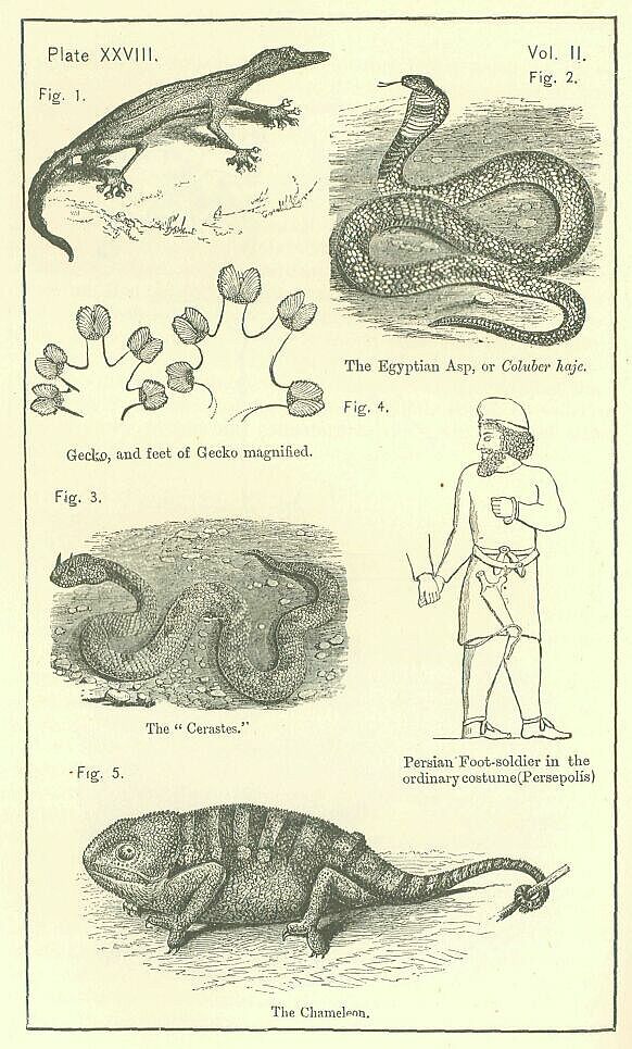
The asp of Egypt (Coluber haje) is a species of cobra. It is a large snake, varying from three to six feet in length, and is extremely venomous. It haunts gardens, where it is of great use, feeding on mice, frogs, and various small reptiles. It has the power of greatly dilating the skin of the neck, and this it does when angered in a way that is very remarkable. Though naturally irritable, it is easily tamed; and the serpent-charmers of the East make it the object of their art more often than any other species. [PLATE XXVIII., Fig. 2.] After extracting the fangs or burning out the poison-bag with a red-hot iron, the charmer trains the animal by the shrill sounds of a small flute, and it is soon perfectly docile.
The cerastes is also employed occasionally by the snake-charmers. It has two long and thin excrescences above the eyes, whereto the name of "horns" has been given: they stand erect, leaning a little backwards; no naturalist has as yet discovered their use. The cerastes is of a very pale brown color, and is spotted with large, unequal, and irregularly-placed spots. Its bite is exceedingly dangerous, since it possesses a virulent poison; and, being in the habit of nearly burying itself in the sand, which is of the same color with itself, it is the more difficult of avoidance. Its size also favors its escaping notice, since in length it rarely much exceeds a foot. [PLATE XXVIII., Fig. 3.]
The chameleon has in all ages attracted the attention of mankind. It is found in Egypt, and in many others parts of Africa, in Georgia, and in India. The power of changing color which it possesses is not really its most remarkable characteristic. Far more worthy of notice are its slow pace, extraordinary form, awkward movements, vivacity, and control of eye, and marvellous rapidity of tongue. It is the most grotesque of reptiles. With protruding and telescopic eyes, that move at will in the most opposite directions, with an ungainly head, a cold, dry, strange-looking skin, and a prehensile tail, the creature slowly steals along a branch or twig, scarcely distinguishable from the substance along which it moves, and scarcely seeming to move at all, until it has come within reach of its prey. Then suddenly, with a motion rapid as that of the most agile bird, the long cylindrical and readily extensile tongue is darted forth with unerring aim, and the prey is seized and swallowed in a single moment of time. The ordinary color of the chameleon is a pale olive-green. This sometimes fades to a sort of ashen-gray, while sometimes it warms to a yellowish-brown, on which are seen faint spots of red. Modern naturalists, for the most part, attribute the changes to the action of the lungs, which is itself affected chiefly by the emotions of anger, desire, and fear. [PLATE XXVIII., Fig. 5.]
The great extent of the Empire caused its vegetable productions to include almost all the forms known to the ancient world. On the one hand, the more northern and more elevated regions bore pines, firs, larches, oaks, birch, beech, ash, ilex, and junipers, together with the shrubs and flowers of the cooler temperate regions; on the other hand, the southern tracts grew palms of various kinds, mangoes, tamarind-trees, lemons, oranges, jujubes, mimosas, and sensitive plants. Between these extremes of tropical and cold-temperate products, the Empire embraced an almost infinite variety of trees, shrubs, and flowers. The walnut and the Oriental plane grew to avast size in many places. Poplars, willows, fig-mulberries, konars, cedars, cypresses, acacias, were common. Bananas, egg-plants, locust-trees, banyans, terebinths, the gum-styrax, the gum-tragacanth, the assafoetida plant, the arbor vitse, the castor-oil plant, the Judas-tree, and other somewhat rare forms, sprang up side by side with the pomegranate, the oleander, the pistachio-nut, the myrtle, the bay, the laurel, the mulberry, the rhododendron, and the arbutus. The Empire grew all the known sorts of grain, and almost all the known fruits. Among its various productions of this class, it is only possible to select for notice a few which were especially remarkable either for their rarity or for their excellent quality.
The ancients celebrated the wheat of AEolis, the dates of Babylon, the citrons of Media, the Persian peach, the grapes of Carmania, the Hyrcanian fig, the plum of Damascus, the cherries of Pontus, the mulberries of Egypt and of Cyprus, the silphium of Gyrene, the wine of Helbon, the wild-grape of Syria. It is not unlikely that to these might have been added as many other vegetable products of first-rate excellence, had the ancients possessed as good a knowledge of the countries included within the Empire as the moderns. At present, the mulberries of Khiva, the apricots of Bokhara, the roses of Mexar, the quinces and melons of Isfahan, the grapes of Kasvin and Shii-az, the pears of Natunz, the dates of Dalaki, have a wide-spread reputation, which appears in most cases to be well deserved. On the whole, it is certain that for variety and excellence the vegetable products of the Persian Empire will bear comparison with those of any other state or community that has as yet existed, either in the ancient or the modern world.
Two only of these products seem to deserve a longer description. The Cyrenaic silphium, of which we hear so much, as constituting the main wealth of that province, was valued chiefly for its medicinal qualities. A decoction from its leaves was used to hasten the worst kind of labors; its root and a juice which flowed from it were employed in a variety of maladies. The plant, which is elaborately described by Theophrastus, appears to have been successfully identified by modern travellers in the Cyrenaica, who see it in the drias or derias of the Arabs, an umbelliferous plant, which grows to a height of about three feet, has a deleterious effect on the camels that browse on it, and bears a striking resemblance to the representations of the ancient silphium upon coins and medals. This plant grows only in the tract between Merj and Derna—the very heart of the old silphium country, while that it has medicinal properties is certain from its effects upon animals; there can thus be little doubt that it is the silphium of the ancients, somewhat degenerated, owing to want of cultivation.
The Egyptian byblus or papyrus (Cyperus papyrus) was perhaps the most valuable of all the vegetables of the Empire. The plant was a tall smooth reed of a triangular shape. It grew to the height of ten or fifteen feet, and terminated in a tuft or plume of leaves and flowers. Though indigenous in the country, it was the subject of careful cultivation, and was grown in irrigated ground, or in such lands as were naturally marshy. The root of the plant was eaten, while from its stem was made the famous Egyptian paper. The manufacture of the papyrus was as follows; The outer rind having been removed, there was exposed a laminated interior, consisting of a number of successive layers of inner cuticle, generally about twenty. These were carefully separated from one another by the point of a needle, and thus were obtained a number of strips of the raw material, which were then arranged in rows, covered with a paste, and crossed at right angles by another set of strips placed over them, after which the whole was converted into paper by means of a strong pressure. A papyrus roll was made by uniting together a greater or less number of such sheets. The best paper was made from the inmost layers of cuticle. The outer rind of the papyrus was converted into ropes; and this fabric was found to be peculiarly adapted for immersion in water.
The mineral treasures of the Empire were various and abundant. It has been noticed already that Persia Proper, if we include in it Carmania, possessed mines of gold, silver, copper, iron, red lead, orpiment, and salt, yielding also bitumen, naphtha, sulphur, and most probably common lead. We are further informed by ancient writers that Drangiana, or Sarangia, furnished the rare and valuable mineral tin, without which copper could not be hardened into bronze; that Armenia yielded emery, so necessary for the working and polishing of gems; that the mountains and mines of the Empire supplied almost all the varieties of useful and precious stones; and that thus there was scarcely a mineral known to and required by the ancients for the purposes of their life which the Great King could not command without having recourse to others than his own subjects. It may be likewise noticed that the more important were very abundant, being found in many places and in large quantities. Gold was furnished from the mountains and deserts of Thibet and India, from the rivers of Lydia, and probably from other places where it is still found, as Armenia, Cabul, and the neighborhood of Meshed. Silver, which was the general medium of exchange in Persia, must have been especially plentiful. It was probably yielded, not only by the Kerman mines, but also by those of Armenia, Asia Minor, and the Elburz. Copper was obtained in great abundance from Cyprus, as well as from Carmania; and it may have been also derived, as it is now in very large quantities, from Armenia. Iron, really the most precious of all metals, existed within the Persian territory in the shape of huge boulders, as well as in nodules and in the form of ironstone. Lead was procurable from Bactria, Armenia, Korman, and many parts of Affghanistan; orpiment from Bactria, Kerman, and the Hazareh country; antimony from Armenia, Affghanistan, and Media; hornblende, quartz, talc, and asbestos, from various places in the Taurus.
Of all necessary minerals probably none was so plentiful and so widely diffused as salt. It was not only in Persia Proper that nature had bestowed this commodity with a lavish hand—there was scarcely a province of the Empire which did not possess it in superfluous abundance. Large tracts were covered by it in North Africa, in Media, in Carmania, and in Lower Babylonia. In Asia Minor, Armenia, Syria, Palestine, and other places, it could be obtained from lakes. In Kerman, and again in Palestine, it showed itself in the shape of large masses, not inappropriately termed "mountains." Finally, in India it was the chief material of a long mountain-range, which is capable of supplying the whole world with salt for many ages.
Bitumen and naptha were also very widely diffused. At the eastern foot of the Caucasus, where it subsides into the Caspian Sea, at various points in the great Mesopotamian plain, in the Deshtistan or low country of Persia Proper, in the Bakh-tiyari mountains, and again in the distant Jordan valley, these two inseparable products are to be found, generally united with indications of volcanic action, present or recent. The bitumen is of excellent quality, and was largely employed by the ancients. The naphtha is of two kinds, black naphtha or petroleum, and white naphtha, which is much preferred to the other. The bitumen-pits also, in some places, yielded salt.
Another useful mineral with which the Persians were very plentifully supplied, was sulphur. Sulphur is found in Persia Proper, in Carmania, on the coast of Mekran, in Azerbijan, in the Elburz, on the Iranian plateau, in the vicinity of the Dead Sea, and in very large quantities near Mosul. Here it is quarried in great blocks, which are conveyed to considerable distances.
Excellent stone for building purposes was obtainable in most parts of the Empire. Egypt furnished an inexhaustible supply of the best possible granite; marbles of various kinds, compact sandstone, limestone, and other useful sorts were widely diffused; and basalt was procurable from some of the outlying ranges of Taurus. In the neighborhood of Nineveh, and in much of the Mesopotamian region, there was abundance of grey alabaster, and a better kind was quarried near Damascus. A gritty silicious rock on the banks of the Euphrates, a little above Hit, was suitable for mill-stones.
The gems furnished by the various provinces of the Empire are too numerous for mention. They included, it must be remembered, all the kinds which have already been enumerated among the mineral products of the earlier Monarchies. Among them, a principal place must, one would think, have been occupied by the turquoise—the gem, par excellence, of modern Persia—although, strange to say, there is no certain mention of it among the literary remains of antiquity. This lovely stone is produced largely by the mines at Nishapur in the Elburz, and is furnished also in less abundance and less beauty by a mine in Kerman, and another near Khojend. It is noticed by an Arabian author as early as the twelfth century of our era. A modern writer on gems supposes that it is mentioned, though not named, by Theophrastus; but this view scarcely seems to be tenable.
Among the gems of most value which the Empire certainly produced were the emerald, the green ruby, the red ruby, the opal, the sapphire, the amethyst, the carbuncle, the jasper, the lapis lazuli, the sard, the agate, and the topaz. Emeralds were found in Egypt, Media, and Cyprus; green rubies in Bactria; common or red rubies in Caria; opals in Egypt, Cyprus, and Asia Minor; sapphires in Cyprus; amethysts also in Cyprus, and moreover in Egypt, Galatia, and Armenia; carbuncles in Caria; jaspers in Cyprus, Asia Minor, and Persia Proper; the lapis lazuli in Cyprus, Egypt, and Media; the sard in Babylonia; the agate in Carmania, Susiana, and Armenia; and the topaz or chrysoprase in Upper Egypt.
The tales which are told of enormous emeralds are undoubtedly fictions, the material which passed for that precious substance being really in these cases either green jasper or (more probably) glass. But lapis lazuli and agate seem to have existed within the Empire in huge masses. Whole cliffs of the former overhang the river Kashkar in Kaferistan; and the myrrhine vases of antiquity which were (it is probable) of agate, and came mainly from Carmania, seem to have been of a great size.
We may conclude this review by noticing, among stones of less consequence produced within the Empire, jet, which was so called from being found at the mouth of the river Gagis in Lycia, garnets, which are common in Armenia, and beryl, which is a product of the same country.
"I lifted up mine eyes, and saw, and, behold, there stood before the river a ram which had two horns: and the two horns were high; but one was higher than the other, and the higher came up last."—Dan. viii. 3.
The ethnic identity of the Persian people with the Medes, and the inclusion of both nations in that remarkable division of the human race which is known to ethnologers as the Ipanic or Arian, have been maintained in a former volume. To the arguments there adduced it seems unnecessary to add anything in this place, since at the present day neither of the two positions appears to be controverted. It is admitted generally, not only that the Persians were of the same stock with the Medes, but that they formed, together with the Medes and a few other tribes and peoples of less celebrity, a special branch of the Indo-European family—a branch to which the name of Arian may be assigned, not merely for convenience sake, but on grounds of actual tradition and history. Undistinguished in the earlier annals of their race, the Medes and Persians became towards the eighth or seventh century before our era, its leading and most important tribes. Closely united together, with the superiority now inclining to one, now to the other, they claimed and exercised a lordship over all the other members of the stock, and not only over them, but over various alien races also. They had qualities which raised them above their fellows, and a civilization, which was not, perhaps, very advanced, but was still not wholly contemptible. Such details as could be collected, either from ancient authors, or from the extant remains, of the character, mode of life, customs, etc., of the Medes, have already found a place in this work.
The greater part of what was there said will apply also to the Persians. The information, however, which we possess, with respect to this latter people, is so much more copious than that which has come down to us with regard to the Medes, that, without repeating anything from the former place, our materials will probably enable us to give to the present chapter considerable dimensions.
The woodcuts of the preceding volume will have made the reader sufficiently familiar with the physiognomy of the Persians, or, at any rate, with the representation of it which has come down to us upon the Persian monuments. It may be remarked that the type of face and head is uniform upon all of them, and offers a remarkable contrast to the type assigned to themselves by the Assyrians, from whom the Arians evidently adopted the general idea of bas-reliefs, as well as their general mode of treating subjects upon them. The novelty of the physiognomy is a strong argument in favor of its truthfulness; and this is further confirmed by the evidence which we have, that the Persian artists aimed at representing the varieties of the human race, and succeeded fairly in rendering them. Varieties of, physiognomy are represented upon the bas-reliefs with much care, and sometimes with remarkable success, as the annexed head of a negro, taken from one of the royal tombs, will sufficiently indicate. [PLATE XXIX., Fig.1.]
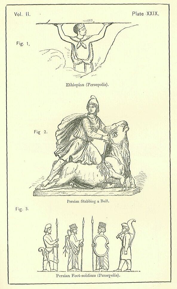
According to Herodotus, the skulls of the Persians were extraordinarily thin and weak—a phenomenon for which he accounted by the national habit of always covering the head. There does not seem to be in reality any ground for supposing that such a practice would at all tend to produce such a result. If, therefore, we regard the fact of thinness as established, we can only view it as an original feature in the physical type of the race. Such a feature would imply, on the supposition that the heads were of the ordinary size, a large brain-cavity, and so an unusual volume of brain, which is generally a concomitant of high intellectual power.
The Persians seem, certainly, to have been quick and lively, keen-witted, capable of repartee, ingenious, and, for Orientals, far-sighted. They had fancy and imagination, a relish for poetry and art, and they were not without a certain power of political combination. But we cannot justly ascribe to them any high degree of intellectual excellence. The religious ideas which they held in common with the Medes were, indeed, of a more elevated character than is usual with races not enlightened by special revelation; but these ideas were the common stock of the Iranic peoples, and were inherited by the Persians from a remote ancestry, not excogitated by themselves. Their taste for art, though marked, was neither pure nor high. We shall have to consider, in a future chapter, the architecture and mimetic art of the people to weigh their merits in these respects, and, at the same time, to note their deficiencies.
Without anticipating the exact verdict then to be pronounced, we may say at once that there is nothing in the remains of the Persian architecture and sculpture that have come down to us indicative of any remarkable artistic genius; nothing that even places them on a par with the best works of the kind produced by Orientals. Again, if the great work of Firdausi represents to us, as it probably does, the true spirit of the ancient poetry of the Persians, we must conclude that, in the highest department of art, their efforts were but of moderate merit. A tone of exaggeration, an imagination exuberant and unrestrained, a preference for glitter over solid excellence, a love of far-fetched conceits, characterize the Shahnameh; and, though we may fairly ascribe something of this to the idiosyncrasy of the poet, still, after we have made all due allowance upon this score, the conviction presses upon us that there was a childish and grotesque character in the great mass of the old Persian poetry, which marks it as the creation of moderate rather than of high intellectual power, and prevents us from regarding it with the respect with which we view the labors of the Greeks and Romans, or, again, of the Hebrews, in this department. A want of seriousness, a want of reality, and, again, a want of depth, characterize the poetry of Iran, whose bards do not touch the chords which rouse what is noblest and highest in our nature. They give us sparkle, prettiness, quaint and ingenious fancies, grotesque marvels, an inflated kind of human heroism; but they have none of the higher excellencies of the poetic art, none of the divine fire which renders the true poet, and the true prophet, one.
Among moral qualities, we must assign to the Persians as their most marked characteristics, at any rate in the earlier times, courage, energy, and a regard for truth. The valor of their troops in the great combats of Platsea and Thermopylae extorted the admiration of their enemies, who have left on record their belief that, "in boldness and warlike spirit, the Persians were not a whit behind the Greeks," and that their defeat was "wholly owing to the inferiority of their equipment and training." Without proper shields, with little defensive armor, wielding only short swords and lances that were scarcely more than javelins, they dashed themselves upon the serried ranks of the Spartans, seizing the huge spear-shafts of these latter with their hands, striving to break them, and to force a way in. No conduct could have been braver than this, which the modern historian well compares with brilliant actions of the Romans and the Swiss. The Persians thoroughly deserved to be termed (as they are termed by AEschylus), a "valiant-minded people;" they had boldness, elan, dash, and considerable tenacity and stubbornness; no nation of Asia or Africa was able to stand against them; if they found their masters in the Greeks, it was owing, as the Greeks themselves tell us, to the superiority of Hellenic arms, equipment, and, above all, of Hellenic discipline, which together rendered the most desperate valor unavailing, when it lacked the support of scientific organization and united simultaneous movement.
The energy of the Persians during the earlier years of their ascendancy is no less remarkable than their courage. AEschylus speaks of a mysterious fate which forced them to engage continually in a long series of wars, to take delight in combats of horse, and in the siege and overthrow of cities. Herodotus, in a tone that is not very different, makes Xerxes, soon after his accession, represent himself as bound by the examples of his forefathers to engage his country in some great enterprise, and not suffer the military spirit of his people to decay through want of employment. We shall find, when we come to consider the history of the Empire, that, for eighty years, under four sovereigns, the course indicated by these two writers was in fact pursued—that war followed on war, expedition on expedition—the active energy of sovereign and people carrying them on, without rest or pause, in a career of conquest that has few parallels in the history of Oriental nations. In the subsequent period, this spirit is less marked; but, at all times, a certain vigor and activity has characterized the race, distinguishing it in a very marked way from the dreamy and listless Hindus upon the one hand, and the apathetic Turks upon the other.
The Persian love of truth was a favorite theme with the Greeks, who were, perhaps, the warmer in their praises from a latent consciousness of their own deficiency in the virtue. According to Herodotus, the attention of educators was specially directed to the point, and each young Persian was taught by his preceptors three main things:—"To ride, to draw the bow, and to speak the truth." We find that, in the Zendavesta, and more especially in its earliest and purest portions, truth is strenuously inculcated. Ahura-Mazda himself is "true," "the father of all truth," and his worshippers are bound to conform themselves to his image. Darius, in his inscriptions, protests frequently against "lies," which he seems to regard as the embodiment of all evil. A love of finesse and intrigue is congenital to Orientals; and, in the later period of their sway, the Persians appear to have yielded to this natural inclination, and to have used freely in their struggle with the Greeks the weapons of cunning and deception; but, in the earlier period, a different spirit prevailed; lying was then regarded as the most disgraceful act of which a man could possibly be guilty truth was both admired and practised; Persian kings, entrapped into a promise, stood to it firmly, however much they might wish it recalled; foreign powers had never to complain that the terms of a treaty were departed from; the Persians thus form an honorable exception to the ordinary Asiatic character, and for general truthfulness and a faithful performance of their engagements compare favorably with the Greeks and Romans.
The Persian, if we may trust Herodotus, was careful to avoid debt. He had a keen sense of the difficulty with which a debtor escapes subterfuge and equivocation—forms, slightly disguised, of lying. To buy and sell wares in a market place, to chaffer and haggle over prices, was distasteful to him, as apt to involve falsity and unfairness. He was free and open in speech, bold in act, generous, warm-hearted, hospitable. His chief faults were an addiction to self-indulgence and luxury, a passionate abandon to the feeling of the hour, whatever that might happen to be; and a tameness and subservience in all his relations towards his prince, which seem to moderns almost incompatible with real self-respect and manliness.
The luxury of the Persians will be considered when we treat of their manners. In illustration of the two other weak points of their character, it may be observed that, in joy and in sorrow, they were alike immoderate; in the one transported beyond all reasonable bounds, and exhibiting their transports with entire unreserve and openness; in the other proportionately depressed, and quite unrestrained in the expression of their anxiety or misery. AEschylus' tragedy of the "Persae" is, in this respect, true to nature, and represents with accuracy the real habits of the nation. The Persian was a stranger to the dignified reserve which has commonly been affected by the more civilized among Western nations. He laughed and wept, shouted and shrieked, with the unrestraint of a child, who is not ashamed to lay bare his inmost feelings to the eyes of those about him. Lively and excitable, he loved to give vent to every passion that stirred his heart, and cared not how many witnessed his lamentations or his rejoicings.
The feeling of the Persian towards his king is one of which moderns can with difficulty form a conception. In Persia the monarch was so much the State, that patriotism itself was, as it were, swallowed up in loyalty; and an absolute unquestioning submission, not only to the deliberate will, but to the merest caprice of the sovereign, was, by habit and education, so engrained into the nature of the people that a contrary spirit scarcely ever manifested itself. In war the safety of the sovereign was the first thought, and the principal care of all. The tales told of the self-devotion of individuals to secure the preservation of the monarch may not be true, but they indicate faithfully the actual tone of men's sentiments about the value of the royal person. If the king suffered, all was lost; if the king escaped, the greatest calamities seemed light, and could be endured with patience. Uncomplaining acquiescence in all the decisions of the monarch—cheerful submission to his will, whatever it might chance to be—characterized the conduct of the Persians in time of peace. It was here that their loyalty degenerated into parasitical tameness, and became a defect instead of a virtue. The voice of remonstrance, of rebuke, of warning, was unheard at the Court; and tyranny was allowed to indulge unchecked in the wildest caprices and extravagances. The father, whose innocent son was shot before his eyes by the king in pure wantonness, instead of raising an indignant protest against the crime, felicitated him on the excellence of his archery. Unfortunates, bastinadoed by the royal orders, declared themselves delighted, because his majesty had condescended to recollect them. A tone of sycophancy and servility was thus engendered, which, sapping self-respect, tended fatally to lower and corrupt the entire character of the people.
In considering the manners and customs of the Persians, it will be convenient to follow the order already observed in treating of Assyria and Media—that is to say, to treat, in the first instance, of their warlike, and subsequently of their peaceful usages. On the latter the monuments throw considerable light; on the former, the information which they supply is comparatively scanty.
The Persians, like the Medes, regarded chariots with disfavor, and composed their armies almost entirely of foot and horse. The ordinary dress of the foot-man was, in the earlier times, a tunic with long sleeves, made of leather, and fitting rather tightly to the frame, which it covered from the neck to the knee. Under this was worn a pair of trousers, also of leather, and tolerably tight-fitting, especially at the ankles, where they met a sort of high shoe, or low boot. The head was protected by a loose round cap, apparently of felt, which projected a little in front, and rose considerably above the top of the head. Round the waist was worn a double girdle or belt, from which depended a short sword. [PLATE XXVIII Fig. 4.]
The offensive arms of the foot-man were, a sword, a spear, and a bow. The sword, which was called by the Persians akinaces, appears to have been a short, straight weapon, suited for stabbing rather than for cutting, and, in fact, not very much better than a dagger. [PLATE XXIX., Fig. 2.] It was carried in a sheath, and was worn suspended from the girdle on the right side. From the Persepolitan sculptures it would seem not to have hung freely, but to have been attached to the right thigh by a thong which passed round the knee. The handle was short, and generally unprotected by a guard; but, in some specimens, we see a simple cross-bar between the hilt and the blade.
The spear carried by the Persian foot-man was also short, or, at any rate, much shorter than the Greek. To judge by the representations of guardsmen on the Persepolitan sculptures, it was from six to six and a half or seven feet in length. The Grecian spear was sometimes as much as twenty-one feet. The Persian weapon had a short head, which appears to have been flattish, and which was strengthened by a bar or ridge down the middle. The shaft, which was of cornel wood, tapered gradually from bottom to top, and was ornamented at its lower extremity with a ball, sometimes carved in the shape of an apple or a pomegranate. [PLATE XXIX., Fig. 3.]
The Persian bow, according to Herodotus and Xenophon, was of unusual size. According to the sculptures, it was rather short, certainly not exceeding four feet. It seems to have been carried strung, either on the left shoulder, with the arm passed through it, or in a bow-case slung at the left side. It was considerably bent in the middle, and had the ends slightly turned back. [PLATE XXX., Fig. 1.] The arrows, which were of reed, tipped with metal, and feathered, were carried in a quiver, which hung at the back near the left shoulder. To judge from the sculptures, their length must have been about two feet and a half. The arrow-heads, which were either of bronze or iron, seem to have been of various shapes, the most common closely resembling the arrow-heads of the Assyrians. [PLATE XXX., Fig. 3.]
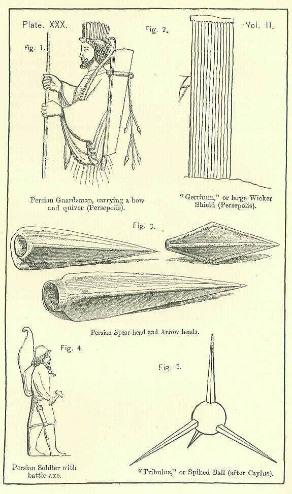
Other offensive weapons carried occasionally by the Persian foot-men were, a battle-axe, a sling, and a knife. The battle-axe, which appears in the sculptures only in one or two instances, is declared to have been a common Persian weapon by Xenophon, who, upon such a point, would seem to be trustworthy. The use of the sling by the Persian light-armed is quite certain. It is mentioned by Curtius and Strabo, no less than by Xenophon; and the last-named writer speaks with full knowledge on the subject, for he witnessed the effect of the weapon in the hands of Persian slingers during his return with the Ten Thousand. The only missiles which the Persian slingers threw were stones; they did not, like the Rhodians, make use of small lumps of lead.
The knife seems also to have been a Persian weapon. Its blade appears to have been slightly curved, like that of a pruning-hook. It was worn in a sheath, and was probably thrust into the belt or girdle like the similar weapon, half knife, half dagger, of a modern Persian.
The ordinary defence of the Persian against the weapons of his enemy was a shield of wicker-work, which covered him almost from head to foot, and which probably differed little from the wattled shield of the Assyrians. [PLATE XXX., Fig. 2.] This he commonly planted on the ground, supporting it, perhaps, with a crutch, while he shot his arrows from behind it. Occasionally, he added to this defence the protection of a coat of mail, composed either of scale armor, or of quilted linen, like the corselets of the Egyptians. Armor of the former kind was almost impenetrable, since the scales were of metal—iron, bronze, or sometimes gold—and overlapped one another like those of a fish.
The Persian cavalry was armed, in the early times of the monarchy, almost exactly in the same manner as their infantry. Afterwards, however a considerable change seems to have been made. In the time of the younger Cyrus cavalry soldiers were very fully protected. They wore helmets on their heads, coats of mail about their bodies, and greaves on their legs. Their chief offensive arms seem, then, to have been the short sword, the javelin, and the knife. It is probable that they were without shields, being sufficiently defended by their armor, which (as we have seen) was almost complete.
The javelin of the horseman, which was his special weapon, was a short strong spear or pike, with a shaft of cornel-wood, and an iron point. It was common for him to carry two such weapons, one of which he used as a missile, while he retained the other in order to employ it in hand-to-hand combat with the enemy. It was a stout manageable weapon, and though no match for the longer and equally strong spear of the Macedonian cavalry, was preferred by Xenophon to the long weak reed-lance commonly carried by horse-soldiers in his day.
It was the practice of the later Persians to protect with armor, not only the horseman, but the horse. They selected for the service large and powerful animals, chiefly of the Nisaean breed, and cased them almost wholly in mail. The head was guarded by a frontlet, and the neck and chest by a breast-piece; the sides and flanks had their own special covering and cuisses defended the thighs. These defences were not merely, like those of the later Assyrian heavy cavalry, of felt or leather, but consisted, like the cuirasses worn by the riders, of some such material covered with metal scales. The weight which the horse had to sustain was thus very great, and the movements of the cavalry force were, in consequence, slow and hesitating. Flight was difficult; and, in a retreat, the weaker animals were apt to sink under their burdens, and to be trampled to death by the stronger ones.
There can be no doubt that, besides these heavy horsemen, the Persians employed, even in the latest times, and much more in the earlier, a light and agile cavalry force. Such were the troops which, under Tissaphernes, harassed the Ten Thousand during their retreat; and such, it may be conjectured, was really at all times the great body of their cavalry. The education of the Persian, as we shall see hereafter, was directed to the formation of those habits of quickness and agility in the mounting and managing of horses, which have a military value only as furnishing a good training for the light-cavalry service; and the tendency of the race has at all times been, not to those forms of military organization which are efficient by means of solidity and strength, but to those lighter, more varied, and more elastic branches which compensate for a want of solidity by increased activity, readiness, and ease of movement.
Though the Persians did not set any great store by chariots, as an arm of the military service, they nevertheless made occasional use of them. Not only were their kings and princes, when they commanded their troops in person, accustomed to direct their movements, both on the march and even inaction, from the elevation of a war-chariot, but now and then, in great battles, a considerable force of them was brought into the field, and important consequences were expected from their employment. The wheels of the war-chariots were armed with scythes; and these, when the chariot was set in motion, were regarded as calculated to inflict great damage on the ranks of opponents. Such hopes seem, however, to have been generally disappointed. As every chariot was drawn by at least two horses, and contained at least two persons—the charioteer and the warrior—a large mark was offered by each to the missiles of the light troops who were commonly stationed to receive them; and, as practically it was found that a single wound to either horse or man threw the whole equipage into confusion, the charge of a scythed chariot was commonly checked before it reached the line of battle of the enemy. Where this was not the case, the danger was escaped by opening the ranks and letting the chariots pass through them to the rear, a good account being speedily given of any adventurer who thus isolated himself from the support of his own party.
The Persian war-chariot was, probably, somewhat loftier than the Assyrian. The wheels appear to have been from, three to four feet in diameter; and the body rose above them to a height from the ground of nearly five feet. The person of the warrior was thus protected up to his middle by the curved board which enclosed the chariot on three sides. The axle-tree is said to have been broad, since breadth afforded a security against being overturned, and the whole construction to have been strong and solid. The wheels had twelve spokes, which radiated from a nave of unusual size. The felloes were narrower than the Assyrian, but were still composed, like them, of two or three distinct layers of wood. The tires were probably of metal, and were indented like the edge of a saw. [PLATE XXXI., Fig. 1.]
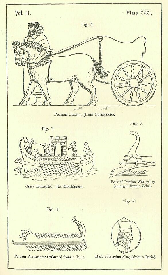
No great ornamentation of the chariot appears to have been attempted. The body was occasionally patterned with a chequer-work, which maybe compared with a style common in Assyria, and the spokes of the wheels were sometimes of great elegance, but the general character of the workmanship was massive and plain. The pole was short, and terminated with a simple curve. From the evidence of the monuments it would seem that chariots were drawn by two horses only; but the classical writers assure us that the ordinary practice was to have teams of four. The harness used was exceedingly simple, consisting of a yoke, a belly-band, a narrow collar, a head-stall, a bit, and reins. When the charioteer left his seat, the reins could be attached to a loop or bar which projected from the front of the chariot-board.
Chariots were constructed to contain two, or perhaps, in some instances, three persons. These consisted of the warrior, his charioteer, who stood beside him, and an attendant, whose place was behind, and whose business it was to open and shut the chariot doors. The charioteer wore a visor and a coat of mail, exposing nothing to the enemy but his eyes.
The later Persians made use also of elephants in battle, but to a very small extent, and without any results worth mentioning.
The chief points of Persian tactics were the following. The army was organized into three distinct services—those of the chariots, the horse, and the foot. In drawing up the line of battle, it was usual, where chariots were employed, to place them in the front rank, in front of the rest of the army. Behind the chariots were stationed the horse and the foot; the former generally massed upon the wings; the latter placed in the middle, drawn up according to nations, in a number of oblong squares, which touched, or nearly touched, one another. The bravest and best armed troops were placed in front; the ranks towards the rear being occupied by those of inferior quality. The depth of the ranks was usually very great, since Oriental troops cannot be trusted to maintain a firm front unless they are strongly supported from behind. No attempt, however, seems to have been made at forming a second line of battle in the rear of the first, nor does there even seem to have been any organized system of reserves. When the battle began, the chariots were first launched against the enemy, whose ranks it was hoped they would confuse, or, at any rate, disturb. After this the main line advanced to the attack, but without any inclination to come at once to close quarters. Planting their shields firmly on the ground in front of them, the Persian heavy-armed shot flight after flight of arrows against their foe, while the slingers and other light-armed in the rear sent clouds of missiles over the heads of their friends into the adverse ranks beyond them. It was usually the enemy which brought this phase of the battle to an end, by pressing onward and closing with the Persian main line in a hand:to-hand combat. Here the struggle was commonly brief—a very few minutes often decided the engagement. If the Persian line of battle was forced or broken, all was immediately regarded as lost—flight and rout followed. The cavalry, from its position on the wings, might attempt, by desperate charges on the flanks of the advancing foe, to stay his progress, and restore the fortune of the day, but such efforts were usually unavailing. Its line of battle once broken, a Persian army lost heart; its commander commonly set the example of flight, and there was a general rush of all arms from the battle-field.
For success the Persians trusted mainly to their numbers, which enabled them, in some cases, to renew an attack time after time with fresh troops, in others to outflank and surround their adversary. Their best troops were undoubtedly their cavalry, both heavy and light. The heavy, armed in the old times with bows, and in the later with the javelins, highly distinguished itself on many important occasions. The weight of its charge must have been great; its offensive weapons were good; and its armor made it almost invulnerable to ordinary weapons. The light cavalry was celebrated for the quickness and dexterity of its manoeuvres. It had the loose organization of modern Bashi-Bazouks or Cossacks; it hung in clouds on the enemy—assailed, retreated, rallied, re-advanced—fled, and even in flight was formidable, since each rider was trained to discharge his arrows backwards with a sure aim. against the pursuing foe. The famous skill of the Parthians in their horse-combats was inherited from their Persian predecessors, who seem to have invented the practice which the later people carried to perfection.
Though mainly depending for success on their numbers, the Persians did not wholly despise the use of contrivance and stratagem. At Arbela, Darius Codomannus had spiked balls strewn over the ground where he expected the Greek cavalry to make its attacks. [PLATE XXX., Fig. 5]; and, at Sardis, Cyrus obtained his victory over the Lydian horse by frightening them with the grotesque and unfamiliar camel. Other instances will readily occur to the reader, whereby it appears that the art of war was studied, and ingenuity allowed its due place in military matters, by this people, who showed a fair share of Oriental subtlety in the devices which they employed against their enemies.
It is doubtful whether we are to include among these devices the use of military engines. On the one hand, we have several distinct statements by the author of the "Cyrpoasdia," to the effect that engines were well known to the Persians; on the other, we remark an entire absence from the works of other ancient writers of any notice that they actually employed them, either in their battles or their sieges. The silence of Scripture, of Herodotus, of the inscriptions, of Quintus Curtius, of Arrian, may fairly be regarded as outweighing the unsupported authority of the romance-writer, Xenophon; and though it would be rash to decide that such things as siege-towers, battering rams, and balistce—all of which are found to have been in constant use under the Assyrian and Babylonian monarchies—were wholly discarded by, or unknown to, their successors in the government of Asia, yet a wise criticism will conclude, that they were, at any rate, unfamiliar to the Persians, rarely and sparingly (if at all) employed by them, other methods of accomplishing the ends whereto they served having more approved themselves to this ingenious people. In ordinary sieges it would seem that they trusted to the bank or mound, while sometimes they drove mines under the walls, and sought in this way to effect a breach. Where the place attacked was of great strength, they had recourse in general either to stratagem or to blockade. Occasionally they employed the destructive force of fire, and no doubt they often succeeded by the common method of escalade. On the whole, it must certainly be said that they were successful in their sieges, exhibiting in their conduct of them courage, activity, and considerable fertility of resource.
A Persian army was usually, though not always, placed under a single commander. This commander was the monarch, if he was present; if not, it was a Persian, or a Mede, nominated by him. Under the commander-in-chief were a number of general officers, heads of corps or divisions, of whom we find, in one instance, as many as nine. Next in rank to these were the chiefs of the various ethnic contingents composing the army, who were, probably, in general the satraps of the different provinces. Thus far appointments were held directly from the crown; but beyond this the system was changed. The ethnic or satrapial commanders appointed the officers next below themselves, the captains over a thousand, and (if their contingent was large enough to admit it) the captains over ten thousand; who, again, nominated their subordinates, commanders of a hundred, and commanders of ten. Thus, in the main, a decimal scale prevailed. The lowest rank of officers commanded each ten men, the next lowest a hundred, the next to that a thousand, the next ten thousand. The officer over ten thousand was sometimes a divisional chief; sometimes he was subject to the commander of an ethnic contingent, who was himself under the orders of the head of a division. Altogether there were six ranks of officers, exclusive of the commander-in-chief.
The proper position of the commander-in-chief was considered to be the centre of the line of battle. He was regarded as safer there than he would have been on either wing; and it was seen that, from such a position, his orders would be most rapidly conveyed to all parts of the battlefield. It was not, however, thought to be honorable that he should keep aloof from the fight, or avoid risking his own person. On the contrary, he was expected to take an active part in the combat; and therefore, though his place was not exactly in the very foremost ranks, it was towards the front, and the result followed that he was often exposed to imminent danger. The consequences of this arrangement were frequently disastrous in the extreme, the death or flight of the commander producing universal panic, stopping the further issue of any general order, and thus paralyzing the whole army.
The numbers of a Persian army, though no doubt exaggerated by the Greeks, must have been very great, amounting, probably, on occasions, to more than a million of combatants. Troops were drawn from the entire empire, and were marshalled in the field according to nations, each tribe accoutred in its own fashion. Here were seen the gilded breastplates and scarlet kilts of the Persians and Medes; there the woollen shirt of the Arab, the leathern jerkin of the Berber, or the cotton dress of the native of Hindustan. Swart savage Ethiops from the Upper Nile, adorned with a war-paint of white and red, and scantily clad with the skins of leopards or lions, fought in one place with huge clubs, arrows tipped with stone, and spears terminating in the horn of an antelope. In another, Scyths, with their loose spangled trousers and their tall pointed caps, dealt death around from their unerring blows; while near them Assyrians, helmeted, and wearing corselets of quilted linen, wielded the tough spear, or the still more formidable iron mace. Rude weapons, like cane bows, unfeathered arrows, and stakes hardened at one end in the fire, were seen side by side with keen swords and daggers of the best steel, the finished productions of the workshops of Phoenicia and Greece. Here the bronze helmet was surmounted with the ears and horns of an ox; there it was superseded by a fox-skin, a leathern or wooden skull-cap, or a head-dress fashioned out of a horse's scalp. Besides horses and mules, elephants, camels, and wild asses, diversified the scene, and rendered it still more strange and wonderful to the eye of a European. One large body of cavalry was accustomed to enter the field apparently unarmed; besides the dagger, which the Oriental never lays aside, they had nothing but a long leathern thong. They used this, however, just as the lasso is used by the natives of Brazil, and the wretch at whom they aimed their deadly noose had small chance of escape. The Persians, like the Assyrians, usually avoided fighting during the winter, and marched out their armies against the enemy in early spring. With the great hosts which they moved a fixed order of march was most necessary; and we find evidence of so much attention being paid to this point that confusion and disorder seem scarcely ever to have arisen. When the march lay within their own country, it was usual to send on the baggage and the sumpter-beasts in advance, after which came about half the troops, moving slowly in a long and continuous column along the appointed line of route. At this point a considerable break occurred, in order that all might be clear for the most important part of the army, which was now to follow. A guard, consisting of a thousand horse and a thousand foot, picked men of the Persian people, prepared the way for what was most holy in the eyes of the nation—the emblems of their religion, and their king. The former consisted of sacred horses and cars; perhaps, in the later times, of silver altars also, bearing the perpetual and heaven-kindled fire, which was a special object of Persian religious regard, and which the superstition of the people viewed as a sort of palladium, sure to bring the blessings of heaven upon their arms. Behind the sacred emblems followed the Great King himself, mounted on a car drawn by Nissean steeds, and perhaps protected on either side by a select band of his relatives. Behind the royal chariot came a second guard, consisting, like the first, of a thousand foot and a thousand horse. Then followed ten thousand picked foot, probably the famous "Immortals;" then came a body of ten thousand picked Persian horsemen. After these a space of four hundred yards (nearly a quarter of a mile) was left vacant; then marched, in a second continuous column, the remainder of the host.
On entering an enemy's country, or drawing near a hostile force in their own, certain alterations in these dispositions became necessary, and were speedily effected. The baggage-train was withdrawn, and instead of moving before the army, followed at some little distance in the rear. Horsemen were thrown out in front, to feel for the enemy and notify his arrival. Sometimes, if the host was large, a division of the troops was made, and several corps d'armee advanced against the foe simultaneously by distinct routes. When this took place, the commander-in-chief was careful to accompany the central force, so as to find himself in his proper position if he was suddenly compelled to give battle.
Night movements were seldom attempted by the Persians. They marched from sunrise to sunset, halting, probably, during the midday heat. In their most rapid marches they seldom accomplished more than from twenty to twenty-five miles in the day; and when this rate was attempted for any continuance, it was necessary to rest the men at intervals for as much as three days at a time. The great drag upon rapidity of movement was the baggage-train, which consisted ordinarily of a vast multitude of camels, horses, asses, mules, oxen, etc., in part carrying burthens upon their backs, in part harnessed to carts laden with provisions, tents, and other necessaries. The train also frequently comprised a number of litters, in which the wives or female companions of the chief men were luxuriously conveyed, amid a crowd of eunuchs and attendants, and with all the cumbrous paraphernalia of female wardrobes. Roads, it must be remembered, did not exist; rivers were not bridged, except occasionally by boats; the army marched on the natural ground along an established line of route which no art had prepared for the passage of man or beast. Portions of the route would often be soft and muddy; the carts and litters would become immovable, their wheels sinking into the mire up to the axles; all the efforts of the teams would be unavailing; it must have been imperative to halt the main line, and employ the soldiers in the release of the vehicles, which had to be lifted and carried forward till the ground was sufficiently firm to bear them. When a river crossed the line of route, a ford had to be sought, boats procured, or rafts extemporized. The Persians were skilful in the passage of streams, to which they became accustomed in their first campaigns under Cyrus; but the march was necessarily retarded by these and similar obstacles, and we cannot be surprised that the average rate of movement was slow.
As evening approached the Persians sought a suitable place for their camp. An open plain was preferred for the purpose, and the vicinity of water was a necessity. If an enemy was thought to be at hand, a ditch was rapidly dug, and the earth thrown up inside; or if the soil was sandy, sacks were filled with it, and the camp was protected with sand-bags. Immediately within the rampart were placed the gerrhophori, or Persians armed with large wicker shields. The rest of the soldiers had severally their appointed places, the position assigned to the commander-in-chief being the centre. All the army had tents, which were pitched so as to face the east. The horses of the cavalry were tethered and hobbled in front of the tents of their owners.
The Persians disliked encamping near to their enemy. They preferred an interval of seven or eight miles, which they regarded as a considerable security against a surprise. As their most important arm was the cavalry, and as it was impossible for the cavalry to unfasten and unhobble their steeds, to equip them properly, to arm themselves, and then to mount in a short space of time, when darkness and confusion reigned around, a night attack on the part of an enterprising enemy would have been most perilous to a Persian army. Hence the precaution which they observed against its occurrence—a precaution which was seldom or never omitted where they felt any respect for their foe, and which seems to have been effective, since we do not hear of their suffering any disaster of the kind which they so greatly feared.
The Persians do not seem to have possessed any special corps of pioneers. When the nature of the country was such as to require the felling of timber or the removal of brushwood, the army was halted, and the work was assigned to a certain number of the regular soldiers. For the construction of bridges, however, in important places, and for other works on a grand scale intended to facilitate an expedition, preparations were made beforehand, the tasks being entrusted either to skilled workmen, or to the crews of ships, if they were tolerably easy of performance.
Commissariat arrangements were generally made by the Persians on a large scale, and with the best possible results. An ample baggage-train conveyed corn sufficient to supply the host during some months and in cases where scarcity was apprehended, further precautions were taken. Ships laden with corn accompanied the expedition as closely as possible, and supplemented any deficiency that might arise from a failure on the part of the land transport department. Sometimes, too, magazines were established at convenient points along the intended line of march previously to the setting forth of the army, and stores were thus accumulated at places where it was probable they would be found of most service.
Requisitions for supplies were also made upon the inhabitants of the towns and villages through which lay the route of the army. Whenever the host rested for a night at a place of any consequence, the inhabitants seem to have been required to furnish sufficient bread for a meal to each man, and, in addition, to provide a banquet for the king (or general) and his suite, which was always very numerous. Such requisitions, often intolerably burthensome to those upon whom they were laid, must have tended greatly to relieve the strain upon their own resources, which the sustentation of such enormous hosts as the Persian kings were in the habit of moving, cannot have failed to produce in many cases.
The effectiveness of these various arrangements for the provisioning of troops upon a march was such that Persian armies were rarely, if ever, in any difficulty with respect to their subsistence. Once only in the entire course of their history do we hear of the Persian forces suffering to any considerable extent from a want of supplies. According to Herodotus, Cambyses, when he invaded Ethiopia, neglected the ordinary precautions and brought his army into such straits that his men began to eat each other. This caused the total failure of his expedition, and the loss of a great proportion of the troops employed in it. There is, however, reason to suspect that, even in this case, the loss and difficulty which occurred have been much exaggerated.
The Persians readily gave quarter to the enemy who asked it, and generally treated their prisoners of war with much kindness. Personages of importance, as monarchs or princes, either preserved their titles and their liberty, with even a certain nominal authority, or received appanages in other parts of the Persian territory, or, finally, were retained about the Court as friends and table-companions of the Great King. Those of less rank were commonly given lands and houses in some province remote from their own country, and thenceforth held the same position as the great mass of the subject races. Exchanges of prisoners do not seem to have been thought of. In a few cases, persons, whom we should regard as prisoners of war, experienced some severities, but probably only when they were viewed by the Persians, not as fair enemies, but as rebels. Rebels were, of course, liable to any punishment which the king might think it right to inflict upon them, and there were occasions after a revolt when sentences of extreme rigor were passed upon the persons considered to have been most in fault. According to Herodotus, three thousand Babylonians were crucified by order of Darius, to punish their revolt from him; and, though this is probably an exaggeration, it is certain that sometimes, where an example was thought to be required, the Persians put to death, not only the leader of a rebellion, but a number of his chief adherents. Crucifixion, or, at any rate, impalement of some sort, was in such cases the ordinary punishment. Sometimes, before a rebel was executed, he was kept for a while chained at the king's door, in order that there might be no doubt of his capture.
Among the minor punishments of rebellion were branding, and removal of the rebels en masse from their own country, to some remote locality. In this latter case, they were merely treated in the same way as ordinary prisoners of war. In the former, they probably became royal slaves attached to the household of the monarch.
Though the Persians were not themselves a nautical people, they were quite aware of the great importance of a navy, and spared no pains to provide themselves with an efficient one. The conquests of Phoenicia, Cyprus, Egypt, and the Greek islands were undertaken, it is probable, mainly with this object; and these parts of the Empire were always valued chiefly as possessing skilled seamen, vessels, and dockyards, from which the Great King could draw an almost inexhaustible supply of war-ships and transports. Persia at times had the complete command of the Mediterranean Sea, and bore undisputed sway in the Levant during almost the whole period of her existence as an empire.
The war-ship preferred by the best naval powers during the whole period of the Persian rule was the trireme, or decked galley impelled by rowers sitting in three tiers, or banks, one above another. This vessel, the invention of the Corinthians, had been generally adopted by the nations bordering on the Mediterranean in the interval between B.C. 700 and B.C. 525, when by the reduction of Phoenicia, Cyprus, and Egypt, the Persians obtained the command of the sea. Notwithstanding the invention of quadriremes by the Carthaginians before B.C. 400, and of quinqueremes by Dionysius the Elder soon after, the trireme stood its ground, and from first to last the Persian fleets were mainly composed of this class of vessels.
The trireme was a vessel of a considerable size, and was capable of accommodating two hundred and thirty persons. Of these, two hundred constituted the crew, while the remaining thirty were men-at-arms, corresponding to our own "marines." By far the greater number of the crew consisted of the rowers, who probably formed at least nine-tenths of the whole, or one hundred and eighty out of the two hundred. The rowers sat, not on benches running right across the vessel, but on small seats attached to its side. They were arranged, as before stated, in three tiers, not, however, directly one over the head of another, but obliquely, each at once above and behind his fellow. Each rower had the sole management of a single oar, which he worked through a hole pierced in the side of the vessel. To prevent his oar from slipping he had a leathern strap, which he twisted round it, and fastened to the thole, probably by means of a button. The remainder of the crew comprised the captain, the steersman, the petty officers, and the sailors proper, or those whose office it was to trim the sails and look to the rigging. The trireme of Persian times had, in all cases, a mast, and at least one sail, which was of a square shape, hung across the mast by means of a yard or spar, like the "square-sail" of a modern vessel. The rudder was composed of two broad-bladed oars, one on either side of the stern, united, however, by a cross-bar, and managed by a single steersman. The central part of a trireme was always decked, and on this deck, which was generally level with the bulwarks, stood and fought the men-at-arms, whose business it was to engage the similar force of the enemy.
The weapon of the trireme, with which she was intended chiefly to attack her foe, was the beak. [PLATE XXXI., Fig. 3.] This consisted of a projection from the prow of the ship, either above or below the water-line, strongly shod with a casting of iron, and terminating either in the head of an animal, or in one or more sharp points. A trireme was expected, like a modern "ram," to use this implement against the sides of her adversary's vessels, so as to crush them in and cause the vessels to sink. Driven by the full force of her oars, which impelled her almost at the rate of a modern steamer, she was nearly certain, if she struck her adversary full, to send ship and men to the bottom. She might also, it is true, greatly damage herself; but, to preclude this, it was customary to make the whole prow of a trirene exceedingly strong, and, more particularly, to support it with beams at the side which tended to prevent the timbers from starting.
Besides triremes, which constituted the bulk of the Persian navy, there were contained in their fleet various other classes of vessels, as triaconters, penteconters, cercuri, and others. Triaconters were long, sharp-keeled ships, shaped very much like a trireme, rowed by thirty rowers, who sat all upon a level, like the rowers in modern boats, fifteen on either side of the vessel. [PLATE XXXI., Fig. 2.] Penteconters were very similar, the only difference being in the number of the oars and oarsmen. [PLATE XXXI., Fig. 4.] Both these classes of vessels seem to have been frequently without sails. Cercuri were light boats, very long and swift. They are said to have been invented by the Cyprians, and were always peculiar to Asia.
The transports of the Persians were either for the conveyance of horses or of food. Horse-transports were large clumsy vessels, constructed expressly for the service whereon they were used, possessing probably a special apparatus for the embarkation and disembarkation of the animals which they were built to carry. Corn-transports seem to have been of a somewhat lighter character. Probably, they varied very considerably in their size and burthen, including huge and heavy merchantmen on the one hand, and a much lighter and smaller craft on the other.
The Persians used their ships of war, not only for naval engagements, but also for the conveyance of troops and the construction of bridges. Accustomed to pass the great streams which intersect Western Asia by bridges of boats, which were permanently established wherever an unfordable river crossed any of the regular routes connecting the provinces with the capital, the Persians, when they proceeded to carry their arms from Asia into Europe, conceived the idea of bridging the interval between the continents, which did not much exceed the width of one of the Mesopotamian streams, by constructions similar in principle and general character to those wherewith long use had made them familiar in their own country. Ranging a number of vessels side by side, at no great distance one from another, parallel with the course of the stream, which ran down the straits, anchoring each vessel stem and stern to keep it in place, and then laying upon these supports a long wooden platform, they made a floating bridge of considerable strength, reaching from the Asiatic to the European coast, on which not only men, but horses, camels, chariots, and laden carts passed over safely from the one continent to the other. Only, as the water which they had to cross was not a river, but an arm of the real salt sea, and might, therefore, in case of a storm, show a might and fury far beyond a river's power, they thought it necessary to employ, in lieu of boats, the strongest ships which they possessed, namely, triremes and pentecon-ters, as best capable of withstanding the force of an angry sea. Bridges of this kind were intended sometimes for temporary, sometimes for permanent constructions. In the latter case, great care and much engineering skill was lavished on their erection. The shore cables, which united the ships together, and sustained the actual bridge or platform, were made of most carefully selected materials, and must have been of enormous strength; the ships were placed in close proximity one to another; and by the substitution of a double for a single line—of two bridges, in fact, for one—the solidity of the work was very largely augmented. Yet, rare as was the skill shown, solid and compact as were the causeways thus thrown by human art over the sea, they were found inadequate to the end desired. The great work of Xerxes, far the most elaborate of its class, failed to withstand the fury of the elements for a single year; the bridge, constructed in one autumn, was utterly swept away in the next; and the army which had crossed into Europe by its aid had to embark as it best could, and return on board ship to Asia.
As the furnishing of the Persian fleet was left wholly to the subject nations of the Empire, so was its manning intrusted to them almost entirely. Phoenicians, Syrians, Egyptians, Cypriots, Cilicians, Lycians, Pamphylians, Carians, Greeks, equipped in the several costumes of their countries, served side by side in their respective contingents of ships, thereby giving the fleet nearly the same motley appearance which was presented by the army. In one respect alone did the navy exhibit superior uniformity to their sister service—the epibatae, or "marines," who formed the whole fighting force of the fleet while it kept the sea, was a nearly homogeneous body, consisting of three races only (two of which were closely allied), namely, Persians, Medes, and Sacse. Every ship had thirty such men on board; all, it is probable, uniformly armed, and all animated by one and the same spirit. To this force the Persians must have owed it mainly that their great fleets were not mere congeries of mutually repellant atoms, but were capable of acting against an enemy with a fair amount of combination and singleness of purpose.
When a fleet accompanied a land army upon an expedition, it was usually placed under the same commander. This commander, however, was not expected to adventure himself on board much less to take the direction of a sea-fight. He intrusted the fleet to an officer, or officers, whom he nominated, and was content himself with the conduct of operations ashore. Occasionally the land and sea forces were assigned to distinct commanders of co-ordinate authority—an arrangement which led naturally, to misunderstanding and quarrel.
The tactics of a Persian fleet seem to have been of the simplest kind Confident in their numbers, until experience had taught them the fallaciousness of such a ground of hope, they were chiefly anxious that their enemy should not escape. To prevent this they endeavored to surround the ships opposed to them, advancing their line in a crescent form, so as to enclose their adversary's wings, or even detaching squadrons to cut off his retreat. They formed their line several ships deep and when the hour of battle came, advanced directly at their best speed against the enemy, endeavoring to run down his vessels by sheer force, and never showing any acquaintance with or predilection for manoeuvres of a skilful antagonist, who avoided or successfully withstood this first onset, they were apt through their very numbers to be thrown into disorder: the first line would become entangled with the second, the second with the third, and inextricable confusion would be the result. Confusion placed them at the mercy of their antagonist, who, retaining complete command over his own vessels, was able to strike theirs in vulnerable parts, and, in a short time, to cover the sea with shattered and sinking wrecks. The loss to the Persians in men as well as in material, was then sure to be very great; for their sailors seldom knew how to swim, and were consequently drowned, even when the shore was but a few yards distant.
When, from deficiency in their numbers, or distrust of their own nautical skill in comparison with that of their enemy, the commanders of a Persian fleet wished to avoid an engagement, a plan sometimes adopted was to run the ships ashore upon a smooth soft beach, and, after drawing them together, to surround them with such a rampart as could be hastily made, and defend this rampart with the sailors. The crews of the Persian vessels were always more or less completely armed, in order that, if occasion arose, they might act as soldiers ashore, and were thus quite capable of fighting effectively behind a rampart. They might count, too, under such circumstances, upon assistance from such of their own land forces as might happen to be in the neighborhood, who would be sure to come with all speed to their aid, and might be expected to prove a sure protection.
The subject nations who furnished the Persians with their fleet were, in the earlier times, the Phoenicians, the Egyptians, the Cypriots, the Cilicians, the Syrians of Palestine, the Pamphylians, the Lycians, the Carians, and the Greeks of Asia Minor and the islands. The Greeks seem to have furnished the largest number of ships; the Phoenicians, the next largest; then the Egyptians; after them the Cypriots; then the Cilicians; then the Carians; next the Lycians; while the Pamphylians furnished the least. The best ships and the best sailors were the Phoenicians, especially those of Sidon. In later times, ships were drawn either from Phoenicia alone, or from Phoenicia, Cilicia, and Cyprus.
The limits assigned to the present work forbid the further prosecution of this branch of our inquiry, and require us now to pass on from the consideration of the Persian usages in war, to that of their manners and customs, their habits and proceedings, in time of peace. And here it will once more be convenient to follow a division of the subject with which the reader is familiar, and to treat first of the public life of the King and Court, and next of the private life of the people.
The Persian king held the same rank and position in the eyes of his subjects which the great monarch of Western Asia, whoever he might be, had always occupied from time immemorial. He was their lord and master, absolute disposer of their lives, liberties, and property; the sole fountain of law and right, incapable himself of doing wrong, irresponsible irresistable—a sort of God upon earth; one whose favor was happiness, at whose frown men trembled, before whom all bowed themselves down with the lowest and humblest obeisance.
To a personage so exhalted, a state and pomp of the utmost magnificence was befitting. The king's ordinary dress in time of peace was the long flowing "Median garment," or candys—made in his case (it is probable) of richest silk, which, with its ample folds, its wide hanging sleeves, and its close fit about the neck and chest, gave dignity to almost any figure, and excellently set off the noble presence of an Achaemenian prince. The royal robe was either of purple throughout, or sometimes of purple embroidered with gold. It descended below the ankles; resting on the foot even when the monarch was seated. A broad girdle confined it at the waist. Under it was worn a tunic, or shirt, which reached from the neck to the knee, and had tight-fitting sleeves that covered the arm to the wrist. The tunic was purple in color, like the candys, or robe, but striped or mixed with white. The lower limbs were encased in trousers of a crimson hue. On his feet the the king wore shoes like those of the Medes, long and taper at the toe buttoned in front, and reaching very high up the instep: their color was deep yellow or saffron. [PLATE XXXII., Fig.1.]
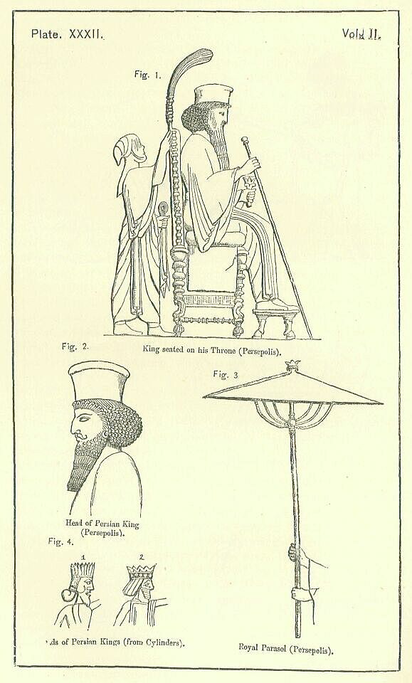
Thus far the monarch's costume, though richer in material than the dress of the Persian nobles, and in some points different in color, was on the whole remarkably like that of the upper class of his subjects. It was, however, most important that his dress should possess some distinguishing feature, and that that feature should be one of very marked prominency. In an absolute monarchy the king must be unmistakable, at almost any distance, and almost in any light. Consequences of the gravest kind may follow from any mistake of the royal identity; and it is therefore essential to the comfort both of prince and subject that some very conspicuous badge shall mark and notify the monarch's presence. Accordingly, it appears that the Persian ruler was to be known by his headdress, which was peculiar alike in shape and in color, and was calculated to catch the eye in both respects. It bore the name kitaris or hidaris, and was a tall stiff cap, slightly swelling as it ascended, flat at top, and terminating in a ring or circle which projected beyond the lines of the sides. Round it, probably near the bottom, was worn a fillet or band—the diadem proper—which was blue, spotted with white.
As the other Persians wore either simple fillets round their heads, or soft, rounded, and comparatively low caps, with no band round them, the king's headdress, which would tower above theirs and attract attention by its color, could readily be distinguished even in the most crowded Court.
It has been asserted that the kidaris, or tiara of the Persian kings, was "commonly adorned with gold and jewelry;" and this may possibly have been the case, but there is no evidence that it was so. Its material was probably either cloth or felt, and it was always of a bright color, though not (apparently) always of the same color. Its distinguishing features were its height, its stiffness, and the blue and white fillet which encircled it.
Among other certain indications of the royal presence may be mentioned the golden sceptre, and the parasol. The sceptre, which is seen frequently in the king's hands, was a plain rod, about five feet in length, ornamented with a ball, or apple, at its upper end, and at its lower tapering nearly to a point. The king held it in his right hand, grasping it near, but not at, the thick end, and rested the thin end on the ground in his front. When he walked, he planted it upright before him, as a spearman would plant his spear. When he sate, he sloped it outwards, still, however, touching the ground with its point.
The parasol, which has always been in the East a mark of dignity, seems in Persia, as in Assyria, to have been confined, either by law or usage, to the king. The Persian implement resembled the later Assyrian, except that it was not tasselled, and had no curtain or flap. It had the same tent-like shape, the same long thick stem, and the same ornament at the top. It only differed in being somewhat shallower, and in having the supports, which kept it open, curved instead of straight. It was held over the king's head on state occasions by an attendant who walked immediately behind him. [PLATE XXXII., Fig. 3.]
The throne of the monarch was an elevated seat, with a high back, but without arms, cushioned, and ornamented with a fringe, and with moldings or carvings along the back and legs. The ornamentation consisted chiefly of balls and broad rings, and contained little that was artistic or elaborate. The legs, however, terminated in lions' feet, resting upon half balls, which were ribbed or fluted. The sides of the chair below the seat appear to have been panelled, like the thrones of the Assyrians, but were not adorned with any carving. The seat of the throne was very high from the ground, and without a rest the legs would have dangled. A footstool consequently was provided, which was plain, like the throne, but was supported on legs terminating in the feet of bulls. Thus the lion and the bull, so frequent in the symbolism of the East, were here again brought together, being represented as the supports of the throne.
With respect to the material whereof the throne was composed, there can be no doubt that it was something splendid and costly. Late writers describe it as made of pure gold; but, as we hear of its having silver feet, we may presume that parts at least were of the less precious metal. Ivory is not said to have been used in its composition. We may, perhaps, conjecture, that the frame of the throne was wood, and that this was overlaid with plates of gold or silver, whereby the whole of the woodwork was concealed from view, and an appearance of solid metal presented.
The person of the king was adorned with golden ornaments. He had earrings of gold in his ears, often inlaid with jewels he wore golden bracelets upon his wrists; and he had a chain or collar of gold about his neck. [PLATE XXXIII., Fig. 1.] In his girdle, which was also of gold, he carried a short sword, the sheath of which was formed of a single precious stone. The monuments, unfortunately, throw little light on the character and workmanship of these portions of the royal costume. We may gather from them, perhaps, that the bracelets had a large jewel set in their centre, and that the collars were of twisted work, worn loosely around the neck. The sword seems to have differed little from that of the ordinary Persians. It had a short straight blade, a mere crossbar for a guard, and a handle almost devoid of ornament. This plainness was compensated, if we may trust Curtius, by the magnificence of the sheath, which was, perhaps, of jasper, agate, or lapis lazuli. [PLATE XXXIII., Fig. 2.]
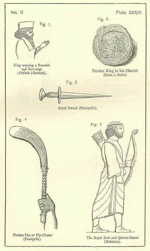
The officers in most close attendance on the monarch's person were, in war, his charioteer, his stool-bearer, his bow-bearer, and his quiver-bearer; in peace, his parasol-bearer, and his fan bearer, who was also privileged to carry what has been termed "the royal pocket-handkerchief."
The royal charioteer is seemingly unarmed. His head is protected merely by a fillet. He sits in front of his master, and both his hands are fully occupied with the management of the reins. He has no whip, and seems to urge his horses forward simply by leaning forward himself, and slackening or shaking the reins over them. He was, no doubt, in every case a Persian of the highest rank, such near proximity to the Royal person being a privilege to which none but the very noblest could aspire. [PLATE XXXIII., Fig. 2.]
The office of the stool-bearer, was to assist the king as he mounted his chariot or dismounted from it. He carried a golden stool, and followed the royal chariot closely, in order that he might be at hand whenever his master felt disposed to alight. On a march, the king was wont to vary the manner of his travelling, exchanging, when the inclination took him, his chariot for a litter, and riding in that more luxurious vehicle till he was tired of it, after which he returned to his chariot for a space. The services of the stool-bearer were thus in constant requisition, since it was deemed quite impossible that his Majesty could ascend or descend his somewhat lofty war-car without such aid.
The rank of the bow-bearer was probably nearly as great as that of the driver of the chariot. He was privileged to stand immediately behind the monarch on grand occasions, so carrying in his left hand the weapon from which he derived his appellation. The quiver-bearer had the next place. Both wore the Median costume—the candys, or flowing robe, the girdle, the high shoe, and the stiff fluted cap, or, perhaps, occasionally the simple fillet. Sometimes the two offices would seem to have been held by the same person, unless we are to attribute this appearance, where it occurs, to the economy of the artist, who may have wished to save himself the trouble of drawing two separate figures. [PLATE XXXIII., Fig. 5.]
The parasol-bearer was attired as the bow and quiver bearers, except that he was wholly unarmed, and had the fillet for his proper head-dress. Though not a military officer, he accompanied the monarch in his expeditions, since in the midst of war there might be occasions of state when his presence would be convenient. The officer who bore the royal fan and handkerchief had generally the same costume; but sometimes his head was enveloped in a curious kind of cowl or muffler, which covered the whole of it except the forehead, the eyes, the nose, the mouth, and the upper portion of the cheeks. [PLATE XXXIV., Fig. 1.]
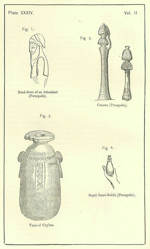
The fan, or fly-chaser, had a long straight handle, ornamented with a sort of beading, which held a brush of some springy fibrous matter. [PLATE XXXIII., Fig. 4.] The bearer, whose place was directly behind the monarch, held his implement, which bent forward gracefully, nearly at arm's length over his master's head.
It would seem that occasionally the bearer of the handkerchief laid aside his fly-chaser, and assumed in lieu of it a small bottle containing perfumery. [PLATE XXXIV., Fig. 4.] In a sculptured tablet at Persepolis, given by Ker Porter, an attendant in the Median robe, with a fillet upon his head, who bears the handkerchief in the usual way in his left hand, carries in the palm of his right what seems to be a bottle, not-unlike the scent-bottle of a modern lady. It has always been an Oriental custom to wash the hands before meals, and the rich commonly mix some perfumery or other with the water. We may presume that this was the practice at the Persian Court, and that the Great King therefore took care to have an officer, who should at all times be ready to provide his guests, or himself, with the scent which was most rare or most fashionable.
The Persians seem to have been connoisseurs in scents. We are told that, when the royal tiara was not in wear, it was laid up carefully with a mixture of myrrh and labyzus, to give it an agreeable odor. Unguents were thought to have been a Persian invention, and at any rate were most abundantly used by the upper classes of the nation. The monarch applied to his own person an ointment composed of the fat of lions, palm wine, saffron, and the herb helianthes, which was considered to increase the beauty of the complexion. He carried with him, even when he went to the wars, a case of choice unguents; and such a treasure fell into the hands of Alexander, with the rest of Darius's camp equipage, at Arbela. It may be suspected that the "royal ointment" of the Parthian kings, composed of cinnamon, spikenard, myrrh, cassia, gum styrax, saffron, cardamum, wine, honey, and sixteen other ingredients, was adopted from the Persians, who were far more likely than the rude Parthians to have invented so recondite a mixture. Nor were scents used only in this form by the ingenious people of whom we are speaking. Arabia was required to furnish annually to the Persian crown a thousand talents' weight of frankincense; and there is reason to believe that this rare spice was largely employed about the Court, since the walls of Persepolis have several representations of censers, which are sometimes carried in the hands of an attendant, while sometimes they stand on the ground immediately in front of the Great King. [PLATE XXXIV., Fig. 2.]
The box or vase in which the Persians commonly kept their unguents was of alabaster. This stone, which abounded in the country, was regarded as peculiarly suited for holding ointments, not only by the Persians, but also by the Egyptians, the Greeks, and (probably) the Assyrians. The Egyptian variety of stone seems to have been especially valued; and vases appear to have been manufactured in that country for the use of the Persian monarch, which were transmitted to the Court, and became part of the toilet furniture of the palace.330 [PLATE XXXIV., Fig. 3.]
Among the officers of the Court, less closely attached to the person of the monarch than those above enumerated, may be mentioned the steward of the household; the groom or master of the horse; the chief eunuch, or keeper of the women; the king's "eyes" and "ears," persons whose business it was to keep him informed on all matters of importance; his scribes or secretaries, who wrote his letters and his edicts; his messengers, who went his errands; his ushers, who introduced strangers to him; his "tasters," who tried the various dishes set before him lest they should be poisoned; his cupbearers who handed him his wine, and tasted it; his chamberlains, who assisted him to bed; and his musicians, who amused him with song and harp. Besides these, the Court comprised various classes of guards, and also doorkeepers, huntsmen, grooms, cooks, and other domestic servants in great abundance, together with a vast multitude of visitors and guests, princes, nobles, captives of rank, foreign refugees, ambassadors, travellers. We are assured that the king fed daily within the precincts of his palace as many as fifteen thousand persons, and that the cost of each day's food was four hundred talents. A thousand beasts were slaughtered for each repast, besides abundance of feathered game and poultry. The beasts included not only sheep, goats, and oxen, but also stags, asses, horses, and camels. Among the feathered delicacies were poultry, geese, and ostriches.
The monarch himself rarely dined with his guests. For the most part he was served alone. Sometimes he admitted to his table the queen and two or three of his children. Sometimes, at a "banquet of wine," a certain number of privileged boon companions were received, who drank in the royal presence, not, however, of the same wine, nor on the same terms.
The monarch reclined on a couch with golden feet, and sipped the rich wine of Helbon; the guests drank an inferior beverage, seated upon the floor. At a great banquet, it was usual to divide the guests into two classes. Those of lower degree were entertained in an outer court or chamber to which the public had access, while such as were of higher rank entered the private apartments, and drew near to the king. Here they were feasted in a chamber opposite to the king's chamber, which had a curtain drawn across the door, concealing him from their gaze, but not so thick as to hide them from their entertainer. Occasionally, on some very special occasion, as, perhaps, on the Royal birthday, or other great festival, the king presided openly at the banquet, drinking and discoursing with his lords, and allowing the light of his countenance to shine freely upon a large number of guests, whom, on these occasions, he treated as if they were of the same flesh and blood with himself. Couches of gold and silver were spread for all, and "royal wine in abundance" was served to them in golden goblets. On these, and, indeed, on all occasions, the guests, if they liked, carried away any portion of the food set before them which they did not consume at the time, conveying it to their homes, where it served to support their families.
The architecture of the royal palace will be discussed in another chapter; but a few words may be said in this place with respect to its furniture and general appearance. The pillared courts and halls of the vast edifices which the Achaemenian monarchs raised at Susa and Persepolis would have had a somewhat bare and cold aspect, if it had not been for their internal fittings. The floors were paved with stones of various hues, blue, white, black, and red, arranged doubtless into patterns, and besides were covered in places with carpeting. The spaces between the pillars were filled with magnificent hangings, white green, and violet, which were fastened with cords of fine linen (?) and purple to silver rings and pillars of marble, screening the guests from sight, while they did not too much exclude the balmy summer breeze. The walls of the apartments were covered with plates of gold. All the furniture was rich and costly. The golden throne of the monarch stood under an embroidered canopy or awning supported by four pillars of gold inlaid with precious stones. [PLATE XXXV.] Couches resplendent with silver and gold filled the rooms. The private chamber of the monarch was adorned with a number of objects, not only rich and splendid, but valuable as productions of high art. Here, impending over the royal bed, was the golden vine, the work of Theodore of Samos, where the grapes were imitated by means of precious stones, each of enormous value. Here, probably, was the golden plane-tree, a worthy companion to the vine, though an uncourtly Greek declared it was too small to shade a grasshopper. Here, finally, was a bowl of solid gold, another work of the great Samian metallurgist, more precious for its artistic workmanship than even for its material.
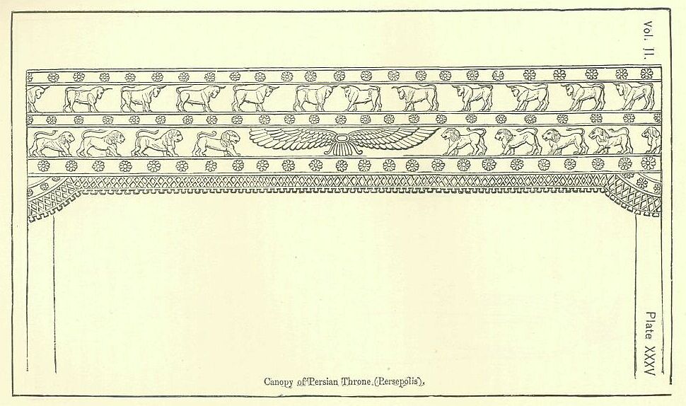
Nothing has hitherto been said of the Royal harem or seraglio, which, however, as a feature of the Court always important, and ultimately preponderating over all others, claims a share of our attention. In the early times, it would appear that the Persian kings were content with three or four wives, and a moderate number of concubines. Of the wives there was always one who held the most exalted place, to whom alone appertained the title of "Queen," and who was regarded as "wife" in a different sense from the others. Such was Atossa to Darius Hystaspis, Amestris to Xerxes, Statira to Darius Codomannus. Such, too, were Vashti and Esther to the prince, whoever he was, whose deeds are recorded in Scripture under the name of Ahasuerus. The chief wife, or Queen-Consort, was privileged to wear on her head a royal tiara or crown. She was the acknowledged head of the female apartments or Gynaeceum, and the concubines recognized her dignity by actual prostration. On great occasions, when the king entertained the male part of the Court, she feasted all the females in her own part of the palace. She had a large revenue of her own, assigned her, not so much by the will of her husband, as by an established law or custom. Her dress was splendid, and she was able to indulge freely that love of ornament of which few Oriental women are devoid. Though legally subject to her husband as much as the meanest of his slaves, she could venture on liberties which would have been fatal to almost any one else, and often, by her influence over the monarch, possessed a very considerable share of power.
The status of the other wives was very inferior to this; and it is difficult to see how such persons were really in a position much superior to that of the concubines. As daughters of the chief nobles—for the king could only choose a wife within a narrow circle—they had, of course, a rank and dignity independent of that acquired by marriage; but otherwise they must have been almost on a par with those fair inmates of the Gynaeceum who had no claim even to the name of consort. Each wife had probably a suite of apartments to herself, and a certain number of attendants—eunuchs, and tirewomen—at her disposal; but the inferior wives saw little of the king, being only summoned each in their turn to share his apartment, and had none of the privileges which made the position of chief wife so important.
The concubines seem to have occupied a distinct part of the Gynaeceum, called "the second house of the women." They were in the special charge of one of the eunuchs, and were no doubt kept under strict surveillance. The Empire was continually searched for beautiful damsels to fill the harem, a constant succession being required, as none shared the royal couch more than once, unless she attracted the monarch's regard very particularly. In the later times of the Empire, the number of the concubines became enormous, amounting (according to one authority) to three hundred and twenty-nine, (according to another) to three hundred and sixty. They accompanied the king both in his wars and in his hunting expeditions. It was a part of their duty to sing and play for the royal delectation; and this task, according to one author, they had to perform during the whole of each night. It is a more probable statement that they entertained the king and queen with music while they dined, one of them leading, and the others singing and playing in concert.
The Gynaeceum—in the Susa palace, at any rate—was a building distinct from the general edifice, separated from the "king's house" by a court. It was itself composed of at least three sets of apartments—viz. apartments for the virgins who had not yet gone into the king, apartments for the concubines, and apartments for the Queen-Consort and the other wives. These different portions were under the supervision of different persons. Two eunuchs of distinction had the charge respectively of the "first" and of the "second house of the women." The Queen-Consort was, at any rate nominally, paramount in the third, her authority extending over all its inmates, male and female.
Sometimes there was in the Gynaeceum a personage even more exalted than any which have as yet been mentioned. The mother of the reigning prince, if she outlived his father, held a position at the Court of her son beyond that even of his Chief Wife. She kept the ensigns of royalty which she had worn during the reign of her husband; and wielded, as Queen-Mother, a far weightier and more domineering authority than she ever exercised as Queen-Consort. The habits of reverence and obedience, in which the boy had been reared, retained commonly their power over the man; and the monarch who in public ruled despotically over millions of men, succumbed, within the walls of the seraglio, to the yoke of a woman, whose influence he was too weak to throw off. The Queen-Mother had her seat at the royal table whenever the king dined with his wife; and, while the wife sat below, she sat above the monarch. She had a suite of eunuchs distinct from those of her son. Ample revenues were secured to her, and were completely at her disposal. She practically exercised—though she could not perhaps legally claim—a power of life and death. She screened offenders from punishment, procuring for them the royal pardon, or sheltering them in her own apartments; and she poisoned, or openly executed, those who provoked her jealousy or resentment.
The service of the harem, so far as it could not be fitly performed by women, was committed to eunuchs. Each legitimate wife—as well as the Queen-Mother—had a number of these unfortunates among her attendants; and the king intrusted the house of the concubines, and also that of the virgins, to the same class of persons. His own attendants seem likewise to have been chiefly eunuchs. In the later times, the eunuchs acquired a vast political authority, and appear to have then filled all the chief offices of state. They were the king's advisers in the palace, and his generals in the field. They superintended the education of the young princes, and found it easy to make them their tools. The plots and conspiracies, the executions and assassinations, which disfigure the later portion of the Persian annals, maybe traced chiefly to their intrigues and ambition. But the early Persian annals are free from these horrors; and it is clear that the power of the eunuchs was, during this period, kept within narrow bounds. We hear little of them in authentic history till the reign of Xerxes. It is remarkable that the Persepolitan sculptures, abounding as they do in representations of Court life, of the officers and attendants who approached at all closely to the person of the monarch, contain not a single figure of a eunuch in their entire range. We may gather from this that there was at any rate a marked difference between the Assyrian and the early Persian Court in the position which eunuchs occupied at them respectively: we should not, however, be justified in going further and questioning altogether the employment of eunuchs by the Persian monarchs during the early period, since their absence from the sculptures may be accounted for on other grounds.
It is peculiarly noticeable in the Persian sculptures and inscriptions that they carry to excess that reserve which Orientals have always maintained with regard to women. The inscriptions are wholly devoid of all reference to the softer sex, and the sculptures give us no representation of a female. In Persia, at the present day, it is regarded as a gross indecorum to ask a man after his wife; and anciently it would seem that the whole sex fell under a law of taboo, which required that, whatever the real power and influence of women, all public mention of them, as well as all representations of the female form, should be avoided. If this were so, it must of course still more have been the rule that the women—or, at any rate, those of the upper classes—should not be publicly seen. Hence the indignant refusal of Vashti to obey the command of King Aha-suerus to show herself to his Court. Hence, too, the law which made it a capital offence to address or touch one of the royal concubines or even to pass their litters upon the road. The litters of women were always curtained; and when the Queen Statira rode in hers with the curtains drawn, it was a novelty which attracted general attention, as a relaxation of the ordinary etiquette, though only females were allowed to come near her. Married women might not even see their nearest male relatives, as their fathers and brothers; the unmarried had, it is probable, a little more liberty.
As the employment of eunuchs at the Persian Court was mainly in the harem, and in offices connected therewith, it is no wonder that they shared, to some extent, in the law of taboo, which forbade the representation of women. Their proper place was in the female courts and apartments, or in close attendance upon the litters, when members of the seraglio travelled, or took the air—not in the throne-room, or the antechambers, or the outer courts of the palace, which alone furnished the scenes regarded as suitable for representation.
Of right, the position at the Persian Court immediately below that of the king belonged to the members of certain privileged families. Besides the royal family itself—or clan of the Achaemenidae—there were six great houses which had a rank superior to that of all the other grandees. According to Herodotus these houses derived their special dignity from the accident that their heads had been fellow-conspirators with Darius Hystaspis; but there is reason to suspect that the rank of the families was precedent to the conspiracy in question, certain families conspiring because they were great, and not becoming great because they conspired. At any rate, from the time of Darius I., there seem to have been seven great families, including that of the Achaemenidae, whose chiefs had the privilege of free communication with the monarch, and from which he was legally bound to choose his legitimate wives. The chiefs appear to have been known as "the Seven Princes," or "the Seven Counsellors," of the king. They sat next to him at public festivals; they were privileged to tender him their advice, whenever they pleased; they recommended important measures of state, and were, in part, responsible for them; they could demand admission to the monarch's presence at any time, unless he were in the female apartments; they had precedence on all great occasions of ceremony, and enjoyed a rank altogether independent of office. Sometimes—perhaps most commonly—they held office; but they rather conferred a lustre on the position which they consented to fill, than derived any additional splendor from it.
It does not appear that the chiefs of the seven great families had any peculiar insignia. Officers of the Court, on the contrary, seem to have always carried, as badges marking their position, either wands about three feet in length, or an ornament resembling a lotos blossom, which is sometimes seen in the hands of the monarch himself. Such officers wore, at their pleasure, either the long Median robe and the fluted cap, or the close-fitting Persian tunic and trousers, with the loose felt [Greek name]. All had girdles, in which sometimes a dagger was placed; and all had collars of gold about their necks, and earrings of gold in their ears. The Median robes were of various colors—scarlet, purple, crimson, dark gray, etc. Over the Persian tunic a sleeved cloak, or great coat, reaching to the ankles, was sometimes worn; this garment was fastened by strings in front, and descended loosely from the shoulders, no use being commonly made of the sleeves, which hung empty at the wearer's side. [PLATE XXXVI., Fig. 1.]
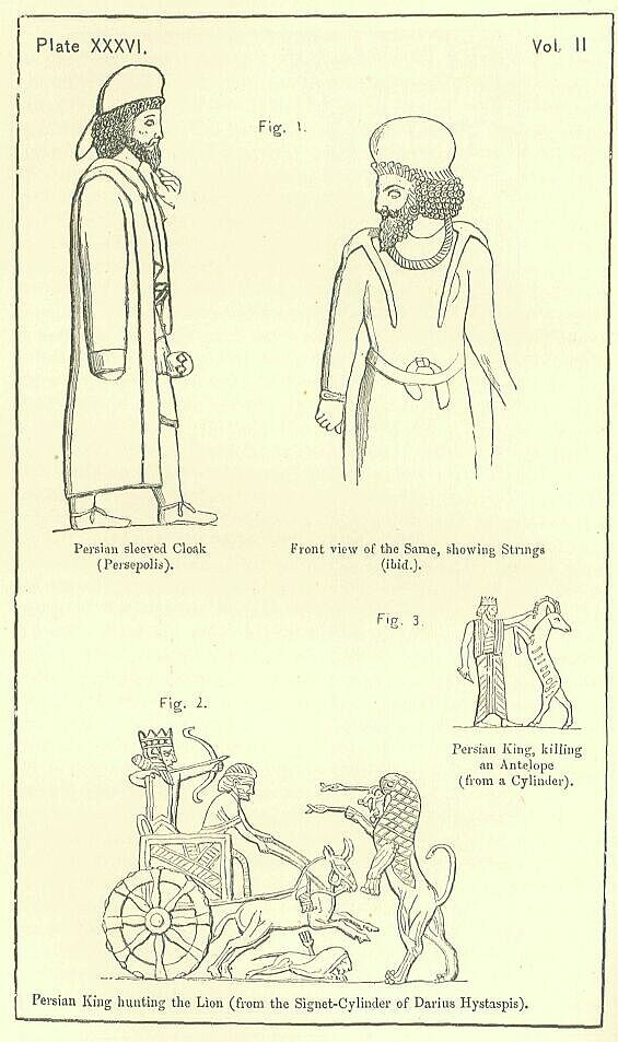
An elaborate Court ceremonial was the natural accompaniment of the ideas with respect to royalty embodied in the Persian system. Excepting the "Seven Princes," no one could approach the royal person unless introduced by a Court usher, Prostration—the attitude of worship—was required of all as they entered the presence. The hands of the persons introduced had to be hidden in their sleeves so long as their audience lasted. In crossing the Palace Courts it was necessary to abstain carefully from touching the carpet which was laid for the king to walk on. Coming into the king's presence unsummoned was a capital crime, punished by the attendants with instant death, unless the monarch himself, as a sign that he pardoned the intrusion, held out towards the culprit the golden sceptre which he bore in his hands. It was also a capital offence to sit down, even unknowingly, upon the royal throne; and it was a grave misdemeanor to wear one of the king's cast-off dresses. Etiquette was almost as severe on the monarch himself as on his subjects. He was required to live chiefly in seclusion; to eat his meals, for the most part, alone; never to go on foot beyond the palace walls; never to revoke an order once given, however much he might regret it; never to draw back from a promise, whatever ill results he might anticipate from its performance. To maintain the quasi-divine character which attached to him it was necessary that he should seem infallible, immutable, and wholly free from the weakness of repentance.
As some compensation for the restrictions laid upon him, the Persian king had the sole enjoyment of certain luxuries. The wheat of Assos was sent to the Court to furnish him with bread, and the vines of Helbon were cultivated for the special purpose of supplying him with wine. Water was conveyed to Susa for his use from distant streams regarded as specially sweet and pure; and in his expeditions he was accompanied, by a train of wagons, which were laden with silver flasks, filled from the clear stream of the Choaspes. The oasis of Ammon contributed the salt with which he seasoned his food. All the delicacies that the Empire anywhere produced were accumulated on his board, for the supply of which each province was proud to send its best and choicest products.
The chief amusements in which the Great King indulged were hunting and playing at dice. Darius Hystaspis, who followed the chase with such ardor as on one occasion to dislocate his ankle in the pursuit of a wild beast, had himself represented on his signet-cylinder as engaged in a lion-hunt. From this representation, we learn that the Persian monarchs, like the Assyrian, pursued the king of beasts in their chariots, and generally despatched him by means of arrows. Seated in a light car, and attended by a single unarmed charioteer, they invaded the haunts of these fiercest of brutes, rousing them from their lairs—probably with Indian hounds, and chasing them at full speed if they fled, or, if they faced the danger, attacking them with arrows or with the javelin. [PLATE XXXVI., Fig. 2.] Occasionally the monarch might indulge in this sport alone; but generally he was (it seems) accompanied by some of his courtiers, who shared the pleasures of the chase with him on the condition that they never ventured to let fly their weapons before he had discharged his. If they disregarded this rule they were liable to capital punishment, and might esteem themselves fortunate if they escaped with exile.
Besides lions, the Persian monarch chased, it is probable, stages, antelopes, wild asses, wild boars, bears, wild sheep, and leopards. [PLATE XXXVI., Fig. 3.] These animals all abounded in the neighborhood of the royal palaces, and they are enumerated by Xenophon among the beasts hunted by Cyrus. The mode of chasing the wild ass was for the horsemen to scatter themselves over the plain, and to pursue the animal in turns, one taking up the chase when the horse of another was exhausted. The speed of the creature is so great that no horse with a rider on his back can long keep pace with him; and thus relays were necessary to tire him out, and enable the hunters to bring him within the range of their weapons.
When game was scarce in the open country, or when the kings were too indolent to seek it in its native haunts, they indulged their inclination for sport by chasing the animals which they kept in their own "paradises." These were walled enclosures of a large size, well wooded, and watered with sparkling streams, in which were bred or kept wild beasts of various kinds, chiefly of the more harmless sorts, as stags, antelopes, and wild sheep. These the kings pursued and shot with arrows, or brought down with the javelin; but the sport was regarded as tame, and not to be compared with hunting in the open field.
Within the palace the Persian monarchs are said to have amused themselves with dice. They played, it is probable, chiefly with their near relatives, as their wives, or the Queen-Mother. The stakes, as was to be expected, ran high, as much as a thousand darics (nearly L 1100.) being sometimes set on a single throw. Occasionally they played for the persons of their slaves, eunuchs, and others, who, when lost, became the absolute property of the winner.
Another favorite royal amusement was carving or planing wood. According to AElian, the Persian king, when he took a journey, always employed himself, as he sat in his carriage, in this way; and Ctesias speaks of the occupation as pursued also within the walls of the palace. Manual work of this kind has often been the refuge of those rulers, who, sated with pleasure and devoid of literary tastes, have found time hang heavy upon their hands.
In literature a Persian king seems rarely to have taken any pleasure at all. Occasionally, to beguile the weary hours, a monarch may have had the "Book of the Chronicles of the Kings of Persia and Media" read before him; but the kings themselves never opened a book, or studied any branch of science or learning. The letters, edicts, and probably even the inscriptions, of the monarch were the composition of the Court scribes, who took their orders from the king or his ministers, and clothed them in their own language. They did not even call upon their master to sign his name to a parchment; his seal, on which his name was engraved, sufficiently authenticated all proclamations and edicts.
Among the more serious occupations of the monarch were the holding of councils, the reviewing of troops, the hearing of complaints, and the granting or refusing of redress, the assignment of rewards, perhaps, in some cases, the trying of causes, and, above all, the general direction of the civil administration and government of the Empire. An energetic king probably took care to hear all the reports which were sent up to the Court by the various officials employed in the actual government of the numerous provinces, as well as those sent in by the persons who from time to time inspected, on the part of the Crown, the condition of this or that satrapy. Having heard and considered these reports, and perhaps taken advice upon them, such a monarch would give clear directions as to the answers to be sent, which would be embodied in despatches by his secretaries, and then read over to him, before he affixed his seal to them. The concerns of an empire so vast as that of Persia would have given ample employment for the greater part of the day to any monarch who was determined not only to reign, but to govern. Among the Persian sovereigns there seems to have been a few who had sufficient energy and self-denial to devote themselves habitually to the serious duties of their office. Generally, however, the cares of government were devolved upon some favorite adviser, a relative, or a eunuch, who was entrusted by the monarch with the entire conduct of affairs, in order that he might give himself up to sensual pleasures, to the sports of the field, or to light and frivolous amusements.
The passion for building, which we have found so strong in Assyria and Babylonia, possessed, but in a minor degree, a certain number of the Persian monarchs. The simplicity of their worship giving little scope for architectural grandeur in the buildings devoted to religion, they concentrated their main efforts upon the construction of palaces and tombs. The architectural character of these works will be considered in a later chapter. It is sufficient to note here that a good deal of the time and attention of many monarchs were directed to these objects; and particularly it is interesting to remark, that, notwithstanding their worldly greatness, and the flattering voices of their subjects, which were continually bidding them "live for ever," the Persian kings were quite aware of the frail tenure by which man holds his life, and, while they were still in vigorous health, constructed their own tombs.
It was an important principle of the Magian religion that the body should not after death be allowed to mingle with, and so pollute, any one of the four elements. Either from a regard for this superstition, or from the mere instinctive desire to preserve the lifeless clay as long as possible, the Persians entombed their kings in the following way. The body was placed in a golden coffin, which was covered with a close-fitting lid, and deposited either in a massive building erected to serve at once as a tomb and a monument, or in a chamber cut out of some great mass of solid rock, at a considerable elevation above its base. In either case, the entrance into the tomb was carefully closed, after the body had been deposited in it, by a block or blocks of stone. [PLATE XXXVII., Fig. 1.] Inside the tomb were placed, together with the coffin, a number of objects, designed apparently for the king's use in the other world, as rich cloaks and tunics, trousers, purple robes, collars of gold, earrings of gold, set with gems, daggers, carpets, goblets, and hangings. Generally the tomb was ornamented with sculptures, and sometimes, though rarely, it had an inscription (or inscriptions) upon it, containing the name and titles of the monarch whose remains reposed within.
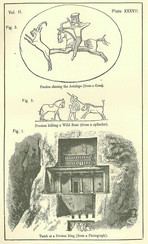
If the tomb were a building, and not rock-hewn, the ground in the vicinity was formed into a park or garden, which was planted with all manner of trees. Within the park, at some little distance from the tomb, was a house, which formed the residence of a body of priests, who watched over the safety of the sepulchre.
The Greeks seem to have believed that divine honors were sometimes paid to a monarch after his decease; but the spirit of the Persian religion was so entirely opposed to any such observance that it is most probable the Greeks were mistaken. Observing that sacrifices were offered once a month in the vicinity of some of the royal tombs, they assumed that the object of the cult was the monarch himself, whereas it was no doubt really addressed either to Ormazd or to Mithras. The Persians cannot rightly be accused of the worship of dead men, a superstition from which both the Zoroastrian and the Magian systems were entirely free.
From this account of the Persian monarchs and their Court, we may now turn to a subject which moderns regard as one of much greater interest—the general condition, manners, and customs of the Persian people. Our information on these points is unfortunately far less full than on the subject which we have been recently discussing, but still it is perhaps sufficient to give us a tolerably complete notion of the real character of the nation.
The Persians, according to Herodotus, were divided into ten tribes, of which four were nomadic and three agricultural. The nomadic were the Dai, the Mardi, the Dropici, and the Sagartii; the agricultural were the Panthilaei, the Derusisei, and the Germanii, or Carmanians. What the occupation of the other three tribes was Herodotus does not state; but, as one of them—the Pasargadae—was evidently the ruling class, consisting, therefore (it is probable), of land owners, who did not themselves till the soil, we may perhaps assume that all three occupied this position, standing in Persia somewhat—as the three tribes of Dorians stood to the other Greeks in the Peloponnese. If this were the case, the population would have been really divided broadly into the two classes of settled and nomade, whereof the former class was subdivided into those who were the lords of the soil, and those who cultivated it, either as farmers or as laborers, under them.
The ordinary dress of the poorer class, whether agricultural or nomade, was probably the tunic and trousers of leather which have been already mentioned as the true national costume of the people. The costume was completed by a loose felt cap upon the head, a strap or belt round the waist, and a pair of high shoes upon the feet, tied in front with a string. [PLATE XXXVIII., Fig. 2.] In later times a linen or muslin rag replaced the felt cap, and the tunic was lengthened so as to reach half way between the knee and the ankle.
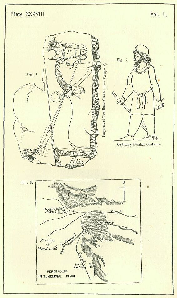
The richer classes seem generally to have adopted the Median costume which was so prevalent at the Court. They wore long purple or flowered robes with loose hanging sleeves, flowered tunics reaching to the knee, also sleeved, embroidered trousers, tiaras, and shoes of a more elegant shape than the ordinary Persian. Nor was this the whole of their dress. Under their trousers they wore drawers, under their tunics shirts, on their hands gloves, and under their shoes socks or stockings—luxuries these, one and all, little known in the ancient world. The Persians were also, like most Orientals, extremely fond of ornaments. Men of rank carried, almost as a matter of course, massive chains or collars of gold about their necks, and bracelets of gold upon their arms. The sheaths and handles of their swords and daggers were generally of gold, sometimes, perhaps, studded with gems. Many of them wore earrings. Great expense was lavished on the trappings of the horses which they rode or drove; the bridle, or at least the bit, was often of solid gold, and the rest of the equipment was costly. Among the gems which were especially affected, the pearl held the first place. Besides being set in the ordinary way, it was bored and strung, in order that it might be used for necklaces, bracelets, and ankles. Even children had sometimes golden ornaments, which were preferred when the gold was of a reddish color.
Very costly and rich too was the furniture of the better class of houses. The tables were plated or inlaid with silver and gold. Splendid couches, spread with gorgeous coverlets, invited the inmates to repose at their ease; and, the better to insure their comfort, the legs of the couches were made to rest upon carpets, which were sufficiently elastic to act as a sort of spring, rendering the couches softer and more luxurious than they would otherwise have been. Gold and silver plate, especially in the shape of drinking-cups, was largely displayed in all the wealthy mansions, each household priding itself on the show which it could make of the precious metals.
In respect of eating and drinking, the Persians, even better sort, were in the earlier times noted for their temperance and sobriety. Their ordinary food was wheaten bread, barley-cakes, and meat simply roasted or boiled, which they seasoned with salt and with bruised cress-seed, a substitute for mustard. The sole drink in which they indulged was water. Moreover, it was their habit to take one meal only each day. The poorer kind of people were contented with even a simpler diet, supporting themselves, to a great extent, on the natural products of the soil, as dates, figs, wild pears, acorns, and the fruit of the terebinth-tree. But these abstemious habits were soon laid aside, and replaced by luxury and self-indulgence, when the success of their arms had put it in their power to have the full and free gratification of all their desires and propensities. Then, although the custom of having but one meal in the day was kept up, the character of the custom was entirely altered by beginning the meal early and making it last till night. Not many sorts of meat were placed on the board, unless the occasion was a grand one; but course after course of the lighter kinds of food flowed on in an almost endless succession, intervals of some length being allowed between the courses to enable the guests to recover their appetites. Instead of water, wine became the usual beverage; each man prided himself on the quantity he could drink; and the natural result followed that most banquets terminated in general intoxication. Drunkenness even came to be a sort of institution. Once a year, at the feast of Mithras, the king of Persia, according to Duris, was bound to be drunk. A general practice arose of deliberating on all important affairs under the influence of wine, so that, in every household, when a family crisis impended, intoxication was a duty.
The Persians ate, not only the meats which we are in the habit of consuming, but also the flesh of goats, horses, asses, and camels. The hump of the last-named animal is considered, even at the present day, a delicacy in many parts of the East; but in ancient Persia it would seem that the entire animal was regarded as fairly palatable. The horse and ass, which no one would touch in modern Persia, were thought, apparently, quite as good eating as the ox; and goats, which were far commoner than sheep, appeared, it is probable, oftener at table. The dietery of a grand house was further varied by the admission into it of poultry and game—the game including wild boars, stags, antelopes, bustards, and probably partridges; the poultry consisting of geese and chickens. Oysters and other fish were used largely as food by the inhabitants of the coast-region.
Grades of society were strongly marked among the Persians; and the etiquette of the Court travelled down to the lowest ranks of the people. Well-known rules determined how each man was to salute his equal, his inferior, or his superior; and the observance of these rules was universal. Inferiors on meeting a decided superior prostrated themselves on the ground; equals kissed each other on the lips; persons nearly but not quite equals kissed each other's cheeks. The usual Oriental rules prevailed as to the intercourse of the sexes. Wives lived in strict seclusion within the walls of the Gynaeceum, or went abroad in litters, seeing no males except their sons, their husbands, and their husbands' eunuchs. Concubines had somewhat more freedom, appearing sometimes at banquets, when they danced, sang, and played to amuse the guests of their master.
The Persian was allowed to marry several wives, and might maintain in addition as many concubines as he thought proper. Most of the richer class had a multitude of each, since every Persian prided himself on the number of his sons, and it is even said that an annual prize was given by the monarch to the Persian who could show most sons living. The concubines were not unfrequently Greeks, if we may judge by the case of the younger Cyrus, who took two Greek concubines with him when he made his expedition against his brother. It would seem that wives did not ordinarily accompany their husbands, when these went on military expeditions, but that concubines were taken to the wars by most Persians of consideration. Every such person had a litter at her disposal, and a number of female attendants, whose business it was to wait upon her and execute her orders.
All the best authorities are agreed that great pains were taken by the Persians—or, at any rate, by those of the leading clans—in the education of their sons. During the first five years of his life the boy remained wholly with the women, and was scarcely, if at all, seen by his father. After that time his training commenced. He was expected to rise before dawn, and to appear at a certain spot, where he was exercised with other boys of his age in running, slinging stones, shooting with the bow, and throwing the javelin. At seven he was taught to ride, and soon afterwards he was allowed to begin to hunt. The riding included, not only the ordinary management of the horse, but the power of jumping on and off his back when he was at speed, and of shooting with the bow and throwing the javelin with unerring aim, while the horse was still at full gallop. The hunting was conducted by state-officers, who aimed at forming by its means in the youths committed to their charge all the qualities needed in war. The boys were made to bear extremes of heat and cold, to perform long marches, to cross rivers without wetting their weapons, to sleep in the open air at night, to be content with a single meal in two days, and to support themselves occasionally on the wild products of the country, acorns, wild pears, and the fruit of the terebinth-tree. On days when there was no hunting they passed their mornings in athletic exercises, and contests with the bow or the javelin, after which they dined simply on the plain food mentioned above as that of the men in the early times, and then employed themselves during the afternoon in occupations regarded as not illiberal—for instance, in the pursuits of agriculture, planting, digging for roots, and the like, or in the construction of arms and hunting implements, such as nets and springes. Hardy and temperate habits being secured by this training, the point of morals on which their preceptors mainly insisted was the rigid observance of truth. Of intellectual education they had but little. It seems to have been no part of the regular training of a Persian youth that he should learn to read. He was given religious notions and a certain amount of moral knowledge by means of legendary poems, in which the deeds of gods and heroes were set before him by his teachers, who recited or sung them in his presence, and afterwards required him to repeat what he had heard, or, at any rate, to give some account of it. This education continued for fifteen years, commencing when the boy was five, and terminating when he reached the age of twenty.
The effect of this training was to render the Persian an excellent soldier and a most accomplished horseman. Accustomed from early boyhood to pass the greater part of every day in the saddle, he never felt so much at home as when mounted upon a prancing steed. On horseback he pursued the stag, the boar, the antelope, even occasionally the bear or the lion, and shot his arrows, or slung his stones, or hurled his javelin at them with deadly aim, never pausing for a moment in his career. [PLATE XXXVII., Fig. 2.] Only when the brute turned on his pursuers, and stood at bay, or charged them in its furious despair, they would sometimes descend from their coursers, and receive the attack, or deal the coup de grace on foot, using for the purpose a short but strong hunting-spear. [PLATE XXXVII., Fig. 3.] The chase was the principal delight of the upper class of Persians, so long as the ancient manners were kept up, and continued an occupation in which the bolder spirits loved to indulge long after decline had set in, and the advance of luxury had changed, to a great extent, the character of the nation.
At fifteen years of age the Persian was considered to have attained to manhood, and was enrolled in the ranks of the army, continuing liable to military service from that time till he reached the age of fifty. Those of the highest rank became the body-guard of the king, and these formed the garrison of the capital. They were a force of not less than fourteen or fifteen thousand men. Others, though liable to military service, did not adopt arms as their profession, but attached themselves to the Court and looked to civil employment, as satraps, secretaries, attendants, ushers, judges, inspectors, messengers. A portion, no doubt, remained in the country districts, and there followed those agricultural pursuits which the Zoroastrian religion regarded as in the highest degree honorable. But the bulk of the nation must, from the time of the great conquests, have passed their lives mainly, like the Roman legionaries under the Empire, in garrison duty in the provinces. The entire population of Persia Proper can scarcely have exceeded two millions. Not more than one fourth of this number would be males between the ages of fifteen and fifty. This body of 500,000 men, besides supplying the official class at the Court and throughout the provinces, and also furnishing to Persia Proper those who did the work of its cultivation, had to supply to the whole Empire those large and numerous garrisons on whose presence depended the maintenance of the Persian dominion in every province that had been conquered. According to Herodotus, the single country of Egypt contained, in his day, a standing army of 120,000 Persians; and, although this was no doubt an exceptional case, Egypt being more prone to revolt than any other satrapy, yet there is abundant evidence that elsewhere, in almost every part of the Empire, large bodies of troops were regularly maintained; troops which are always characterized as "Persians." We may suspect that under the name were included the kindred nation of the Medes, and perhaps some other Arian races, as the Hyrcanians, and the Bactrians, for it is difficult to conceive that such a country as Persia Proper could alone have kept up the military force which the Empire required for its preservation; but to whatever extent the standing army was supplemented from these sources, Persia must still have furnished the bulk of it; and the demands of this service must have absorbed, at the very least, one third if not one half of the adult male population.
For trade and commerce the Persians were wont to express extreme contempt. The richer classes made it their boast that they neither bought nor sold, being supplied (we must suppose) from their estates, and by their slaves and dependents, with all that they needed for the common purposes of life. Persians of the middle rank would condescend to buy, but considered it beneath them to sell; while only the very lowest and poorest were actual artisans and traders. Shops were banished from the more public parts of the towns; and thus such commercial transactions as took place were veiled in what was regarded as a decent obscurity. The reason assigned for this low estimation of trade was that shopping and bargaining involved the necessity of falsehood.
According to Quintus Curtius, the Persian ladies had the same objection to soil their hands with work that the men had to dirty theirs with commerce. The labors of the loom, which no Grecian princess regarded as unbecoming her rank, were despised by all Persian women except the lowest; and we may conclude that the same idle and frivolous gossip which resounds all day in the harems of modern Iran formed the main occupation of the Persian ladies in the time of the Empire.
With the general advance of luxury under Xerxes and his successors, of which something has been already said, there were introduced into the Empire a number of customs of an effeminate and demoralizing character. From the earliest times the Persians seem to have been very careful of their beards and hair, arranging the latter in a vast number of short crisp curls, and partly curling the former, partly training it to hang straight from the chin. After a while, not content with this degree of care for their personal appearance, they proceeded to improve it by wearing false hair in addition to the locks which nature had given them, by the use of cosmetics to increase the delicacy of their complexions, and by the application of a coloring matter to the upper and lower eyelids, for the purpose of giving to the eye an appearance of greater size and beauty. They employed a special class of servants to perform these operations of the toilet, whom the Greeks called "adorners". Their furniture increased, not merely in splendor, but in softness; their floors were covered with carpets, their beds with numerous and delicate coverlets; they could not sit upon the ground unless a cloth was first spread upon it; they would not mount a horse until he was so caparisoned that the seat on his back was softer even than their couches. At the same time they largely augmented the number and variety of their viands and of their sauces, always seeking after novel delicacies, and offering rewards to the inventors of "new pleasures." A useless multitude of lazy menials was maintained in all rich households, each servant confining himself rigidly to a single duty, and porters, bread-makers, cooks, cup-bearers, water-bearers, waiters at table, chamberlains, "awakers," "adorners," all distinct from one another, crowded each noble mansion, helping forward the general demoralization. It was probably at this comparatively late period that certain foreign customs of a sadly lowering character were adopted by this plastic and impressible people, who learnt the vice of paederasty from the Greeks, and adopted from the Assyrians the worship of Beltis, with its accompaniment of religious prostitution.
On the whole the Persians may seem to have enjoyed an existence free from care, and only too prosperous to result in the formation of a high and noble character. They were the foremost Asiatic people of their time, and were fully conscious of their pre-eminency. A small ruling class in a vast Empire, they enjoyed almost a monopoly of office, and were able gradually to draw to themselves much of the wealth of the provinces. Allowed the use of arms, and accustomed to lord it over the provincials, they themselves maintained their self-respect, and showed, even towards the close of their Empire, a spirit and an energy seldom exhibited by any but a free people. But there was nevertheless a dark side to the picture—a lurking danger which must have thrown a shadow over the lives of all the nobler and richer of the nation, unless they were utterly thoughtless. The irresponsible authority and cruel dispositions of the kings, joined to the recklessness with which they delegated the power of life and death to their favorites, made it impossible for any person of eminence in the whole Empire to feel sure that he might not any day be seized and accused of a crime, or even without the form of an accusation be taken and put to death, after suffering the most excruciating tortures. To produce this result, it was enough to have failed through any cause whatever in the performance of a set task, or to have offended, even by doing him too great a service, the monarch or one of his favorites. Nay, it was enough to have provoked, through a relation or a connection, the anger or jealousy of one in favor at Court; for the caprice of an Oriental would sometimes pass over the real culprit and exact vengeance from one quite guiltless—even, it may be, unconscious—of the offence given. Theoretically, the Persian was never to be put to death for a single crime; or at least he was not to suffer until the king had formally considered the whole tenor of his life, and struck a balance between his good and his evil deeds to see which outweighed the other. Practically, the monarch slew with his own hand any one whom he chose, or, if he preferred it, ordered him to instant execution, without trial or inquiry. His wife and his mother indulged themselves in the same pleasing liberty of slaughter, sometimes obtaining his tacit consent to their proceedings, sometimes without consulting him. It may be said that the sufferers could at no time be very many in number, and that therefore no very wide-spread alarm can have been commonly felt; but the horrible nature of many of the punishments, and the impossibility of conjecturing on whom they might next fall, must be set against their infrequency; and it must be remembered that an awful horror, from which no precautions can save a man, though it happen to few, is more terrible than a score of minor perils, against which it is possible to guard. Noble Persians were liable to be beheaded, to be stoned to death, to be suffocated with ashes, to have their tongues torn out by the roots, to be buried alive, to be shot in mere wantonness, to be flayed and then crucified, to be buried all but the head, and to perish by the lingering agony of "the boat." If they escaped these modes of execution, they might be secretly poisoned, or they might be exiled, or transported for life. Their wives and daughters might be seized and horribly mutilated, or buried alive, or cut into a number of fragments. With these perils constantly impending over their heads, the happiness of the nobles can scarcely have been more real than that of Damocles upon the throne of Dionysius.
In conclusion, we may notice as a blot upon the Persian character and
system, the cruelty and barbarity which was exhibited, not only in these
abnormal acts of tyranny and violence, but also in the regular and legal
punishments which were assigned to crimes and offences. The criminal
code, which—rightly enough—made death the penalty of murder, rape,
treason, and rebellion, instead of stopping at this point, proceeded
to visit with a like severity even such offences as deciding a cause
wrongfully on account of a bribe, intruding without permission on the
king's privacy, approaching near to one of his concubines, seating
oneself, even accidentally, on the throne, and the like. The modes of
execution were also, for the most part, unnecessarily cruel. Poisoners
were punished by having their heads placed upon a broad stone, and then
having their faces crushed, and their brains beaten out by repeated
blows with another stone. Ravishers and rebels were put to death by
crucifixion. The horrible punishment of "the boat" seems to have been no
individual tyrant's cruel conception, but a recognized and legal form of
execution. The same may be said also of burying alive. Again the Persian
secondary punishments were for the most part exceedingly barbarous.
Xenophon tells us, as a proof of the good government maintained by the
younger Cyrus, in his satrapy, that under his sway it was common to see
along all the most frequented roads numbers of persons who had had
their hands or feet cut off, or their eyes put out, as a punishment
for thieving and rascality. And other writers relate that similar
mutilations were inflicted on rebels, and even on prisoners of war.
It would seem, indeed, that mutilation and scourging were the ordinary
forms of secondary punishment used by the Persians, who employed
imprisonment solely for the safe custody of an accused person between
his arrest and his execution, while they had recourse to transportation
and exile only in the case of political offenders.
and exile only in the case of political offenders.