[Click on Map to Enlarge]
| CHAPTER I. | DESCRIPTION OF THE COUNTRY |
| CHAPTER II. | CLIMATE AND PRODUCTIONS |
|
49. Signet of Kurri-galzu. King of Babylon (drawn by the author from an impression in the possession of Sir H. Rawlinson) 50. The Khabour, from near Arban, looking north (after Layard) 51. Koukab (ditto) 52. Lake of Khatouniyeh (ditto) 53. Colossal lion, near Seruj (after Chesney) 54. Plan of the ruins of Nimrud (Calah) (reduced by the Author from Captain Jones's survey) 55. Great wound of Nimrud or Calah (after Layard) 56. Hand-swipe, Koyunjik (ditto) 57. Assyrian lion, from Nimrud (ditto) 58. Ibex, or wild goat, from Nimrud (ditto) 59. Wild ass (after Ker Porter) 60. Leopard, from Nimrud (after Layard) 61. Wild ass, from Koyunjik (from an unpublished drawing by Mr. Boutcher in the British Museum) 62. Gazelle, from Nimrud (after Layard) 63. Stag and hind, from Koyunjik (from an unpublished drawing by Mr. Boutcher in the British Museum) 64. Fallow deer, from Koyunjik (after Layard) 65. Hare and eagles, from Nimrud (ditto) 66. Hare, from Khorsabad (after Botta) 67. Chase of wild ox, from Nimrud (after Layard) 68. Vulture, from Nimrud (ditto) 69. Vulture feeding on corpse, Koyunjik (ditto) 70. Ostrich, from a cylinder (after Cullimore) 71. Ostrich, from Nimrud (after Layard) 72. Partridges, from Khorsabad (after Botta) 73. Unknown birds, Khorsabad (ditto) 74. Assyrian garden and fish-pond, Koyunjik (after Layard) 75. Bactrian or two-humped camel, from Nimrud (ditto) 76. Mesopotamian sheep (ditto) 77. Loading a camel, Koyunjik (ditto) 78. Head of an Assyrian horse, Koyunjik (ditto) 79. Assyrian horse, from Nimrud (ditto) 80. Mule ridden by two women, Koyunjik (after Layard 81. Loaded mule, Koyunjik (ditto) 82. Cart drawn by mules, Koyunjik (ditto) 83. Dog modelled in clay, from the palace of Asshur-bani-pal, Koyunjik, (drawn by the Author from the original in the British Museum) 84. Dog in relief, on a clay tablet (after Layard) 85. Assyrian cluck, Nimrud (ditto) 86. Assyrians, Nimrud (ditto) |
"Greek phrase[—]"—HEROD. i. 192.
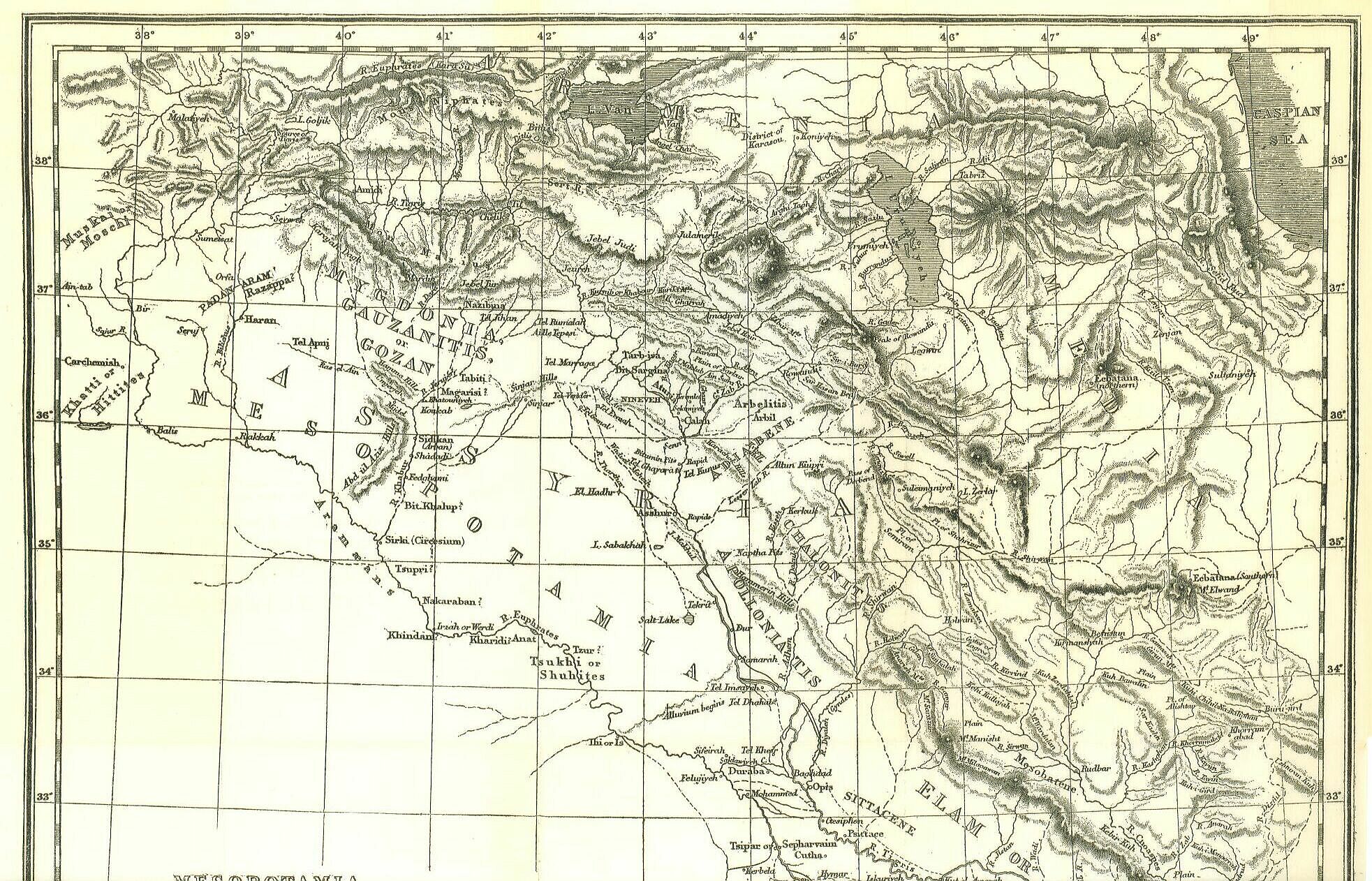
The site of the second—or great Assyrian-monarchy was the upper portion of the Mesopotamian valley. The cities which successively formed its capitals lay, all of them, upon the middle Tigris; and the heart of the country was a district on either side that river, enclosed within the thirty-fifth and thirty-seventh parallels. By degrees these limits were enlarged; and the term Assyria came to be used, in a loose and vague way, of a vast and ill-defined tract extending on all sides from this central region. Herodotus considered the whole of Babylonia to be a mere district of Assyria. Pliny reckoned to it all Mesopotamia. Strabo gave it, besides these regions, a great portion of Mount Zagros (the modern Kurdistan), and all Syria as far as Cilicia, Judaea, and Phoenicia.
If, leaving the conventional, which is thus vague and unsatisfactory, we seek to find certain natural limits which we may regard as the proper boundaries of the country, in two directions we seem to perceive an almost unmistakable line of demarcation. On the east the high mountain-chain of Zagros. penetrable only in one or two places, forms a barrier of the most marked character, and is beyond a doubt the natural limit for which we are looking. On the south a less striking, but not less clearly defined, line—formed by the abutment of the upper and slightly elevated plain on the alluvium of the lower valley—separates Assyria from Babylonia, which is best regarded as a distinct country. In the two remaining directions, there is more doubt as to the most proper limit. Northwards,we may either view Mount Masius as the natural boundary, or the course of the Tigris from Diarbekr to Til, or even perhaps the Armenian mountain-chain north of this portion of the Tigris, from whence that river receives its early tributaries. Westward, we might confine Assyria to the country watered by the affluents of the Tigris, or extend it so as to in elude the Khabour and its tributaries, or finally venture to carry it across the whole of Mesopotamia, and make it be bounded by the Euphrates. On the whole it is thought that in both the doubted cases the wider limits are historically the truer ones. Assyrian remains cover the entire country between the Tigris and the Khabour, and are frequent on both banks of the latter stream, giving unmistakable indications of a long occupation of that region by the great Mesopotamian people. The inscriptions show that even a wider tract was in process of time absorbed by the conquerors; and if we are to draw a line between the country actually taken into Assyria, and that which was merely conquered and held in subjection, we can select no better boundary than the Euphrates westward, and northward the snowy mountain-chain known to the ancients as Mons Niphates.
If Assyria be allowed the extent which is here assigned to her, she will be a country, not only very much larger than Chaldaea or Babylonia, but positively of considerable dimensions. Reaching on the north to the thirty-eighth and on the south to the thirty-fourth parallel, she had a length diagonally from Diarbekr to the alluvium of 350 miles, and a breadth between the Euphrates and Mount Zagros varying from about 300 to 170 miles. Her area was probably not less than 75,000 square miles, which is more than double that of Portugal, and not much below that of Great Britain. She would thus from her mere size be calculated to play an important (part) in history; and the more so, as during the period of her greatness scarcely any nation with which she came in contact possessed nearly so extensive a territory.
Within the limits here assigned to Assyria, the face of the country is tolerably varied. Possessing, on the whole, perhaps, a predominant character of flatness, the territory still includes some important ranges of hills, while on the two sides it abuts upon lofty mountain-chains. Towards the north and east it is provided by nature with an ample supply of water, rills everywhere flowing from the Armenian and Kurdish ranges, which soon collect into rapid and abundant rivers. The central, southern, and western regions are, however, less bountifully supplied; for though the Euphrates washes the whole western and south-western frontier, it spreads fertility only along its banks; and though Mount Masius sends down upon the Mesopotamian plain a considerable number of streams, they form in the space of 200 miles between Balls and Mosul but two rivers, leaving thus large tracts to languish for want of the precious fluid. The vicinity of the Arabian and Syrian deserts is likewise felt in these regions, which, left to themselves, tend to acquire the desert character, and have occasionally been regarded as actual parts of Arabia.
The chief natural division of the country is that made by the Tigris, which, having a course nearly from north to south, between Til and Samarah, separates Assyria into a western and an eastern district. Of these two, the eastern or that upon the left bank of the Tigris, although considerably the smaller, has always been the more important region. Comparatively narrow at first, it broadens as the course of the river is descended, till it attains about the thirty-fifth parallel a width of 130 or 140 miles. It consists chiefly of a series of rich and productive plains, lying along the courses of the various tributaries which flow from Mount Zagros into the Tigris, and often of a semi-alluvial character. These plains are not, however, continuous. Detached ranges of hills, with a general direction parallel to the Zagros chain, intersect the flat rich country, separating the plains from one another, and supplying small streams and brooks in addition to the various rivers, which, rising within or beyond the great mountain barriers, traverse the plains on their way to the Tigris. The hills themselves—known now as the Jebel Maklub, the Ain-es-sufra, the Karachok, etc.—are for the most part bare and sterile. In form they are hogbacked, and viewed from a distance have a smooth and even outline but on a nearer approach they are found to be rocky and rugged. Their limestone sides are furrowed by innumerable ravines, and have a dry and parched appearance, being even in spring generally naked and without vegetation. The sterility is most marked on the western flank, which faces the hot rays of the afternoon sun; the eastern slope is occasionally robed with a scanty covering of dwarf oak or stunted brushwood. In the fat soil of the plains the rivers commonly run deep and concealed from view, unless in the spring and the early summer, when through the rains and the melting of the snows in the mountains they are greatly swollen, and run bank full, or even overflow the level country.
The most important of these rivers are the following:—the Kurnib or Eastern Khabour, which joins the Tigris in lat. 37° 12'; the Greater Zab (Zab Ala), which washes the ruins of Nimrud, and enters the main stream almost exactly in lat. 30°; the Lesser Zab (Zab Asfal), which effects its junction about lat. 35° 15'; the Adhem, which is received a little below Samarah, about lat. 34°; and the Diyaleh, which now joins below Baghdad, but from which branches have sometimes entered the Tigris a very little below the mouth of the Adhem. Of these streams the most northern, the Khabour, runs chiefly in an untraversed country—the district between Julamerik and the Tigris. It rises a little west of Julamerik in one of the highest mountain districts of Kurdistan, and runs with a general south-westerly course to its junction with another large branch, which reaches it from the district immediately west of Amadiyeh; it then flows due west, or a little north of west, to Zakko, and, bending to the north after passing that place, flows once more in a south-westerly direction until it reaches the Tigris. The direct distance from its source to its embouchure is about 80 miles; but that distance is more than doubled by its windings. It is a stream of considerable size, broad and rapid; at many seasons not fordable at all, and always forded with difficulty.
The Greater Zab is the most important of all the tributaries of the Tigris. It rises near Konia, in the district of Karasu, about lat. 32° 20', long. 44° 30', a little west of the watershed which divides the basins of Lakes Van and Urymiyeh. Its general course for the first 150 miles is S.S.W., after which for 25 or 30 miles it runs almost due south through the country of the Tiyari. Near Amadiyeh it makes a sudden turn, and flows S.E. or S.S.E. to its junction with the Rowandiz branch whence, finally, it resumes its old direction, and runs south-west past the Nimrud ruins into the Tigris. Its entire course, exclusive of small windings, is above 350 miles, and of these nearly 100 are across the plain country, which it enters soon after receiving the Rowandiz stream. Like the Khabour, it is fordable at certain places and during the summer season; but even then the water reaches above the bellies of horses. It is 20 yards wide a little above its junction with the main steam. On account of its strength and rapidity the Arabs sometimes call it the "Mad River."
The Lesser Zab has its principal source near Legwin, about twenty miles south of Lake Urumiyeh, in lat. 36° 40', long. 46° 25'. The source is to the east of the great Zagros chain; and it might have been supposed that the waters would necessarily flow northward or eastward, towards Lake Urumiyeh, or towards the Caspian. But the Legwin river, called even at its source the Zei or Zab, flows from the first westward, as if determined to pierce the mountain barrier. Failing, however, to find an opening where it meets the range, the Little Zab turns south and even south-east along its base, till about 25 or 30 miles from its source it suddenly resumes its original direction, enters the mountains in lat. 36° 20', and forces its way through the numerous parallel ranges, flowing generally to the S.S.W., till it debouches upon the plain near Arbela, after which it runs S.W. and S.W. by S. to the Tigris. Its course among the mountains is from 80 to 90 miles, exclusive of small windings; and it runs more than 100 miles through the plain. Its ordinary width, just above its confluence with the Tigris, is 25 feet.
The Diyaleh, which lies mostly within the limits that have been here assigned to Assyria, is formed by the confluence of two principal streams, known respectively as the Holwan, and the Shirwan, river. Of these, the Shirwan seems to be the main branch. This stream rises from the most eastern and highest of the Zagros ranges, in lat. 34° 45', long. 47° 40' nearly. It flows at first west, and then north-west, parallel to the chain, but on entering the plain of Shahrizur, where tributaries join it from the north-east and the north-west, the Shirwan changes its course and begins to run south of west, a direction, which, it pursues till it enters the low country, about lat. 35° 5', near Semiram. Thence to the Tigris it has a course which in direct distance is 150 miles, and 200 if we include only main windings. The whole course cannot be less than 380 miles, which is about the length of the Great Zab river. The width attained before the confluence with the Tigris is 60 yards, or three times the width of the Greater, and seven times that of the Lesser Zab.
On the opposite side of the Tigris, the traveller comes upon a region far less favored by nature than that of which we have been lately speaking. Western Assyria has but a scanty supply of water; and unless the labor of man is skilfully applied to compensate this natural deficiency, the greater part of the region tends to be, for ten months out of the twelve, a desert. The general character of the country is level, but not alluvial. A line of mountains, rocky and precipitous, but of no great elevation, stretches across the northern part of the region, running nearly due east and west, and extending from the Euphrates at Rum-kaleh to Til and Chelek upon the Tigris. Below this, a vast slightly undulating plain extends from the northern mountains to the Babylonian alluvium, only interrupted about midway by a range of low limestone hills called the Sinjar, which leaving the Tigris near Mosul runs nearly from east to west across central Mesopotamia, and strikes the Euphrates half-way between Rakkeh and Kerkesiyeh, nearly in long. 40°.
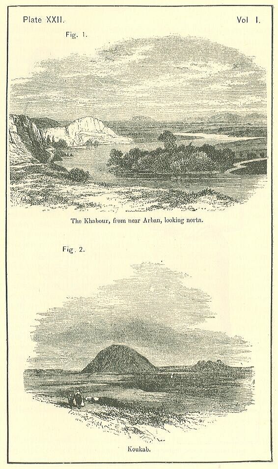
The northern mountain region, called by Strabo "Mons Masius," and by the Arabs the Karajah Dagh towards the west, and towards the east the Jebel Tur, is on the whole a tolerably fertile country. It contains a good deal of rocky land; but has abundant springs, and in many parts is well wooded. Towards the west it is rather hilly than mountainous; but towards the east it rises considerably, and the cone above Mardin is both lofty and striking. The waters flowing from the range consist, on the north, of a small number of brooks, which after a short course fall into the Tigris; on the south, of more numerous and more copious streams, which gradually unite, and eventually form two rather important rivers. These rivers are the Belik, known anciently as the Bileeha, and the Western Khabour, called Habor in Scripture, and by the classical writers Aborrhas or Chaboras. [PLATE XXII., Fig. 1.]
The Belik rises among the hills east of Orfa, about long. 39°, lat. 37° 10'. Its course is at first somewhat east of south; but it soon sweeps round, and, passing by the city of Harran—the Haran of Scripture and the classical Carrh—proceeds nearly due south to its junction, a few miles below Rakkah, with the Euphrates. It is a small stream throughout its whole course, which may be reckoned at 100 or 120 miles.
The Khabour is a much more considerable river. It collects the waters which flow southward from at least two-thirds of the Mons Masius, and has, besides, an important source, which the Arabs regard as the true "head of the spring," derived apparently from a spur of the Sinjar range. This stream, which rises about lat. 36° 40', long. 40°, flows a little south of east to its junction near Koukab with the Jerujer or river Nisi-his, which comes down from Mons Masius with a course not much west of south. Both of these branches are formed by the union of a number of streams. Neither of them is fordable for some distance above their junction; and below it, they constitute a river of such magnitude as to be navigable for a considerable distance by steamers. The course of the Khabour below Koukab is tortuous; but its general direction is S.S.W. The entire length of the stream is certainly not less than 200 miles.
The country between the "Mons Masius" and the Sinjar range is an undulating plain, from 60 to 70 miles in width, almost as devoid of geographical features as the alluvium of Babylonia. From a height the whole appears to be a dead level: but the traveller finds, on descending, that the surface, like that of the American prairies and the Roman Campagna, really rises and falls in a manner which offers a decided contrast to the alluvial flats nearer the sea. Great portions of the tract are very deficient in water. Only small streams descend from the Sinjar range, and these are soon absorbed by the thirsty soil; so that except in the immediate vicinity of the hills north and south, and along the courses of the Khabour, the Belik, and their affluents, there is little natural fertility, and cultivation is difficult. The soil too is often gypsiferous, and its salt and nitrous exudations destroy vegetation; while at the same time the streams and springs are from the same cause for the most part brackish and unpalatable. Volcanic action probably did not cease in the region very much, if at all, before the historical period. Fragments of basalt in many places strew the plain; and near the confluence of the two chief branches of the Khabour, not only are old craters of volcanoes distinctly visible, but a cone still rises from the centre of one, precisely like the cones in the craters of Etna and Vesuvius, composed entirely of loose lava, scorim, and ashes, and rising to the height of 300 feet. The name of this remarkable hill, which is Koukab, is even thought to imply that the volcano may have been active within the time to which the traditions of the country extend. [PLATE XXII., Fig. 2.]
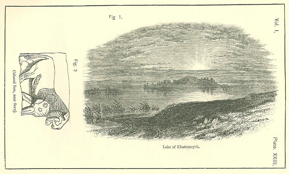
Sheets of water are so rare in this region that the small lake of Khatouniyeh seems to deserve especial description. This lake is situated near the point where the Sinjar changes its character, and from a high rocky range subsides into low broken hills. It is of oblong shape, with its greater axis pointing nearly due east and west, in length about four miles, and in its greatest breadth somewhat less than three. [PLATE XXIII., Fig. 1] The banks are low and parts marshy, more especially on the side towards the Khabour, which is not more than ten miles distant. In the middle of the lake is a hilly peninsula, joined to the mainland by a narrow causeway, and beyond it a small island covered with trees. The lake abounds with fish and waterfowl; and its water, though brackish, is regarded as remarkably wholesome both for man and beast.
The Sinjar range, which divides Western Assyria into two plains, a northern and a southern, is a solitary limestone ridge, rising up abruptly from the flat country, which it commands to a vast distance on both sides. The limestone of which it is composed is white, soft, and fossiliferous; it detaches itself in enormous flakes from the mountain-sides, which are sometimes broken into a succession of gigantic steps, while occasionally they present the columnar appearance of basalt. The flanks of the Sinjar are seamed with innumerable ravines, and from these small brooks issue, which are soon dispersed by irrigation, or absorbed in the thirsty plains. The sides of the mountain are capable of being cultivated by means of terraces, and produce fair crops of corn and excellent fruit; the top is often wooded with fruit trees or forest-trees. Geographically, the Sinjar may be regarded as the continuation of that range of hills which shuts in the Tigris on the west, from Tekrit nearly to Mosul, and then leaving the river strikes across the plain in a direction almost from east to west as far as the town of Sinjar. Here the mountains change their course and bend to the south-west, till having passed the little lake described above, they somewhat suddenly subside, sinking from a high ridge into low undulating hills, which pass to the south of the lake, and then disappear in the plain altogether. According to some, the Sinjar here terminates; but perhaps it is best to regard it as rising again in the Abd-el-aziz hills, which, intervening between the Khabour and the Euphrates, run in the same south-west direction from Arban to Zelabi. If this be accepted as the true course of the Sinjar, we must view it as throwing out two important spurs. One of these is near its eastern extremity, and runs to the south-east, dividing the plain of Zerga from the great central level. Like the main chain, it is of limestone; and, though low, has several remarkable peaks which serve as landmarks from a vast distance. The Arabs call it Kebritiyeh, or "the Sulphur range," from a sulphurous spring which rises at its foot. The other spur is thrown out near the western extremity, and runs towards the north-west, parallel to the course of the upper Khabour, which rises from its flank at Ras-el-Ain. The name of Abd-el-aziz is applied to this spur, as well as to the continuation of the Sinjar between Arban and Halebi. It is broken into innumerable valleys and ravines, abounding with wild animals, and is scantily wooded with dwarf oak. Streams of water abound in it.
South of the Sinjar range, the country resumes the same level appearance which characterizes it between the Sinjar and the Mons Masius. A low limestone ridge skirts the Tigris valley from Mosul to Tekrit, and near the Euphrates the country is sometimes slightly hilly; but generally the eye travels over a vast slightly undulating level, unbroken by eminences, and supporting but a scanty vegetation. The description of Xenophon a little exaggerates the flatness, but is otherwise faithful enough:—"In these parts the country was a plain throughout, as smooth as the sea, and full of wormwood; if any other shrub or reed grew there, it had a sweet aromatic smell; but there was not a tree in the whole region." Water is still more scarce than in the plains north of the Sinjar. The brooks descending from that range are so weak that they generally lose themselves in the plain before they have run many miles. In one case only do they seem sufficiently strong to form a river. The Tharthar, which flows by the ruins of El Hadhr, is at that place a considerable stream, not indeed very wide but so deep that horses have to swim across it. Its course above El Hadhr has not been traced; but the most probable conjecture seems to be that it is a continuation of the Sinjar river, which rises about the middle of the range, in long. 41° 50', and flows south-east through the desert. The Tharthar appears at one time to have reached the Tigris near Tekrit, but it now ends in a marsh or lake to the south-west of that city.
The political geography of Assyria need not occupy much of our attention. There is no native evidence that in the time of the great monarchy the country was formally divided into districts, to which any particular names were attached, or which were regarded as politically separate from one another; nor do such divisions appear in the classical writers until the time of the later geographers, Strabo, Dionysius, and Ptolemy. If it were not that mention is made in the Old Testament of certain districts within the region which has been here termed Assyria, we should have no proof that in the early times any divisions at all had been recognized. The names, however, of Padan-Aram, Aram-Naharaim, Gozan, Halah, and (perhaps) Huzzab, designate in Scripture particular portions of the Assyrian territory; and as these portions appear to correspond in some degree with the divisions of the classical geographers, we are led to suspect that these writers may in many, if not in most cases, have followed ancient and native traditions or authorities. The principal divisions of the classical geographers will therefore be noticed briefly, so far at least as they are intelligible.
According to Strabo, the district within which Nineveh stood was called Aturia, which seems to be the word Assyria slightly corrupted, as we know that it habitually was by the Persians. The neighboring plain country he divides into four regions—Dolomene, Calachene, Chazene, and Adiabene. Of Dolomene, which Strabo mentions but in one place, and which is wholly omitted by other authors, no account can be given. Calachene, which is perhaps the Calacine of Ptolemy, must be the tract about Calah (Nimrud), or the country immediately north of the Upper Zab river. Chazene, like Dolomene, is a term which cannot be explained. Adiabene, on the contrary, is a well-known geographical expression. It is the country of the Zab or Diab rivers, and either includes the whole of Eastern Assyria between the mountains and the Tigris, or more strictly is applied to the region between the Upper and Lower Zab, which consists of two large plains separated from each other by the Karachok hills. In this way Arbelitis, the plain between the Karachok and Zagros, would fall within Adiabene, but it is sometimes made a distinct region, in which case Adiabene must be restricted to the flat between the two Zabs, the Tigris, and the harachok. Chalonitis and Apolloniatis, which Strabo seems to place between these northern plains and Susiana, must be regarded as dividing between them the country south of the Lesser Zab, Apolloniatis (so called from its Greek capital, Apollonia) lying along the Tigris, and Chalonitis along the mountains from the pass of Derbend to Gilan. Chalonitis seems to have taken its name from a capital city called Chala, which lay on the great route connecting Babylon with the southern Ecbatana, and in later times was known as Holwan. Below Apolloniatis, and (like that district) skirting the Tigris, was Sittacene, (so named from its capital, Sittace which is commonly reckoned to Assyria, but seems more properly regarded as Susianian territory.) Such are the chief divisions of Assyria east of the Tigris.
West of the Tigris, the name Mesopotamia is commonly used, like the Aram-Naharaim of the Hebrews, for the whole country between the two great rivers. Here are again several districts, of which little is known, as Acabene, Tigene, and Ancobaritis. Towards the north, along the flanks of Mons Masius from Nisibis to the Euphrates, Strabo seems to place the Mygdonians, and to regard the country as Mygdonia. Below Mygdonia, towards the west, he puts Anthemusia, which he extends as far as the Khabour river. The region south of the Khabour and the Sinjar he seems to regard as inhabited entirely by Arabs. Ptolemy has, in lieu of the Mygdonia of Strabo, a district which he calls Gauzanitis; and this name is on good grounds identified with the Gozan of Scripture, the true original probably of the "Mygdonia" of the Greeks. Gozan appears to represent the whole of the upper country from which the longer affluents of the Khabour spring; while Halah, which is coupled with it in Scripture, and which Ptolemy calls Chalcitis, and makes border on Gauzanitis, may designate the tract upon the main stream, as it comes down from Ras-el-Ain. The region about the upper sources of the Belik has no special designation in Strabo, but in Scripture it seems to be called Padan-Aram, a name which has been explained as "the flat Syria," or "the country stretching out from the foot of the hills." In the later Roman times it was known as Osrhoene; but this name was scarcely in use before the time of the Antonines.
The true heart of Assyria was the country close along the Tigris, from lat. 35° to 36° 30'. Within these limits were the four great cities, marked by the mounds at Khorsabad, Mosul, Nimrud, and Kileh-Sherghat, besides a multitude of places of inferior consequence. It has been generally supposed that the left bank of the river was more properly Assyria than the right; and the idea is so far correct, as that the left bank was in truth of primary value and importance, whence it naturally happened that three out of the four capitals were built on that side of the stream. Still the very fact that one early capital was on the right bank is enough to show that both shores of the stream were alike occupied by the race from the first; and this conclusion is abundantly confirmed by other indications throughout the region. Assyrian ruins, the remains of considerable towns, strew the whole country between the Tigris and Khabour, both north and south of the Sin jar range. On the banks of the Lower Khabour are the remains of a royal palace, besides many other traces of the tract through which it runs having been permanently occupied by the Assyrian people. Mounds, probably Assyrian, are known to exist along the course of the Khabour's great western affluent; and even near Seruj, in the country between Harlan and the Euphrates some evidence has been found not only of conquest but of occupation. Remains are perhaps more frequent on the opposite side of the Tigris; at any rate they are more striking and more important. Bavian, Khorsabad, Shereef-Khan, Neb-bi-Yunus, Koyunjik, and Nimrud, which have furnished by far the most valuable and interesting of the Assyrian monuments, all lie east of the Tigris; while on the west two places only have yielded relics worthy to be compared with these, Arban and Kileh-Sherghat.
It is curious that in Assyria, as in early Chaldaea, there is a special pre-eminence of four cities. An indication of this might seem to be contained in Genesis, where Asshur is said to have "builded Nineveh," and the city Rehoboth, and Calah, and Resen; but on the whole it is more probable that we have here a mistranslation (which is corrected for us in the margin), and that three cities only are ascribed by Moses to the great patriarch. In the flourishing period of the empire, however, we actually find four capitals, of which the native names seem to have been Ninua, Calah, Asshur, and Bit-Sargina, or Dur-Sargina (the city of Sargon)—all places of first-rate consequence. Besides these principal cities, which were the sole seats of government, Assyria contained a vast number of large towns, few of which it is possible to name, but so numerous that they cover the whole face of the country with their ruins. Amomig; them were Tarbisa, Arbil, Arapkha, and Khazeh, in the tract between the Tigris and Mount Zagros; Haran, Tel-Apni, Razappa (Rezeph), and Amida, towards the north-west frontier; Nazibina (Nisibis), on the eastern branch of the Khabour; Sirki (Circesium), at the confluence of the Khabour with the Euphrates; Anat, on the Euphrates, some way below this junction; Tabiti, Magarisi, Sidikan, Katni, Beth-Khalupi,etc., in the district south of the Sinjar, between the lower course of the Khabour and the Tigris. Here, again, as in the case of Chaldaea, it is impossible at present to locate with accuracy all the cities. We must once more confine ourselves to the most important, mind seek to determine, either absolutely or with a certain vagueness, their several positions.
It admits of no reasonable doubt that the ruins opposite Mosul are those of Nineveh. The name of Nineveh is read on the bricks; and a uniform tradition, reaching from the Arab conquest to comparatively recent times, attaches to the mounds themselves the same title. They are the most extensive ruins in Assyria; and their geographical position suits perfectly all the notices of the geographers and historians with respect to the great Assyrian capital. As a subsequent chapter will be devoted to a description of this famous city, it is enough in this place to observe that it was situated on the left or east bank of the Tigris, in lat. 36° 21', at the point where a considerable brook, the Khosr-su, falls into the main stream. On its west flank flowed the broad and rapid Tigris, the "arrow-stream," as we may translate the word; while north, east, and south, expanded the vast undulating plain which intervenes between the river and the Zagros mountain-range. Mid-way in this plain, at the distance of from 15 to 18 miles from the city, stood boldly up the Jabel Maklub and Ain Sufra hills, calcareous ridges rising nearly 2000 feet above the level of the Tigris, and forming by far the most prominent objects in the natural landscape. Inside the Ain Sufra, and parallel to it, ran the small stream of the Gomel, or Ghazir, like a ditch skirting a wall, an additional defence in that quarter. On the south-east and south, distant about fifteen miles, was the strong and impetuous current of the Upper Zab, completing the natural defences of the position which was excellently chosen to be the site of a great capital.
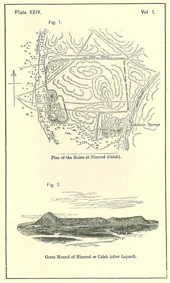
South of Nineveh, at the distance of about twenty miles by the direct route and thirty by the course of the Tigris, stood the second city of the empire, Calah, the site of which is marked by the extensive ruins at Nimrud. [PLATE XXIV., Fig. 1.] Broadly, this place may be said to have been built at the confluence of the Tigris with the Upper Zab; but in strictness it was on the Tigris only, the Zab flowing five or six miles further to the south, and entering the Tigris at least nine miles below the Nimrud ruins. These ruins at present occupy an area somewhat short of a thousand English acres, which is little more than one-half of the area of the ruins of Nineveh; but it is thought that the place was in ancient times considerably larger, and that the united action of the Tigris and some winter streams has swept away no small portion of the ruins. They form at present an irregular quadrangle, the sides of which face the four cardinal points. On the north and east the rampart may still be distinctly traced. It was flanked with towers along its whole course, and pierced at uncertain intervals by gates, but was nowhere of very great strength or dimensions. On the south side it must have been especially weak, for there it has disappeared altogether. Here, however, it seems probable that the Tigris and the Shor Derreh stream, to which the present obliteration of the wall may be ascribed, formed in ancient times a sufficient protection. Towards the west, it seems to be certain that the Tigris (which is now a mile off) anciently flowed close to the city. On this side, directly facing the river, and extending along it a distance of 600 yards, or more than a third of a mile, was the royal quarter, or portion of the city occupied by the palaces of the kings. It consisted of a raised platform, forty feet above the level of the plain, composed in some parts of rubbish, in others of regular layers of sun-dried bricks, and cased on every side with solid stone masonry, containing an area of sixty English acres, and in shape almost a regular rectangle, 560 yards long, and from 350 to 450 broad. The platform was protected at its edges by a parapet, and is thought to have been ascended in various places by wide staircases, or inclined ways, leading up from the plain. The greater part of its area is occupied by the remains of palaces constructed by various native kings, of which a more particular account will be given in the chapter on the architecture and other arts of the Assyrians. It contains also the ruins of two small temples, and abuts at its north-western angle on the most singular structure which has as yet been discovered among the remains of the Assyrian cities. This is the famous tower or pyramid which looms so conspicuously over the Assyrian plams, and which has always attracted the special notice of the traveller. [PLATE XXIV., Fig. 2.] An exact description of this remarkable edifice will be given hereafter.
It appears from the inscriptions on its bricks to have been commenced by one of the early kings, and completed by another. Its internal structure has led to the supposition that it was designed to be a place of burial for one or other of these monarchs. Another conjecture is, that it was a watch-tower; but this seems very unlikely, since no trace of any mode by which it could be ascended has been discovered.
Forty miles below Calah, on the opposite bank of the Tigris, was a third great city, the native name of which appears to have been Asshur. This place is represented by the ruins at Kileh-Sherghat, which are scarcely inferior in extent to those at Nimrud or Calah. It will not be necessary to describe minutely this site, as in general character it closely resembles the other ruins of Assyria. Long lines of low mounds mark the position of the old walls, and show that the shape of the city was quadrangular. The chief object is a large square mound or platform, two miles and a half in circumference, and in places a hundred feet above the level of the plain, composed in part of sun-dried bricks, in part of natural eminences, and exhibiting occasionally remains of a casing of hewn stone, which may once have encircled the whole structure. About midway on the north side of the platform, and close upon its edge, is a high cone or pyramid. The rest of the platform is covered with the remains of walls and with heaps of rubbish, but does not show much trace of important buildings. This city has been supposed to represent the Biblical Resen; but the description of that place as lying "between Nineveh and Calah" seems to render the identification worse than uncertain.
The ruins at Kileh-Sherghat are the last of any extent towards the south, possessing a decidedly Assyrian character. To complete our survey, therefore of the chief Assyrian towns, we must return northwards, and, passing Nineveh, direct our attention to the magnificent ruins on the small stream of the Khosrsu, which have made the Arab village of Khorsabad one of the best known names in Oriental topography. About nine miles from the north-east angle of the wall of Nineveh, in a direction a very little east of north, stands the ruin known as Khorsabad, from a small village which formerly occupied its summit—the scene of the labors of M. Botta, who was the first to disentomb from among the mounds of Mesopotamia the relics of an Assyrian palace. The enclosure at Khorsabad is nearly square in shape, each side being about 2000 yards long. No part of it is very lofty, but the walls are on every side well marked. Their angles point towards the cardinal points, or nearly so; and the walls themselves consequently face the north-east, the north-west, the south-west, and the south-east. Towards the middle of the north-west wall, and projecting considerably beyond it, was a raised platform of the usual character; and here stood the great palace, which is thought to have been open to the plain, and on that side quite undefended.
Four miles only from Khorsabad, in a direction a little west of north, are the ruins of a smaller Assyrian city, whose native name appears to have been Tarbisa, situated not far from the modern village of Sherif-khan. Here was a palace, built by Esarhaddon for one of his sons, as well as several temples and other edifices. In the opposite direction at the distance of about twenty miles, is Keremles, an Assyrian ruin, whose name cannot yet be rendered phonetically. West of this site, and about half-way between the ruins of Nineveh and Nimrud or Calah, is Selamiyah, a village of some size, the walls of which are thought to be of Assyrian construction. We may conjecture that this place was the Resen, or Dase, of Holy Scripture, which is said to have been a large city, interposed between Nineveh and Calah. In the same latitude, but considerably further to the east, was the famous city of Arabil or Arbil, known to the Greeks as Arbela, and to this day retaining its ancient appellation. These were the principal towns, whose positions can be fixed, belonging to Assyria Proper, or the tract in the immediate vicinity of Nineveh.
Besides these places, the inscriptions mention a large number of cities which we cannot definitely connect with any particular site. Such are Zaban and Zadu, beyond the Lower Zab, probably somewhere in the vicinity of Kerkuk; Kurban, Tidu (?), Napulu, Kapa, in Adiabene; Arapkha and Khaparkhu, the former of which names recalls the Arrapachitis of Ptolemy, in the district about Arbela; Hurakha, Sallat (?), Dur-Tila, Dariga, Lupdu, and many others, concerning whose situations it is not even possible to make any reasonable conjecture. The whole country between the Tigris and the mountains was evidently studded thickly with towns, as it is at the present day with ruins; but until a minute and searching examination of the entire region has taken place, it is idle to attempt an assignment to particular localities of these comparatively obscure names.
In Western Assyria, or the tract on the right bank of the Tigris, while there is reason to believe that population was as dense, and that cities were as numerous, as on the opposite side of the river, even fewer sites can be determinately fixed, owing to the early decay of population in those parts, which seem to have fallen into their present desert condition shortly after the destruction of the Assyrian empire by the conquering Medes. Besides Asshur, which is fixed to the ruins at Kileh-Sherghat, we can only locate with certainty some half-dozen places. These are Nazibina, which is the modern Nisibin, the Nisibis of the Greeks; Amidi, which is Amida or Diarbekr; Haran, which retains its name unchanged; Sirki, which is the Greek Circesium, now Kerkesiyeh; Anat, now Anah, on an island in the Euphrates; and Sidikan, now Arban, on the Lower Khabour. The other known towns of this region, whose exact position is more or less uncertain, are the following:—Tavnusir, which is perhaps Dunisir, near Mardin; Guzana, or Gozan, in the vicinity of Nisibin; Razappa, or Rezeph, probably not far from Harran; Tel Apni, about Orfah or Ras-el-Ain; Tabiti and Magarisi, on the Jerujer, or river of Nisibin; Katni and Beth-Khalupi, on the Lower Khabour; Tsupri and Nakarabani, on the Euphrates, between its junction with the Khabour and Allah; and Khuzirina, in the mountains near the source of the Tigris. Besides these, the inscriptions contain a mention of some scores of towns wholly obscure, concerning which we cannot even determine whether they lay west or east of the Tigris.
Such are the chief geographical features of Assyria. It remains to notice briefly the countries by which it was bordered. To the east lay the mountain region of Zagros, inhabited principally, during the earlier times of the Empire, by the Zimri, and afterwards occupied by the Medes, and known as a portion of Media. This region is one of great strength, and at the same time of much productiveness and fertility. Composed of a large number of parallel ridges. Zagros contains, besides rocky and snow-clad summits, a multitude of fertile valleys, watered by the great affluents of the Tigris or their tributaries, and capable of producing rich crops with very little cultivation. The sides of the hills are in most parts clothed with forests of walnut, oak, ash, plane, and sycamore, while mulberries, olives, and other fruit-trees abound; in many places the pasturage is excellent; and thus, notwithstanding its mountainous character, the tract will bear a large population. Its defensive strength is immense, equalling that of Switzerland before military roads were constructed across the High Alps. The few passes by which it can be traversed seem, according to the graphic phraseology of the ancients, to be carried up ladders; they surmount six or seven successive ridges, often reaching the elevation of 10,000 feet, and are only open during seven months of the year. Nature appears to have intended Zagros as a seven fold wall for the protection of the fertile Mesopotamian lowland from the marauding tribes inhabiting the bare plateau of Iran.
North of Assyria lays a country very similar to the Zagros region. Armenia, like Kurdistan, consists, for the most part of a number of parallel mountain ranges, with deep valleys between them, watered by great rivers or their affluents. Its highest peaks, like those of Zagros, ascend considerably above the snow-line. It has the same abundance of wood, especially in the more northern parts; and though its valleys are scarcely so fertile, or its products so abundant and varied, it is still a country where a numerous population may find subsistence. The most striking contrast which it offers to the Zagros region is in the direction of its mountain ranges. The Zagros ridges run from north-west to south-east, like the principal mountains of Italy, Greece, Arabia, Hindustan, and Cochin China; those of Armenia have a course from a little north of east to a little south of west, like the Spanish Sierras, the Swiss and Tyrolese Alps, the Southern Carpathians, the Greater Balkan, the Cilician Taurus, the Cyprian Olympus, and the Thian Chan. Thus the axes of the two chains are nearly at right angles to one another, the triangular basin of Van occurring at the point of contact, and softening the abruptness of the transition. Again, whereas the Zagros mountains present their gradual slope to the Mesopotamian lowland, and rise in higher and higher ridges as they recede from the mountains of Armenia ascend at once to their full heignt from the level of the Tigris, and the ridges then gradually decline towards the Euxine. It follows from this last contrast, that, while Zagros invites the inhabitants of the Mesopotamian plain to penetrate its recesses, which are at first readily accessible, and only grow wild and savage towards the interior, the Armenian mountains repel by presenting their greatest difficulties and most barren aspect at once, seeming, with their rocky sides and snow-clad summits, to form an almost insurmountable obstacle to an invading host. Assyrian history bears traces of this difference; for while the mountain region to the east is gradually subdued and occupied by the people of the plain, that on the north continues to the last in a state of hostility and semi-independence.
West of Assyria (according to the extent which has here been given to it), the border countries were, towards the south, Arabia, and towards the north, Syria. A desert region, similar to that which bounds Chaldaea in this direction, extends along the Euphrates as far north as the 36th parallel, approaching commonly within a very short distance of the river. This has been at all times the country of the wandering Arabs. It is traversed in places by rocky ridges of a low elevation, and intercepted by occasional wadys, but otherwise it is a continuous gravelly or sandy plain, incapable of sustaining a settled population. Between the desert and the river intervenes commonly a narrow strip of fertile territory, which in Assyrian times was held by the Tsukhi or Shuhites, and the Aramaeans or Syrians. North of the 36th parallel, the general elevation of the country west of the Euphrates rises. There is an alternation of bare undulating hills and dry plains, producing wormwood and other aromatic plants. Permanent rivers are found, which either terminate in salt lakes or run into the Euphrates. In places the land is tolerably fertile, and produces good crops of grain, besides mulberries, pears, figs, pomegranates, olives, vines, and pistachio-nuts. Here dwelt, in the time of the Assyrian Empire, the Khatti, or Hittites, whose chief city, Carchemish, appears to have occupied the site of Hierapolis, now Bambuk. In a military point of view, the tract is very much less strong than either Armenia or Kurdistan, and presents but slight difficulties to invading armies.
The tract south of Assyria was Chaldaea, of which a description has been given in an earlier portion of this volume. Naturally it was at once the weakest of the border countries, and the one possessing the greatest attractions to a conqueror. Nature had indeed left it wholly without defence; and though art was probably soon called in to remedy this defect, yet it could not but continue the most open to attack of the various regions by which Assyria was surrounded. Syria was defended by the Euphrates—at all times a strong barrier; Arabia, not only by this great stream, but by her arid sands and burning climate; Armenia and Kurdistan had the protection of their lofty mountain ranges. Chaldaea was naturally without either land or water barrier; and the mounds and dykes whereby she strove to supply her wants were at the best poor substitutes for Nature's bulwarks. Here again geographical features will be found to have had an important bearing on the course of history, the close connection of the two countries, in almost every age, resulting from their physical conformation.
"Assyria, celebritate et magnitudine, et multiformi feracitate ditissima."—AMM. MARC. xxiii
In describing the climate and productions of Assyria, it will be necessary to divide it into regions, since the country is so large, and the physical geography so varied, that a single description would necessarily be both incomplete and untrue. Eastern Assyria has a climate of its own, the result of its position at the foot of Zagros. In Western Assyria we may distinguish three climates, that of the upper or mountainous country extending from Bir to Til and Jezireh, that of the middle region on either side of the Sinjar range, and that of the lower region immediately bordering on Babylonia. The climatic differences depend in part on latitude; but probably in a greater degree on differences of elevation, distance or vicinity of mountains, and the like.
Eastern Assyria, from its vicinity to the high and snow-clad range of Zagros, has a climate at once cooler and moister than Assyria west of the Tigris. The summer heats are tempered by breezes from the adjacent mountains, and, though trying to the constitution of an European, are far less oppressive than the torrid blasts which prevail on the other side of the river. A good deal of rain falls in the winter, and even in the spring; while, after the rains are past, there is frequently an abundant dew, which supports vegetation and helps to give coolness to the air. The winters are moderately severe.
In the most southern part of Assyria, from lat. 34° to 35° 30', the climate scarcely differs from that of Babylonia, which has been already described. The same burning summers, and the same chilly but not really cold winters, prevail in both districts; and the time and character of the rainy season is alike in each. The summers are perhaps a little less hot, and the winters a little colder than in the more southern and alluvial region; but the difference is inconsiderable, and has never been accurately measured.
In the central part of Western Assyria, on either side of the Sinjar range, the climate is decidedly cooler than in the region adjoining Babylonia. In summer, though the heat is great, especially from noon to sunset, yet the nights are rarely oppressive, and the mornings enjoyable. The spring-time in this region is absolutely delicious; the autumn is pleasant; and the winter, though cold and accompanied by a good deal of rain and snow, is rarely prolonged and never intensely rigorous. Storms of thunder and lightning are frequent, especially in spring, and they are often of extraordinary violence: hail-stones fall of the size of pigeon's eggs; the lightning is incessant; and the wind rages with fury. The force of the tempest is, however, soon exhausted; in a few hours' time it has passed away, and the sky is once more cloudless: a delightful calm and freshness pervade the air, producing mingled sensations of pleasure and repose.
The mountain tract, which terminates Western Assyria to the north, has a climate very much more rigorous than the central region. The elevation of this district is considerable, and the near vicinity of the great mountain country of Armenia, with its eternal snows and winters during half the year, tends greatly to lower the temperature, which in the winter descends to eight or ten degrees below zero. Much snow then falls, which usually lies for some weeks; the spring is wet and stormy, but the summer and the autumn are fine; and in the western portion of the region about Harran and Orfah, the summer heat is great. The climate is here an "extreme" one, to use on expression of Humboldt's—the range of the thermometer being even greater than it is in Chaldaea, reaching nearly (or perhaps occasionally exceeding) 120 degrees.
Such is the present climate of Assyria, west and east of the Tigris. There is no reason to believe that it was very different in ancient times. If irrigation was then more common and cultivation more widely extended, the temperature would no doubt have been somewhat lower and the air more moist. But neither on physical nor on historical grounds Can it be argued that the difference thus produced was; more than slight. The chief causes of the remarkable heat of Mesopotamnia—so much exceeding that of many countries under the same parallels of latitude—are its near vicinity to the Arabian and Syrian deserts, and its want of trees, those great refrigerators. While the first of these causes would be wholly untouched by cultivation, the second would be affected in but a small degree. The only tree which is known to have been anciently cultivated in Mesopotamia is the date-palm; and as this ceases to bear fruit about lat. 35°, its greater cultivation could have prevailed only in a very small portion of the country, and so would have affected the general climate but little. Historically, too, we find, among the earliest notices which have any climatic bearing, indications that the temperature and the consequent condition of the country were anciently very nearly what they now are. Xenophon speaks of the barrenness of the tract between the Khabour and Babylonia, and the entire absence of forage, in as strong terms as could be used at the present day. Arrian, following his excellent authorities, notes that Alexander, after crossing the Euphrates, kept close to the hills, "because the heat there was not so scorching as it was lower down," and because he could then procure green food for his horses. The animals too which Xenophon found in the country are either such as now inhabit it, or where not such, they are the denizens of hotter rather than colder climates and countries.
The fertility of Assyria is a favorite theme with the ancient writers. Owing to the indefiniteness of their geographical terminology, it is however uncertain, in many cases, whether the praise which they bestow upon Assyria is really intended for the country here called by that name, or whether it does not rather apply to the alluvial tract, already described, which is more properly termed Chaldaea or Babylonia. Naturally Babylonia is very much more fertile than the greater part of Assyria, which being elevated above the courses of the rivers, and possessing a saline and gypsiferous soil, tends, in the absence of a sufficient water supply, to become a bare and arid desert. Trees are scanty in both regions except along the river courses; but in Assyria, even grass fails after the first burst of spring; and the plains, which for a few weeks have been carpeted with the tenderest verdure and thickly strewn with the brightest and loveliest flowers, become, as the summer advances, yellow, parched, and almost herbless. Few things are more remarkable than the striking difference between the appearance of the same tract in Assyria at different seasons of the year. What at one time is a garden, glowing with brilliant hues and heavy with luxuriant pasture, on which the most numerous flocks can scarcely make any sensible impression, at another is an absolute waste, frightful and oppressive from its sterilityr.
If we seek the cause of this curious contrast, we shall find it in the productive qualities of the soil, wherever there is sufficient moisture to allow of their displaying themselves, combined with the fact, already noticed, that the actual supply of water is deficient. Speaking generally, we may say with truth, as was said by Herodotus more than two thousand years ago—that "but little rain falls in Assyria," and, if water is to be supplied in adequate quantity to the thirsty soil, it must be derived from the rivers. In most parts of Assyria there are occasional rains during the winter, and, in ordinary years, frequent showers in early spring. The dependence of the present inhabitants both for pasture and for grain is on these. There is scarcely any irrigation; and though the soil is so productive that wherever the land is cultivated, good crops are commonly obtained by means of the spring rains, while elsewhere nature at once spontaneously robes herself in verdure of the richest kind, yet no sooner does summer arrive than barrenness is spread over the scene; the crops ripen and are gathered in; "the grass withereth, the flower fadeth;" the delicate herbage of the plains shrinks back and disappears; all around turns to a uniform dull straw-color; nothing continues to live but what is coarse, dry, and sapless; and so the land, which was lately an Eden, becomes a desert.
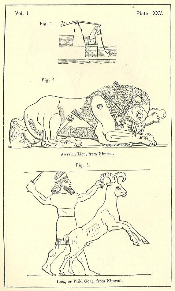
Far different would be the aspect of the region were a due use made of that abundant water supply—actually most lavish in the summer time, owing to the melting of the snows which nature has provided in the two great Mesopotamian rivers and their tributaries. So rapid is the fall of the two main streams in their upper course, that by channels derived from them, with the help perhaps of dams thrown across them at certain intervals, the water might be led to almost any part of the intervening country, and a supply kept up during the whole year. Or, even without works of this magnitude, by hydraulic machines of a very simple construction, the life-giving fluid might be raised from the great streams and their affluents in sufficient quantity to maintain a broad belt on either side of the river-courses in perpetual verdure. Anciently, we know that recourse was had to both of these systems. In the tract between the Tigris and the Upper Zab, which is the only part of Assyria that has been minutely examined, are distinct remains of at least one Assyrian canal, wherein much ingenuity and hydraulic skill is exhibited, the work being carried through the more elevated ground by tunnelling, and the canal led for eight miles contrary to the natural course of every stream in the district. Sluices and dams, cut sometimes in the solid rock, regulated the supply of the fluid at different seasons, and enabled the natives to make the most economical application of the great fertilizer. The use of the hand-swipe was also certainly known, since it is mentioned by Herodotus, and even represented upon the sculptures. [PLATE XXV., Fig. 1.] Very probably other more elaborate machines were likewise employed, unless the general prevalency of canals superseded their necessity. It is certain that over wide districts, now dependent for productive power wholly on the spring rains, and consequently quite incapable of sustaining a settled population, there must have been maintained in Assyrian times some effective water-system, whereby regions that at present with difficulty furnish a few months' subsistence to the wandering Arab tribes, were enabled to supply to scores of populous cities sufficient food for their consumption.
We have not much account of the products of Assyria Proper in early times. Its dates were of small repute, being greatly inferior to those of Babylon. It grew a few olives in places, and some spicy shrubs, which cannot be identified with any certainty. Its cereal crops were good, and may perhaps be regarded as included in the commendations bestowed by Herodotus and Strabo on the grain of the Mesopotamian region. The country was particularly deficient in trees, large tracts growing nothing but wormwood and similar low shrubs, while others were absolutely without either tree or bush. The only products of Assyria which acquired such note as to be called by its name were its silk and its citron trees. The silk, according to Pliny, was the produce of a large kind of silkworm not found elsewhere. The citron trees obtained a very great celebrity. Not only were they admired for their perpetual fruitage, and their delicious odor; but it was believed that the fruit which they bore was an unfailing remedy against poisons. Numerous attempts were made to naturalize the tree in other countries; but up to the time when Pliny wrote, every such attempt had failed, and the citron was still confined to Assyria, Persia and Media.
It is not to be imagined that the vegetable products of Assyria were confined within the narrow compass which the ancient notices might seem to indicate. Those notices are casual, and it is evident that they are incomplete: nor will a just notion be obtained of the real character of the region, unless we take into account such of the present products as may be reasonably supposed to be indigenous. Now setting aside a few plants of special importance to man, the cultivation of which may have been introduced, such as tobacco, rice, Indian corn, and cotton, we may fairly say that Assyria has no exotics, and that the trees, shrubs, and vegetables now found within her limits are the same in all probability as grew there anciently. In order to complete our survey, we may therefore proceed to inquire what are the chief vegetable products of the region at the present time.
In the south the date-palm grows well as far as Anah on the Euphrates and Tekrit on the Tigris. Above that latitude it languishes, and ceases to give fruit altogether about the junction of the Khabour with the one stream and the Lesser Zab with the other. The unproductive tree, however, which the Assyrians used for building purposes, will grow and attain a considerable size to the very edge of the mountains. Of other timber trees the principal are the sycamore and the Oriental plane, which are common in the north the oak, which abounds about Mardin (where it yields gall-nuts and the rare product manna), and which is also found in the Sinjar and Abd-el-Aziz ranges; the silver poplar, which often fringes the banks of the streams; the sumac, which is found on the Upper Euphrates; and the walnut, which grows in the Jebel Tur, and is not uncommon between the foot of Zagros and the outlying ranges of hills. Of fruit-trees the most important are the orange, lemon, pomegranate, apricot, olive, vine, fig, mulberry, and pistachio-nut. The pistachio-nut grows wild in the northern mountains, especially between Orfah and Diarbekr. The fig is cultivated with much care in the Sinjar. The vine is also grown in that region, but bears better on the skirts of the hills above Orfah and Mardin. Pomegranates flourish in various parts of the country. Oranges and lemons belong to its more southern parts, where it verges on Babylonia. The olive clothes the flanks of Zagros in places. Besides these rarer fruits, Assyria has chestnuts, pears, apples, plums, cherries, wild and cultivated, qinces, apricots, melons and filberts.
The commonest shrubs are a kind of wormwood—the apsinthium of Xenophon—which grows over much of the plain extending south of the Khabour—and the tamarisk. Green myrtles, and oleanders with their rosy blossoms, clothe the banks of some of the smaller streams between the Tigris and Mount Zagros; and a shrub of frequent occurrence is the liquorice plant. Of edible vegetables there is great abundance. Truffles and capers grow wild; while peas, beans, onions, spinach, cucumbers, and lentils are cultivated successfully. The carob (Ceratonia Siliqua) must also be mentioned as among the rarer products of this region.
It was noticed above that manna is gathered in Assyria from the dwarf oak. It is abundant in Zagros, and is found also in the woods about Mardin, and again between Orfah and Diarbekr. According to Mr. Rich, it is not confined to the dwarf oak, or even to trees and shrubs, but is deposited also on sand, rocks, and stone. It is most plentiful in wet seasons, and especially after fogs; in dry seasons it fails almost totally. The natives collect it in spring and autumn. The best and purest is that taken from the ground; but by far the greater quantity is obtained from the trees, by placing cloths under them and shaking the branches. The natives use it as food both in its natural state and manufactured into a kind of paste. It soon corrupts; and in order to fit it for exportation, or even for the storeroom of the native housewife, it has to undergo the process of boiling. When thus prepared, it is a gentle purgative; but, in its natural state and when fresh, it may be eaten in large quantities without any unpleasant consequences.
Assyria is far better supplied with minerals than Babylonia. Stone of a good quality, either limestone, sandstone, or conglomerate, is always at hand; while a tolerable clay is also to be found in most plices. If a more durable material is required, basaltic rock may be obtained from the Mons Masius—a substance almost as hard as granite. On the left bank of the Tigris a soft gray alabaster abounds which is easily cut into slabs, and forms an excellent material for the sculptor. The neighboring mountains of Kurdistan contain marbles of many different qualities; and these could be procured without much difficulty by means of the rivers. From the same quarter it was easy to obtain the most useful metals. Iron, copper, and lead are found in great abundance in the Tiyari Mountains within a short distance of Nineveh, where they crop out upon the surface, so that they cannot fail to be noticed. Lead and copper are also obtainable from the neighborhood of Diarbekr. The Kurdish Mountains may have supplied other metals. They still produce silver and antimony; and it is possible that they may anciently have furnished gold and tin. As their mineral riches have never been explored by scientific persons, it is very probable that they may contain many other metals besides those which they are at present known to yield.
Among the mineral products of Assyria, bitumen, naphtha, petroleum, sulphur, alum, and salt have also to be reckoned. The bitumen pits of Kerkuk, in the country between the Lesser Zab and the Adhem, are scarcely less celebrated than those of Hit; and there are some abundant springs of the same character close to Nimrud, in the bed of the Shor Derrell torrent. The Assyrian palaces furnish sufficient evidence that the springs were productive in old times; for the employment of bitumen as a cement, though not so frequent as in Babylonia, is yet occasionally found in them. With the bitumen are always procured both naphtha and petroleum; while at Kerkuk there is an abundance of sulphur also. Salt is obtained from springs in the Kerkuk country; and is also formed in certain small lakes lying between the Sinjar and Babylonia. Alum is plentiful in the hills about Kifri.
The most remarkable wild animals of Assyria are the following: the lion, the leopard, the lynx, the wild-cat, the hyaena, the wild ass, the bear, the deer, the gazelle, the ibex, the wild sheep, the wild boar, the jackal, the wolf, the fox, the beaver, the jerboa, the porcupine, the badger, and the hare. The Assyrian lion is of the maneless kind, and in general habits resembles the lion of Babylonia. The animal is comparatively rare in the eastern districts, being seldom found on the banks of the Tigris above Baghdad, and never above Kileh-Sherghat. On the Euphrates it has been seen as high as Bir; and it is frequent on the banks of the Khabour, and in the Sinjar. It has occasionally that remarkable peculiarity—so commonly represented on the sculptures—a short horny claw at the extremity of the tail in the middle of the ordinary tuft of hair. The ibex or wild goat—also a favorite subject with the Assyrian sculptors—is frequent in Kurdistan, and moreover abounds on the highest ridges of the Abd-el-Aziz and the Sinjar, where it is approached with difficulty by the hunter. The gazelle, wild boar, wolf, jackal, fox, badger, porcupine, and hare are common in the plains, and confined to no particular locality. The jerboa is abundant near the Khabour. Beau's and deer are found on the skirts of the Kurdish hills. The leopard, hyaena, lynx, and beaver are comparatively rare. The last named animal, very uncommon in Southern Asia, was at one time found in large numbers on the Khabour; but in consequence of the value set upon its musk bag, it has been hunted almost to extermination, and is now very seldom seen. The Khabour beavers are said to be a different species from the American. Their tail is not large and broad, but sharp and pointed; nor do they build houses, or construct dams across the stream, but live in the banks, making themselves large chambers above the ordinary level of the floods, which are entered by holes beneath the water-line.
The rarest of all the animals which are still found in Assyria is the wild ass (Equus hemionous). Till the present generation of travellers, it was believed to have disappeared altogether from the region, and to have "retired into the steppes of Mongolia and the deserts of Persia. But a better acquaintance with the country between the rivers has shown that wild asses, though uncommon, still inhabit the tract where, they were seen by Xenophon." [PLATE XXVI., Fig. 1.] They are delicately made, in color varying from a grayish-white in winter to a bright bay, approaching to pink, in the summer-time; they are said to be remarkably swift. It is impossible to take them when full grown; but the Arabs often capture the foals, and bring them up with milk in their tents. They then become very playful and docile; but it is found difficult to keep them alive; and they have never, apparently, been domesticated. The Arabs usually kill them and eat their flesh.
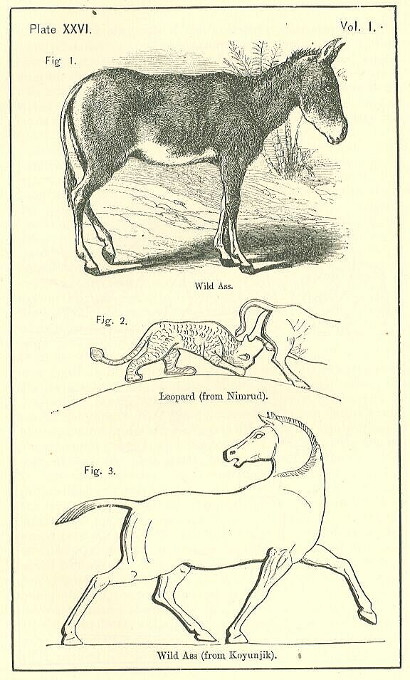
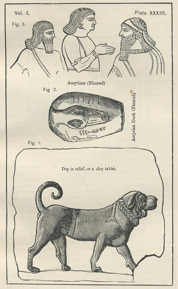
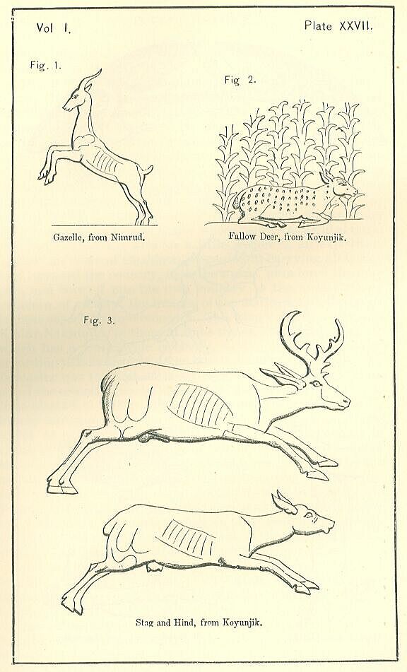
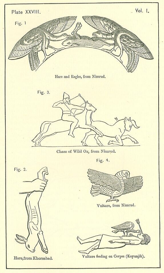
It is probable that all these animals, and some others, inhabited Assyria during the time of the Empire. Lions of two kinds, with and without manes, abound in the sculptures, the former, which do not now exist in Assyria, being the more common. [PLATE XXV., Fig. 2.] They are represented with a skill and a truth which shows the Assyrian sculptor to have been familiar not only with their forms and proportions, but with their natural mode of life, their haunts, and habits. The leopard is far less often depicted, but appears sometimes in the ornamentation of utensils, and is frequently mentioned in the inscriptions. The wild ass is a favorite subject with the sculptors of the late Empire, and is represented with great spirit, though not with complete accuracy. [PLATE XXVI., Fig. 1.] The ears are too short, the head is too fine, the legs are not fine enough, and the form altogether approaches too nearly to the type of the horse. The deer, the gazelle, and the ibex all occur frequently; and though the forms are to some extent conventional, they are not wanting in spirit. [PLATE XXVII.] Deer are apparently of two kinds. That which is most commonly found appears to represent the gray deer, which is the only species existing at present within the confines of Assyria. The other sort is more delicate in shape, and spotted, seeming to represent the fallow deer, which is not now known in Syria or the adjacent countries. It sometimes appears wild, lying among the reeds; sometimes tame, in the arms of a priest or of a winged figure. There is no representation in the sculptures of the wild boar; but a wild sow and pigs are given in one bas-relief, sufficiently indicating the Assyrian acquaintance with this animal. Hares are often depicted, and with much truth; generally they are carried in the hands of men, but sometimes they are being devoured by vultures or eagles. [PLATE XXVIII Figs. 1, 2.] No representations have been found of bears, wild cats, hyaenas, wolves, jackals, wild sheep, foxes, beavers, jerbdas, porcupines, or badgers.
There is reason to believe that two other animals, which have now altogether disappeared from the country, inhabited at least some parts of Assyria during its flourishing period. One of these is the wild bull-often represented on the bas-reliefs as a beast of chase, and perhaps mentioned as such in the inscriptions. This animal, which is sometimes depicted as en-gaged in a contest with the lion, must have been of vast strength and boldness. It is often hunted by the king, and appears to have been considered nearly as noble an object of pursuit as the lion. We may presume, from the practice in the adjoining country, Palestine, 96 that the flesh was eaten as food.
The other animal, once indigenous, but which has now disappeared, was called by the Assyrians the mithin, and is thought to have been the tiger. Tigers are not now found nearer to Assyria than the country south of the Caspian, Ghilan, and Mazanderan; but as there is no conceivable reason why they should not inhabit Mesopotamia, and as the mithin is constantly joined with the lion, as if it were a beast of the same kind, and of nearly equal strength and courage, we may fairly conjecture that the tiger is the animal intended. If this seem too bold a theory, we must regard the mithin as the larger leopard, an animal of considerable strength and ferocity, which, as well as the hunting leopard, is still found in the country. [PLATE XXVI., Fig. 2.]
The birds at present frequenting Assyria are chiefly the following: the bustard (which is of two kinds—the great and the middle-sized), the egret, the crane, the stork, the pelican, the flamingo, the red partridge, the black partridge or francolin, the parrot, the Seleucian thrush (Turdus Seleucus), the vulture, the falcon or hunting hawk, the owl, the wild swan, the bramin goose, the ordinary wild goose, the wild duck, the teal, the tern, the sand-grouse, the turtle dove, the nightingale, the jay, the plover, and the snipe. There is also a large kite or eagle, called "agab," or "the butcher," by the Arabs, which is greatly dreaded by fowlers, as it will attack and kill the falcon no less than other birds.
We have little information as to which of these birds frequented the country in ancient times. The Assyrian artists are not happy in their delineation of the feathered tribe; and though several forms of birds are represented upon the sculptures of Sargon and elsewhere, there are but three which any writer has ventured to identify—the vulture, the ostrich, and the partridge. The vulture is commonly represented flying in the air, in attendance upon the march and the battle—sometimes devouring, as he flies, the entrails of one of Assyria's enemies. Occasionally he appears upon the battle-field, perched upon the bodies of the slain, and pecking at their eyes or their vitals. [PLATE XXVIII., Fig. 4.] The ostrich, which we know from Xenophon to have been a former inhabitant of the country on the left bank of the Euphrates, but which has now retreated into the wilds of Arabia, occurs frequently upon cylinders, dresses, and utensils; sometimes stalking along apparently unconcerned; sometimes hastening at full speed, as if pursued by the hunter, and, agreeably to the description of Xenophon, using its wing for a sail. [PLATE XXIX., Figs. 1, 2.] The partridge is still more common than either of these. He is evidently sought as food. We find him carried in the hand of sportsmen returning from the chase, or see him flying above their heads as they beat the coverts, or finally observe him pierced by a successful shot, and in the act of falling a prey to his pursuers. [PLATE XXIX., Fig. 3.]
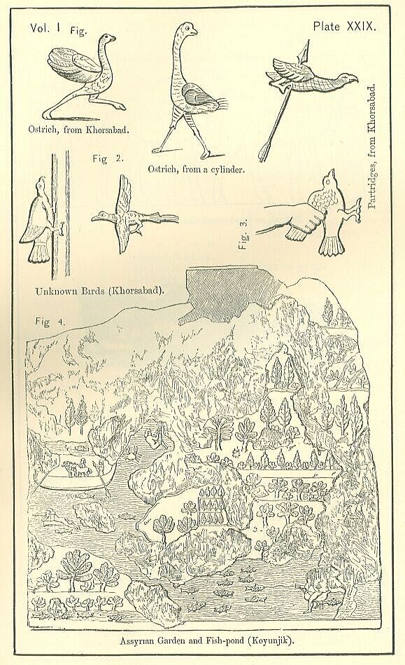
The other birds represented upon the sculptures, though occasionally possessing some marked peculiarities of form or habit, have not yet been identified with any known species. [PLATE XXIX., Fig. 2.] They are commonly represented as haunting the fir-woods, and often as perched upon the trees. One appears, in a sculpture of Sargon's. in the act of climbing the stein of a tree, like the nut-hatch or the woodpecker. Another has a tail like a pheasant, but in other respects cannot be said to resemble that bird. The artist does not appear to aim at truth in these delineations, and it probably would be a waste of ingenuity to conjecture which species of bird he intended.
We have no direct evidence that bustards inhabited Mesopotamia in Assyrian times; but as they have certainly been abundant in that region front the time of Xenophon to our own, there can be little doubt that they existed in some parts of Assyria during the Empire. Considering their size, their peculiar appearance, and the delicacy of their flesh, it is remarkable that the Assyrian remains furnish no trace of them. Perhaps, as they are extremely shy, they may have been comparatively rare in the country when the population was numerous, and when the greater portion of the tract between the rivers was brought under cultivation.
The fish most plentiful in Assyria are the same as in Babylonia, namely, barbel and carp. They abound not only in the Tigris and Euphrates, but also in the lake of Khutaniyeh, and often grow to a great size. Trout are found in the streams which run down from Zagros; and there may be many other sorts which have not yet been observed. The sculptures represent all the waters, whether river, pond, or marsh, as full of fish; but the forms are for the most part too conventional to admit of identification. [PLATE XXIX., Fig. 3.]
The domestic animals now found in Assyria are camels, horses, asses, mules, sheep, goats, oxen, cows, and dogs. The camels are of three colors—white, yellow, and dark brown or black. They are probably all of the same species, though commonly distinguished into camels proper, and delouls or dromedaries, the latter differing from the others as the English race-horse from the cart-horse. The Bactrian or two-humped camel, though known to the ancient Assyrians, is not now found in the country. [PLATE XXX., Fig. 1.] The horses are numerous, and of the best Arab blood. Small in stature, but of exquisite symmetry and wonderful powers of endurance, they are highly prized throughout the East, and constitute the chief wealth of the wandering tribes who occupy the greater portion of Mesopotamia. The sheep and goats are also of good breeds, and produce wool of an excellent quality. [PLATE XXX., Fig. 2.] The cows and oxen cannot be commended. The dogs kept are chiefly greyhounds, which are used to course the hare and the gazelle.
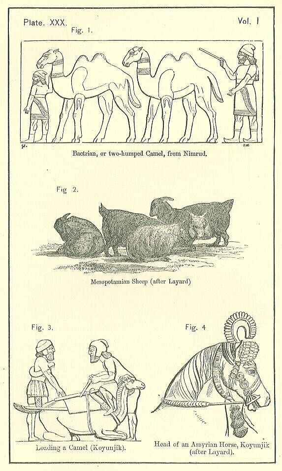
It is probable that in ancient times the animals domesticated by the Assyrians were not very different from these. The camel appears upon the monuments both as a beast of burden and also as ridden in war, but only by the enemies of the Assyrians. [PLATE XXX., Fig. 3.] The horse is used both for draught and for riding, but seems never degraded to ignoble purposes. His breed is good, though he is not so finely or delicately made as the modern Arab. The head is small and well shaped, the nostrils large and high, the neck arched, but somewhat thick, the body compact, the loins strong, the legs moderately slender and sinewy. [PLATE XXX., Fig. 4.] [PLATE XXXI., Fig. 1.] The ass is not found; but the mule appears, sometimes ridden by women, sometimes used as a beast of burden, sometimes employed in drawing a cart. [PLATE XXXI., Fig. 2] [PLATE XXXII., Figs. 1, 2.] Cows, oxen, sheep, and goats are frequent; but they are foreign rather tham Assyrian, since they occur only among the spoil taken from conquered countries. The dog is frequent on the later sculptures; and has been found modelled in clay, and also represented in relief on a clay tablet. [PLATE XXXII., Fig. 3.] [PLATE XXXIII., Fig. 1.] Their character is that of a large mastiff or hound, and there is abundant evidence that they were employed in hunting.
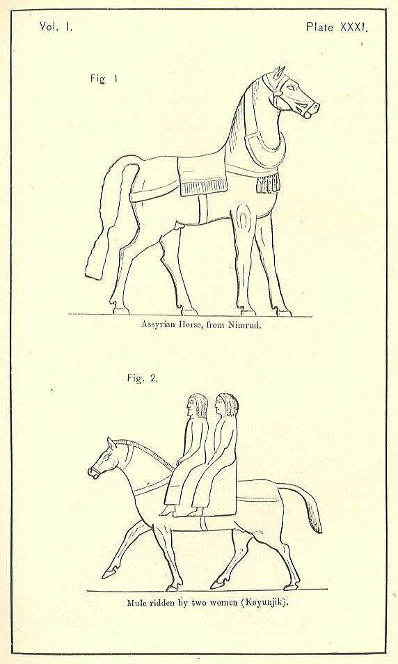
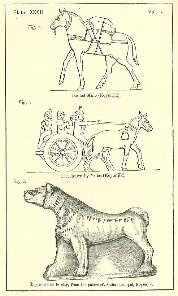
If the Assyrians domesticated any bird, it would seem to have been the duck. Models of the duck are common, and seem generally to have been used for weights. [PLATE XXXIII., Fig. 2.] The bird is ordinarily represented with its head turned upon its back, the attitude of the domestic duck when asleep. The Assyrians seem to have had artificial ponds or stews, which are always represented as full of fish, but the forms are conventional, as has been already observed. Considering the size to which the carp and barbel actually grow at the present day, the ancient representations are smaller than might have been expected.